- Forest Hills (MBTA station)
Infobox Station
name=Forest Hills Station
type=MBTARapid transit and commuter rail station
image_size=250
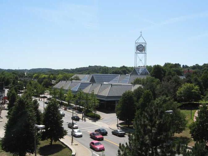
image_caption="Forest Hills Station, looking south from the Casey Overpass"
address=Washington Street and Hyde Park Avenue, Jamaica Plain
coordinates = coord| 42.2988|-71.1149 |display=inline,title
line=
other=
platform=
parking=206 spaces, 5 accessbile, $4.00 fee
bicycle=31 spaces
passengers=
pass_year=
pass_percent=
opened=1909 as original elevated station (closed 1987 when Elevated Line was demolished)
rebuilt=May 4, 1987 as part of Orange Line realignment
ADA=Yes
code=
owned=Massachusetts Bay Transportation Authority
zone=
services=Forest Hills Station is a station on the MBTA Orange Line, located in Forest Hills in the southern part of the Jamaica Plain neighborhood of
Boston, Massachusetts at the intersections of Washington Street, Hyde Park Avenue, South Street,The Arborway and Morton Street.Forest Hills is the southern terminus of the MBTA Orange Line. It serves nearby residential neighborhoods and is also a major bus transfer station with connections to 14 routes. Commuter trains on the MBTA's
Needham Line line also serve the station.The adjacent Arborway Station was the terminus of the
Green Line "E" Branch until1985 , when service on the "E" branch was cut back to Heath Street. Restoration of Green Line trolley service to Arborway is part of remediation for the Big Dig, but the MBTA has been reluctant to restore the service. [http://www.arborway.net/lrv/]Facilities
Several small retailers are located in the station, including a donut/coffee shop, newspaper stand and florist. During warmer months a farmer's stand is set up. In addition the station features an MBTA Police substation.
206
park and ride parking spaces are available on the station grounds. Overnight parking is not allowed.Attractions
The station is surrounded by large parks, to the north of the station is
Harvard University 'sArnold Arboretum , one end of Boston'sEmerald Necklace of parks. To the south is theForest Hills Cemetery and Franklin Park. The station also marks the beginning of the linear Southwest Corridor Park.Architecture
The station was designed by
Cambridge Seven Associates constructed of brick, steel and glass, the architecture is meant to reflect thegreenhouse s of the surrounding parks. The station'sclock tower has become a local landmark.MBTA Bus Connections*16 Forest Hills Station -
UMASS Boston or Andrew Station
*21 Ashmont Station - Forest Hills Station via Morton Street
*30 Mattapan Station - Forest Hills Station via Cummings Hwy
*31 Mattapan Station - Forest Hills Station via Morton Street
*32 Wolcott Square or Cleary Square - Forest Hills Station via Hyde Park Ave
*34 Walpole Center or Dedham Line - Forest Hills Station via Washington Street
*34E Walpole Center or Dedham Line - Forest Hills Station via Washington Street & Dedham Mall
*35 Dedham Mall - Forest Hills Station via Centre Street
*36 Charles River Loop or V.A. Hospital - Forest Hills Station via Centre Street
*37 Baker & Vermont Streets - Forest Hills Station via Centre Street
*38 Wren Street - Forest Hills Station via Centre & South Streets
*39 Forest Hills Station - Back Bay Station via Huntington Ave (Replacement for the "temporarily" suspended portion of the "E" line past Heath Street)
*40 Georgetowne - Forest Hills Station via Washington Street
*42 Forest Hills Station - Dudley Station or Ruggles Station via Washington Street
*50 Forest Hills Station - Cleary Square via Roslindale Square
*51 Cleveland Circle - Forest Hills Station via Hancock VillageAccessibility
The station is fully wheelchair accessible.
External links
* [http://www.mbta.com/schedules_and_maps/subway/lines/stations/?stopId=11788&lat=42.300023&lng=-71.113377 The MBTA's official page for this station.]
* [http://world.nycsubway.org/us/boston/orange/mbta-orange-forest.html Photos of this station from world.nycsubway.org]
* [http://www.c7a.com/portfolio/Transportation/mbta_forest_hills.asp Cambridge Seven Associates project page]
Wikimedia Foundation. 2010.