- Shire of Heywood
Infobox Australian Place | type = lga
name = Shire of Heywood
state = vic
region =
area = 3764
est = 1856
seat = Heywood
pop = 7500 (1992) [cite book|title=Victorian Year Book|author=Australian Bureau of Statistics, Victoria Office|year=1994|page=49-52|id=ISSN 0067-1223]
logosize =
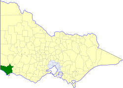
caption = Location in Victoria
county = Normanby, Follett
near-nw = "Penola (SA)"
near-n = Glenelg
near-ne = Dundas
near-w = "Mount Gambier (SA)" "Port MacDonnell (SA)"
near-e = Minhamite
near-sw = "Southern Ocean "
near-s = Portland
near-se = Belfast
_noautocat = yesThe Shire of Heywood was a Local Government Area located about convert|360|km|mi|0 west-southwest of
Melbourne , the state capital of Victoria,Australia . The shire covered an area of convert|3764|km2|sqmi|1, and existed from 1856 until 1994. It was for most of its life known as the Shire of Portland.History
Heywood was first incorporated as a district on 25 January 1856, and became a shire on 8 December 1863. On 23 April 1958 and 31 May 1968, it lost parts of its area to the
City of Portland , and on 1 October 1988 it was renamed the Shire of Heywood.cite book|title=Victorian Municipal Directory|year=1992|publisher=Arnall & Jackson|location=Brunswick|pages=704-705 Accessed atState Library of Victoria , La Trobe Reading Room.]On 23 September 1994, the Shire was abolished, and merged with City of Portland and most of the Shire of Glenelg into the
Shire of Glenelg . [cite book|url=http://www.ausstats.abs.gov.au/ausstats/free.nsf/0/76E601D6DB55E88ACA25722500049195/$File/12570_1994-95.pdf|title=Victorian local government amalgamations 1994-1995: Changes to the Australian Standard Geographical Classification|author=Australian Bureau of Statistics |date=1 August 1995|publisher=Commonwealth of Australia|page=6,11|isbn=0-642-23117-6|accessdate=2008-01-05]Wards
Heywood was divided into four ridings, each of which elected three councillors:
* East Riding
* South Riding
* West Riding
* Central RidingTowns and Localities
Population
* Estimate in the 1958 Victorian Year Book.
References
Wikimedia Foundation. 2010.