- Military Park (Indianapolis)
-
For other parks named Military Park, see Military Park.Military Park

Location: Indianapolis, Indiana Built: 1852 Architectural style: No Style Listed Governing body: State NRHP Reference#: 69000002
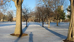
[1]Added to NRHP: October 28, 1969 Military Park is the oldest park in Indianapolis, Indiana, covering 14 acres (6 ha). In accordance with the Indiana Constitution, the land that forms Military Park cannot be sold; only Monument Circle and half of the Indiana State Capitol share this distinction. [2][3]
History
Ever since the founding of Indianapolis in 1820, the grounds of Military Park, originally called Military Ground, have seen various uses. The first documented celebration of Independence Day in Indianapolis occurred at Military Ground on July 4, 1822. The United States Congress officially gave the land to the state of Indiana in 1827, for use in training the local militias. Before 1860, its greatest use for militia training was for the Black Hawk War in 1836.[4]
The 1851 Indiana Constitution forbids the selling of Military Park. The first Indiana State Fair was held at the park in October 1852. Save for the years during which the fair traveled, the site was used for the state fair until it moved, in 1860, to the site where, during the Civil War, Camp Morton would be built. Stalls and exhibition halls were built on the grounds for such a purpose, surrounded by a large wooden fence. The State Fair made one last appearance on Military Park in 1863.[4]
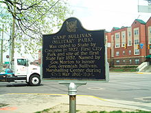
During the Civil War, Union soldiers were encamped at the Park. Governor Oliver P. Morton renamed the park Camp Sullivan, after the 13th Indiana Infantry's Colonel Jeremiah C. Sullivan. It was the first designated camp for the Federal army in Marion County, Indiana. However, this use severely damaged the grounds, due to all of the different troops entering and leaving Camp Sullivan, as it was a marshaling center. Following the war, efforts by local resident George Merritt started to improve the grounds, with the addition of a fountain and a small pool with a considerable-size rock foundation. Relics from the war and playground equipment were also added, as was a pavilion that still stands.[5][6]
William Jennings Bryan was notified that he would be the Democrat nominee for the Presidency of the United States on August 7, 1900. The two hour rally was preceded by a march by the candidates from Indianapolis's Union Station.[7]
In 1916 the park was renamed Camp Sullivan Park. Between World War I and World War II, the park began to deteriorate. By now again known as Military Park, its diminished status continued until 1980, when the Lilly Endowment and Krannert Charitable Trust granted funds for its improvement.[8] In 1979 it become part of White River State Park.[9]
Today
Military Park hosts several events, such as rallies, festivals, and outdoor concerts.
In 2007 the park's shelter house was renovated for over $700,000.[10]
References
- ^ "National Register Information System". National Register of Historic Places. National Park Service. 2007-01-23. http://nrhp.focus.nps.gov/natreg/docs/All_Data.html.
- ^ Bodenhamer, David. The Encyclopedia of Indianapolis (Indiana University Press, 1994) pg.1008
- ^ White River State Park
- ^ a b Bodenhamer 1008
- ^ Camp Sullivan (Military Park) Marker
- ^ Bodenhamer 443, 1008, 1009
- ^ All ready at Indianapolis; The Town Completes Arrangements For the Bryan Notification Ceremonies, New York Times, August 6, 1900
- ^ Bodenhamer 1008, 1009
- ^ Bodenhamer 1009
- ^ Shelter House at Military Park Gets a Makeover - Newsroom - Inside INdiana Business with Gerry Dick
People William A. Bowles · Jesse D. Bright · Ambrose Burnside · Harrison H. Dodd · Andrew Humphreys · Lambdin P. Milligan · Oliver Morton · Francis A. Shoup · Lew Wallace · Indiana regiments
Places Camp Joe Holt · Camp Morton · Jefferson General Hospital · Jeffersonville Quartermaster Depot · Military Park · New Albany National CemeteryBattles/Raids See also: Timeline of Indiana in the American Civil War and Indianapolis in the American Civil WarNational Register of Historic Places in Indianapolis, Indiana Administration Building, Indiana Central University • The Alameda • The Alexandra • Alfred M. Glossbrenner Mansion • Allison Mansion • The Ambassador • Anderson-Thompson House • Arthur Jordan Memorial Hall • Aston Inn • Athenaeum (Das Deutsche Haus) • August Sommer House • L.S. Ayres Annex Warehouse • The Baker • Balmoral Court • Bals-Wocher House • Bates-Hendricks House • Benjamin Franklin Public School Number 36 • Benjamin Harrison House • Benton House • Bethel A.M.E. Church • Big Run Baptist Church and Cemetery • Joseph J. Bingham Indianapolis Public School No. 84 • The Blacherne • Brendonwood Historic District • Broad Ripple Park Carousel • The Buckingham • The Burton • Bush Stadium • Butler Fieldhouse • Byram-Middleton House • Calvin I. Fletcher House • Camp Edwin F. Glenn • Carlos and Anne Recker House • The Cathcart • Central Court Historic District • Central Library (Indianapolis-Marion County Public Library) • The Chadwick • Charles Kuhn House • Chatham-Arch Historic District • Christ Church Cathedral • Christamore House • Christian Park School No. 82 • Circle Theater • City Market • Cole Motor Car Company • The Colonial • Columbia Club • Cottage Home Historic District • Cotton-Ropkey House • Coulter Flats • Crispus Attucks High School • Crown Hill Cemetery • Crown Hill National Cemetery • The Dartmouth • Delaware Court • Delaware Flats • The Devonshire • The Emelie • Ralph Waldo Emerson Indianapolis Public School No. 58 • Esplanade Apartments • Fidelity Trust Building • Flanner House Homes • Fletcher Place Historic District • Forest Hills Historic District • Fort Benjamin Harrison Historic District • Fort Benjamin Harrison Historic District (Boundary Increase) • Foster Hall • General German Protestant Orphans Home • George Philip Meier House • George Stumpf House • George Washington Tomlinson House • The Glencoe • Golden Hill Historic District • The Grover • Hammond Block (Budnick's Trading Mart) • Hanna-Ochler-Elder House • The Harriett • Haughville Historic District • Hawthorne Branch Library No. 2 • Heier's Hotel • Henry F. Campbell Mansion • Henry P. Coburn Public School No. 66 • Herron-Morton Place Historic District • Hillcrest Country club • Hiram A. Haverstick Farmstead • Hollingsworth House • Holy Rosary-Danish Church Historic District • Horace Mann Public School No. 13 • Hotel Washington • Independent Turnverein • Indiana Avenue Historic District • Indiana Oxygen Company • Indiana School for the Deaf • Indiana Statehouse • Indiana State Federation of Colored Women's Clubs • Indiana State Library and Historical Building • Indiana Theatre • Indiana World War Memorial Plaza • Indianapolis Fire Headquarters and Municipal Garage • Indianapolis Masonic Temple • Indianapolis Motor Speedway • Indianapolis News Building • Indianapolis Park and Boulevard System • Indianapolis Union Railroad Station • Indianapolis Union Station-Wholesale District • Irvington Historic District • James Whitcomb Riley House • Jamieson-Bennett House • John Fitch Hill House • John Greenleaf Whittier School, No. 33 • Johnson-Denny House • Joseph J. Cole, Jr., House and 1925 Cole Brouette No. 70611 • Julian-Clark House • Laurel and Prospect District • Linwood Colonial Apartments • Lockefield Garden Apartments • Lockerbie Square Historic District • Lockerbie Square Historic District Amendment (Boundary Increase) • The Lodge • Lombard Building • Louis Levey Mansion • Madame C. J. Walker Building • Majestic Building • Manchester Apartments • Marcy Village Apartments • Marion County Bridge 0501F • Marott Hotel • Marott's Shoes Building • Martens • Massachusetts • Massachusetts Avenue Commercial District • Mayleeno • McCormick Cabin Site • McKay • Merchants National Bank and Annex • Meridian Park Historic District • Michigan Road Toll House • Military Park • Morris-Butler House • Morrison Block (M. O'Connor Grocery Wholesalers) • Mt. Pisgah Lutheran Church • Myrtle Fern • New Augusta Historic District • Nicholson-Rand House • North Meridian Street Historic District • Northside Historic District • North Irvington Gardens Historic District • Nurses' Sunken Garden and Convalescent Park • Oldfields • Old Indianapolis City Hall • Old Northside Historic District • Old Pathology Building • Old Southport High School • Oliver Johnson's Woods Historic District • Oxford • Pearson Terrace • Pennsylvania • Pierson-Griffiths House • Plaza • The Propylaeum (John W. Schmidt House) • Prosser House • Ransom Place Historic District • Reserve Loan Life Insurance Company • Rink • Rink's Women's Apparel Store • Rivoli Theater • Roberts Park Methodist Episcopal Church • Roy and Iris Corbin Lustron House • Saint James Court • St. John's Church and Rectory • St. Joseph Neighborhood Historic District • St. Mary's Catholic Church • St. Philip Neri Parish Historic District • Savoy • Schnull-Rauch House • Scottish Rite Cathedral • Selig's Dry Goods Company Building • The Seville • Sheffield Inn • Shelton • Shortridge High School • Sid-Mar • Spink • Spink Arms Hotel • State Soldiers and Sailors Monument • State and Prospect District • Stewart Manor (Charles B. Sommers House) • Sylvania • Taylor Carpet Company Building • Test Building • Thomas Askren House • Thomas Moore House • Town of Crows Nest Historic District • U.S. Arsenal (Arsenal Technical High School) • U.S. Courthouse and Post Office • University Park • Vera and the Olga • Vienna • Virginia Avenue District • Washington Park Historic District • Washington Street-Monument Circle Historic District • H. P. Wasson and Company Building • West Washington Street Pumping Station • Wheeler-Schebler Carburetor Company • Wheeler-Stokely Mansion • Wil-Fra-Mar • William Buschmann Block • William H. H. Graham House • William N. Thompson House • Wilson • Woodruff Place • Woodstock Country Club • Wyndham • YWCA Blue Triangle Residence Hall
National Register of Historic Places in Indianapolis State Parks 
Regional parks Eagle Creek • Garfield • Riverside • Sahm • Southeastway • Southwestway
Community parks Bethel • Broad Ripple • Brookside • Christian • Douglass • Ellenberger • Glenns Valley Nature • Holliday • JTV Hill • Krannert • Municipal Gardens • Northwestway • Perry • Post Road • Raymond (Indy Island) • Rhodius • Thatcher • Washington • Watkins • Windsor Village
Natural resource areas Skiles Test Nature Park
Downtown spaces Military Park • Obelisk Square • University Park
Waterways Eagle Creek • Fall Creek • Central Canal • Pleasant Run • Pogue's Run • White River
Trails Central Canal Towpath • Eagle Creek • Fall Creek • Little Buck Creek • Monon • Pennsy Rail • Pleasant Run • Pogue's Run • Town Run • White River/Wapahani
Zoological and botanical See also List of attractions and events in Indianapolis Coordinates: 39°46.226′N 86°10.114′W / 39.770433°N 86.168567°W
Categories:- Historic districts in Indiana
- National Register of Historic Places in Indianapolis, Indiana
- Historic districts in Indianapolis, Indiana
- Parks in Indianapolis, Indiana
Wikimedia Foundation. 2010.

