- Shire of Myrtleford
Infobox Australian Place | type = lga
name = Shire of Myrtleford
state = vic
region =
area = 800
est = 1960
seat = Myrtleford
pop = 4370 (1992) [cite book|title=Victorian Year Book|author=Australian Bureau of Statistics, Victoria Office|year=1994|page=49-52|id=ISSN 0067-1223]
logosize =
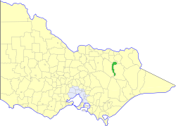
caption = Location in Victoria
county = Bogong, Delatite
near-nw = Beechworth
near-n = Beechworth
near-ne = Yackandandah
near-w = Oxley
near-e = Bright
near-sw = Mansfield
near-s = Maffra
near-se = Bright
_noautocat = yesThe Shire of Myrtleford was a Local Government Area located about convert|280|km|mi|0 northeast of
Melbourne , the state capital of Victoria,Australia . The shire covered an area of convert|800|km2|sqmi|1, and existed from 1960 until 1994.History
Myrtleford was created out of part of the
Shire of Bright on 31 May 1960.cite book|title=Victorian Municipal Directory|year=1992|publisher=Arnall & Jackson|location=Brunswick|pages=776-777 Accessed atState Library of Victoria , La Trobe Reading Room.]On 18 November 1994, the Shire was abolished, and merged with the
Shire of Bright and various surrounding districts into theAlpine Shire . [cite book|url=http://www.ausstats.abs.gov.au/ausstats/free.nsf/0/76E601D6DB55E88ACA25722500049195/$File/12570_1994-95.pdf|title=Victorian local government amalgamations 1994-1995: Changes to the Australian Standard Geographical Classification|author=Australian Bureau of Statistics |date=1 August 1995|publisher=Commonwealth of Australia|page=4|isbn=0-642-23117-6|accessdate=2008-01-05]Wards
Myrtleford was not divided into ridings, and its nine councillors represented the entire district.
Towns and Localities
* Myrtleford
* Barwidgee
* Buffalo River
* Merriang
* OvensPopulation
* Estimate in the 1958 Victorian Year Book.
References
Wikimedia Foundation. 2010.