Creeton

Creeton

Coordinates: 52°45′58″N 0°30′13″W / 52.765995°N 0.50348952°W / 52.765995; -0.50348952

Creeton
Church of St Peter, Creeton - geograph.org.uk - 289593.jpg
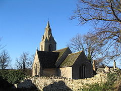
St Peter's church, Creeton
Creeton is located in Lincolnshire
Creeton

 Creeton shown within Lincolnshire
OS grid reference TF 01071 19760
District South Kesteven
Shire county Lincolnshire
Region East Midlands
Country England
Sovereign state United Kingdom
Post town Grantham
Postcode district NG33
Police Lincolnshire
Fire Lincolnshire
Ambulance East Midlands
EU Parliament East Midlands
UK Parliament Grantham and Stamford
List of places: UK • England • Lincolnshire

Creeton is a hamlet in the civil parish of Counthorpe and Creeton in the South Kesteven district of Lincolnshire, England. It lies 5 miles south west from Bourne and 3 miles south from Corby Glen, on the River Glen

Creeton Grade I listed Anglican parish church is dedicated to St Peter.[1] It is of late Decorated style. During restoration in 1851 the piers and arches of a former Norman aisle were discovered. The church holds a chained 1611 bible. In the churchyard are two examples of Saxon grave crosses, and 20 stone coffins considered to mark the internment of Cistercian monks of Vallis Dei abbey in the neighbouring Edenham parish.[2]

There are no amenities in Creeton; the nearest school is in Little Bytham, with shops in Corby Glen, Little Bytham and Castle Bytham, and public house in Swinstead. The hamlet consists of around 20 households.

References

  1. ^ "Church of St Peter", National Heritage List for England, English Heritage. Retrieved 19 July 2011
  2. ^ Cox, J. Charles (1916) Lincolnshire p. 108; Methuen & Co. Ltd

External links

Media related to Creeton at Wikimedia Commons


Wikimedia Foundation. 2010.

Игры ⚽ Нужен реферат?

Look at other dictionaries:

  • Counthorpe — Coordinates: 52°46′00″N 0°30′00″W / 52.766701°N 0.49999997°W / 52.766701; 0.49999997 …   Wikipedia

  • South Kesteven — Infobox UK district name = South Kesteven District status = District region = East Midlands admincounty = Lincolnshire area = Ranked 31st 942.59 km² adminhq = Grantham onscode = 32UG population = Ranked English district rank|ONS=32UG English… …   Wikipedia

  • List of places in Lincolnshire — This is a list of places in the ceremonial county of Lincolnshire, England. See the list of places in England for places in other counties.compactTOC NOTOC A *Aby, Addlethorpe, Aisby, South Kesteven, Aisby, West Lindsey, Aisthorpe, Alford,… …   Wikipedia

  • List of civil parishes in Lincolnshire — This is a list of civil parishes in the ceremonial county of Lincolnshire, England. =Boston= Boston itself is an unparished area.*Algarkirk *Amber Hill *Benington *Bicker *Butterwick *Fishtoft *Fosdyke *Frampton *Freiston *Holland Fen with… …   Wikipedia

  • Castle Bytham — is a picturesque village of around 300 houses in South Kesteven in south Lincolnshire at gbmapping|SK990185. Overlooking the village is an 11th century Saxon castle, which was destroyed by Henry III in 1221, even though he was only fourteen.The… …   Wikipedia

  • For Madmen Only (UK Decay album) — Infobox Album Name = For Madmen Only Type = Album Artist = UK Decay Released = October 1981 Recorded = Genre = Length = Label = Fresh Records Fresh LP5, UK Decay Records Producer = Reviews = Last album = This album = For Madmen Only Next album =… …   Wikipedia

  • Delaine Buses — The Delaine logo. The first ever East Lancs Olympus, seen at the 2007 Longcross bus rally …   Wikipedia

  • Swayfield — is a small village of approximately 138 houses situated just off the A1 in South Kesteven, southern Lincolnshire, England.GeographyThe [http://www.geograph.org.uk/photo/289489 village] is eight miles from Bourne (via the A151), twelve miles from… …   Wikipedia

  • Witham on the Hill — is a well maintained [http://www.geograph.org.uk/photo/203021 village] in the civil parish of the same name. Coordinates 52°44.04 N 0°26.26 W. It lies in the district of South Kesteven in south west Lincolnshire, between Stamford and Bourne.The… …   Wikipedia

  • Swinstead — is a small village of just over 100 households, located 5 miles to the east of Bourne in southern Lincolnshire. Although close to Bourne and Stamford (9 miles), it is actually in the Grantham post code. The village is served by the local pub,… …   Wikipedia

Share the article and excerpts

Direct link
Do a right-click on the link above
and select “Copy Link”