- M-42 (Michigan highway)
-
This article is about the state highway in Michigan; for other uses, see M42 (disambiguation)
M-42
M-42 highlighted in redRoute information Maintained by MDOT Length: 10.339 mi[2] (16.639 km) Existed: ca. July 1, 1919[1] – present Major junctions West end: 


 BUS US 131 in Manton US 131 in Manton
East end:  M-66 near Lake City
Location Counties: Wexford, Missaukee Highway system Michigan State Trunkline Highway System
Interstate • US • State←  M-41
M-41M-43  →
→M-42 is a rural state trunkline highway in the U.S. state of Michigan. It is located in the northwestern Lower Peninsula of the state. Along its route, M-42 begins in Manton and ends north of Lake City, some 10.356 miles (16.666 km) apart. The highway used to run much farther. Former termini included the Traverse City area from 1919 until 1940 and Mesick from 1940 until 2007.
Contents
Route description
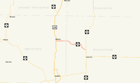
M-42 is a rural, two-lane highway connecting Manton and Lake City.[3] It runs through wooded terrain on gently rolling hills. Between the western terminus at Michigan Avenue and the US 131 freeway in Manton, M-42 is concurrently designated with BUS US 131 along Seventh Street. It runs east along Seventh Street to a folded diamond interchange at Exit 191 on US 131 east of downtown. Continuing east, it is known as North 16½ Road until it crosses the Wexford–Missaukee county line at Seeley Road approximately 2.5 miles (4.0 km) east of the freeway. Here the road name changes to Mike and Tony Road before M-42 curves southeasterly crossing Morrisy Creek on West Walker Road. East of the unincorporated community of Arlene the highway turns ninety degrees to the south off Walker Road before angling southeasterly skirting the edge of some hills near Dyer Lake just west of M-66. The road turns back due east between Al Moses Road and M-66, where it ends north of Lake City.[4] No section of the trunkline is part of the National Highway System.[5]
History
M-42 is an original state trunkline dating back to the 1919 signage of the highway system in Michigan. The original highway routing started at M-13 in Manton and ran due west to Mesick. From there the highway turned north and met M-11 at Chums Corners. M-11/M-42 ran concurrently northward into the City of Traverse City where M-42 ended.[1] By May 1929, M-42 was extended east to connect to Lake City.[6] The highway was further extended before 1936 up the Old Mission Peninsula north of Traverse City.[7] In the latter half of 1940, the M-37 designation replace M-42 north of Mesick through Traverse City to Old Mission.[8][9] The last sections of highway were paved in late 1951 and early 1952.[10][11]
In 2007, the stretch of M-42 between M-37 and US 131 along 16 Road was transferred to the Wexford County Road Commission.[12] This change shortened the highway from 25.255 miles (40.644 km) to 10.356 miles (16.666 km).[2] The section of transferred highway in Wexford County was labeled as "flexible pavements" on the 2006 MDOT Truck Operators Map. This classification meant truck traffic on the roadway was subject to weight and load restrictions during spring. This classification is unlike the other highways in the county and surrounding area which were marked as "all-weather highways" and would not carry such restrictions.[13]
Major intersections
County Location Mile[2][14] Destinations Notes Wexford Manton 0.000
BUS US 1310.842 
US 131 / BUS US 131Exit 191 on US 131; southern terminus of BUS US 131 Missaukee Lake City 10.339 M-66 – Kalkaska, McBain1.000 mi = 1.609 km; 1.000 km = 0.621 mi
Concurrency terminus • Closed/Former • Incomplete access • UnopenedReferences
- ^ a b Michigan State Highway Department (1919). State of Michigan (Map). Cartography by MSHD. http://maps.lib.msu.edu/miroadmaps/mirm5.htm. Retrieved March 2, 2008.
- ^ a b c Michigan Department of Transportation (2009). Control Section/Physical Reference Atlas (Map). http://mdotwas1.mdot.state.mi.us/public/maps/pr/. Retrieved July 26, 2009.
- ^ Michigan Department of Transportation (2008). Official 2008 Department of Transportation Map (Map). 1 in:15 mi/1 cm:9 km. Section H9.
- ^ Google, Inc. Google Maps – S Michigan Ave & E 7th St, Manton, MI 49663 to M-66 & M-42, Lake City, MI 49651 (Map). Cartography by Google, Inc. http://maps.google.com/maps?saddr=S+Michigan+Ave+%26+E+7th+St,+Manton,+MI+49663&geocode=&dirflg=&daddr=M-42+%26+M-66,+Lake+City,+MI&f=d&sll=44.403776,-85.398242&sspn=0.00975,0.014334&ie=UTF8&t=p&z=12. Retrieved September 30, 2008.
- ^ Michigan Department of Transportation (April 23, 2006) (PDF). National Highway System, Michigan (Map). http://www.michigan.gov/documents/MDOT_NHS_Statewide_150626_7.pdf. Retrieved February 4, 2008.
- ^ Michigan State Highway Department (May 1, 1929). Official Highway Map (Map). Cartography by MSHD.
- ^ Michigan State Highway Department (June 1, 1936). Official Michigan Highway Map (Map). Cartography by Rand McNally.
- ^ Michigan State Highway Department (July 15, 1940). Official Michigan Highway Map (Map). Cartography by Rand McNally.
- ^ Michigan State Highway Department (December 1, 1940). Official Michigan Highway Map (Map). Cartography by Rand McNally.
- ^ Michigan State Highway Department (July 1, 1951). Official Michigan Highway Map (Map). Cartography by Rand McNally.
- ^ Michigan State Highway Department (April 1, 1952). Official Michigan Highway Map (Map). Cartography by Rand McNally.
- ^ Wexford County Road Commission (December 31, 2007). "Financial Statements and Supplementary Information" (pdf). Michigan Department of Treasury. http://www.michigan.gov/documents/treasury/830100WexfordRoad20080616_238651_7.pdf. Retrieved September 30, 2008.
- ^ Michigan Department of Transportation (2006). Truck Operators Map (Map).
- ^ "MDOT Physical Reference Finder Application". Michigan Department of Transportation. 2009. http://www.mcgi.state.mi.us/prfinder/. Retrieved April 9, 2010.
External links
Categories:- State highways in Michigan


Wikimedia Foundation. 2010.