- Myerstown, Pennsylvania
-
Myerstown, Pennsylvania — Borough — 
 Myerstown, Pennsylvania
Coordinates: 40°22′19″N 76°18′15″W / 40.37194°N 76.30417°WCoordinates: 40°22′19″N 76°18′15″W / 40.37194°N 76.30417°W Country United States State Pennsylvania County Lebanon Settled 1763 Incorporated 1910 Government – Type Borough Council – Mayor Area – Total 0.9 sq mi (2.3 km2) Population (2000) – Total 3,171 – Density 3,559.1/sq mi (1,374.2/km2) Time zone Eastern (EST) (UTC-5) – Summer (DST) EDT (UTC-4) Zip code 17067 Area code(s) 717 Myerstown (Pennsylvania Dutch: Moyerschteddel) is a borough located in Lebanon County, Pennsylvania. It is part of the Lebanon, PA Metropolitan Statistical Area. As of the 2000 census, the borough had a total population of 3,171. It is home to the Evangelical Theological Seminary, which is located on South College Street.
Contents
History
On December 24, 1757, 249 acres (1.01 km2) of land was deeded to Issac Meier and wife Catherine, who built their house at the Hergelrode site on South College Street. As early as 1763 he began deeding out lots and planned to make a town which he called Tulpehocken Town, after the Tulpehocken Creek, which runs through the borough.
Meier was fatally shot by an unknown assassin on July 14, 1770, at the Henry Buch House on 40 West Main Street. After his death the citizens of Tulpehocken Town began to call it Meier's Town after him, which later evolved into its present spelling.
Geography
Myerstown is located at 40°22'19" North, 76°18'15" West (40.372058, -76.304208).[1]
According to the United States Census Bureau, the borough has a total area of 0.9 square miles (2.3 km2), of which, 0.9 square miles (2.3 km2) of it is land and none of the area is covered with water.
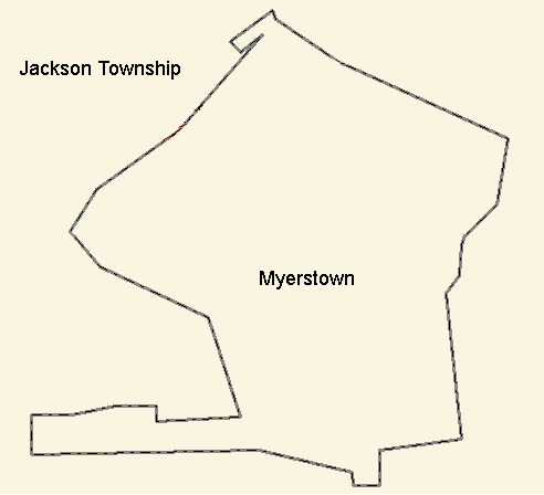
Myerstown is completely surrounded by Jackson Township.
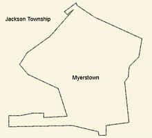 Border detail of Myerstown and surrounding municipality
Demographics
As of the census[2] of 2000, there were 3,171 people, 1,265 households, and 810 families residing in the borough. The population density was 3,559.1 people per square mile (1,375.7/km2). There were 1,339 housing units at an average density of 1,502.9 per square mile (580.9/km2). The racial makeup of the borough was 97.48% White, 1.45% African American, 0.00% Native American, 0.44% Asian, 0.00% Pacific Islander, 0.22% from other races, and 0.41% from two or more races. 0.95% of the population were Hispanic or Latino of any race.
There were 1,265 households out of which 29.6% had children under the age of 18 living with them, 50.4% were married couples living together, 9.5% had a female householder with no husband present, and 35.9% were non-families. 31.5% of all households were made up of individuals and 16.1% had someone living alone who was 65 years of age or older. The average household size was 2.33 and the average family size was 2.91.
In the borough the population was spread out with 22.2% under the age of 18, 7.0% from 18 to 24, 29.6% from 25 to 44, 19.2% from 45 to 64, and 22.0% who were 65 years of age or older. The median age was 38 years. For every 100 females there were 85.8 males. For every 100 females age 18 and over, there were 81.5 males.
The median income for a household in the borough was $36,563, and the median income for a family was $45,698. Males had a median income of $31,985 versus $20,684 for females. The per capita income for the borough was $17,177. 6.6% of the population and 4.6% of families were below the poverty line. 8.4% of those under the age of 18 and 9.5% of those 65 and older were living below the poverty line.
References
- ^ "US Gazetteer files: 2010, 2000, and 1990". United States Census Bureau. 2011-02-12. http://www.census.gov/geo/www/gazetteer/gazette.html. Retrieved 2011-04-23.
- ^ "American FactFinder". United States Census Bureau. http://factfinder.census.gov. Retrieved 2008-01-31.
Municipalities and communities of Lebanon County, Pennsylvania City 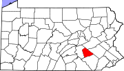
Boroughs Townships Annville | Bethel | Cold Spring | East Hanover | Heidelberg | Jackson | Millcreek | North Annville | North Cornwall | North Lebanon | North Londonderry | South Annville | South Lebanon | South Londonderry | Swatara | Union | West Cornwall | West Lebanon
CDPs Unincorporated
communitiesKleinfeltersville | Ono | Union Water Works | Waldeck
Categories:- Populated places established in 1763
- Boroughs in Lebanon County, Pennsylvania


Wikimedia Foundation. 2010.