- Cornwall, Pennsylvania
-
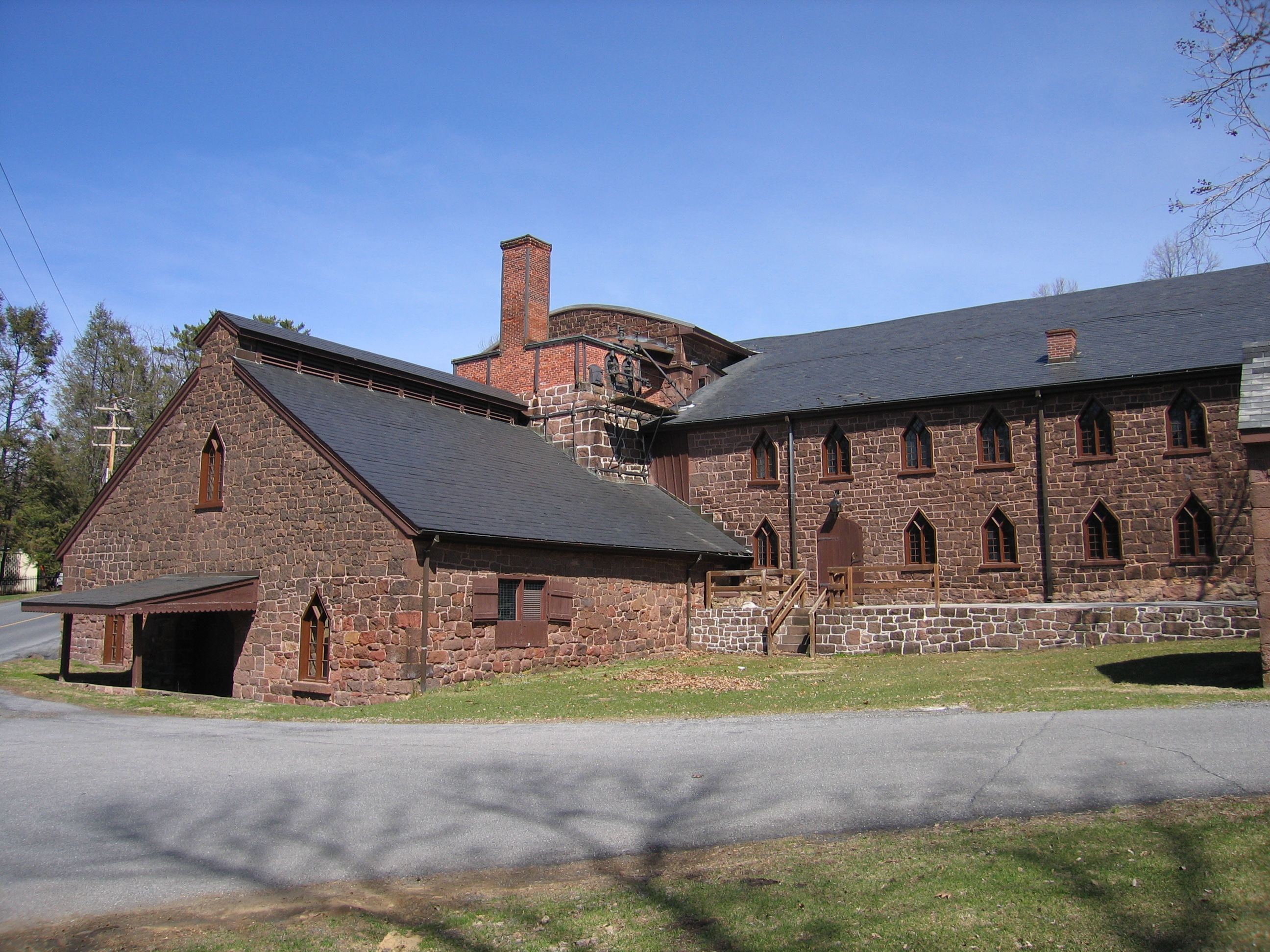
Cornwall, Pennsylvania — Borough — Cornwall Iron Furnace

 Cornwall, Pennsylvania
Coordinates: 40°16′23″N 76°24′38″W / 40.27306°N 76.41056°WCoordinates: 40°16′23″N 76°24′38″W / 40.27306°N 76.41056°W Country United States State Pennsylvania County Lebanon Settled 1737 Incorporated 1926 Government – Type Borough Council – Council President Carl Hilton (R) Area – Total 9.9 sq mi (25.6 km2) Elevation 554 ft (169 m) Population (2000) – Total 3,486 – Density 357.2/sq mi (137.9/km2) Time zone Eastern (EST) (UTC-5) – Summer (DST) EDT (UTC-4) Zip code Area code(s) 717 Cornwall is a borough in Lebanon County, Pennsylvania, United States. It is part of the Lebanon, PA Metropolitan Statistical Area. The population was 3,486 at the 2000 census.
Contents
History
Cornwall was founded by Peter Grubb in 1737. Peter, a Chester County stonemason, came to Lancaster County around 1734 in search of building materials. First building his house and then a store, he discovered very high quality magnetite iron ore nearby and decided to mine for it, acquiring 300 acres (1.2 km2) by 1737 and over 1,000 acres (4.0 km2) by 1739 when mining was initiated. He called it the Cornwall Iron Mines after his father's birthplace in Cornwall, England. The Cornwall Iron Mines, also known as Cornwall Banks, turned out to be the largest United States' iron deposit east of Lake Superior, and were once the largest open-pit iron mine in the world. They were mined continuously until 1973, totaling 234 uninterrupted years of production.
Finding the necessary components nearby for making iron (water, limestone and timber for charcoal), Grubb built the Cornwall Iron Furnace and began production in 1742. The operation also included the Hopewell Forges on nearby Hammer Creek. Peter Grubb did not stay long to run the operation, but leased it out in 1745 for 20 years and returned to Wilmington, Delaware. In 1765 Peter's sons Curtis and Peter Jr. took over the operation, and in 1798 it passed to Robert Coleman and his family. Cornwall Furnace was in production from 1742 until 1883, and appears today much as it was when production ended. In 1932 the Coleman family deeded the property to the Commonwealth of Pennsylvania and it is now a designated National Historic Landmark open to the public.[1]
Eventually the whole town became known as Cornwall. It was incorporated as a township on October 11, 1926 after having been a part of Lancaster County and for a while of Dauphin County.
Geography
Cornwall is located at 40°16′23″N 76°24′38″W / 40.27306°N 76.41056°W (40.273192, -76.410667)[2].
According to the United States Census Bureau, the borough has a total area of 9.9 square miles (26 km2), of which, 9.8 square miles (25 km2) of it is land and 0.1 square miles (0.26 km2) of it (1.11%) is water.
Demographics
As of the census[3] of 2000, there were 3,486 people, 1,210 households, and 965 families residing in the borough. The population density was 357.2 people per square mile (137.9/km²). There were 1,261 housing units at an average density of 129.2 per square mile (49.9/km²). The racial makeup of the borough was 97.79% White, 0.34% African American, 0.20% Native American, 1.06% Asian, 0.32% from other races, and 0.29% from two or more races. Hispanic or Latino of any race were 0.75% of the population.
There were 1,210 households out of which 32.6% had children under the age of 18 living with them, 71.9% were married couples living together, 4.4% had a female householder with no husband present, and 20.2% were non-families. 17.5% of all households were made up of individuals and 9.1% had someone living alone who was 65 years of age or older. The average household size was 2.58 and the average family size was 2.91.
In the borough the population was spread out with 20.9% under the age of 18, 4.9% from 18 to 24, 22.7% from 25 to 44, 28.1% from 45 to 64, and 23.5% who were 65 years of age or older. The median age was 46 years. For every 100 females there were 89.7 males. For every 100 females age 18 and over, there were 82.9 males.
The median income for a household in the borough was $59,550, and the median income for a family was $66,964. Males had a median income of $44,926 versus $28,125 for females. The per capita income for the borough was $27,904. About 1.1% of families and 1.7% of the population were below the poverty line, including 1.0% of those under age 18 and 4.2% of those age 65 or over.
References
- ^ Dieffenbach, Susan (2003). Cornwall Iron Furnace, Pennsylvania Trail of History Guide. Stackpole Books.
- ^ "US Gazetteer files: 2010, 2000, and 1990". United States Census Bureau. 2011-02-12. http://www.census.gov/geo/www/gazetteer/gazette.html. Retrieved 2011-04-23.
- ^ "American FactFinder". United States Census Bureau. http://factfinder.census.gov. Retrieved 2008-01-31.
Municipalities and communities of Lebanon County, Pennsylvania City 
Boroughs Townships Annville | Bethel | Cold Spring | East Hanover | Heidelberg | Jackson | Millcreek | North Annville | North Cornwall | North Lebanon | North Londonderry | South Annville | South Lebanon | South Londonderry | Swatara | Union | West Cornwall | West Lebanon
CDPs Unincorporated
communitiesKleinfeltersville | Ono | Union Water Works | Waldeck
Categories:- Populated places established in 1737
- Boroughs in Lebanon County, Pennsylvania


Wikimedia Foundation. 2010.