- Maltby le Marsh
-
Coordinates: 53°18′37″N 0°12′01″E / 53.310275°N 0.20024501°E
Maltby le Marsh 
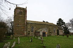
All Saints, Maltby le Marsh
 Maltby le Marsh shown within Lincolnshire
Population 364 (2001) OS grid reference TF466815 District East Lindsey Shire county Lincolnshire Region East Midlands Country England Sovereign state United Kingdom Postcode district LN13 Police Lincolnshire Fire Lincolnshire Ambulance East Midlands EU Parliament East Midlands UK Parliament Louth and Horncastle List of places: UK • England • Lincolnshire Maltby le Marsh is a village in Lincolnshire, England, between Alford and Mablethorpe. The village is at the junction of the A1104 and the A157.
The village has a shop, a newsagent and a post office, Maltby Service Station (petrol station), Oham (fishing lakes), the Crown Inn, and the Turks Head (both pubs).
The tower mill is disused and the sails have been removed, but the brick base still survives. A post mill existed at one time, but all trace of this has now gone.
Formerly there was a 12th century Anglican church, a Baptist chapel and a Methodist chapel. The Anglican church is disused, but the village shares the church in Beesby. The Baptist chapel has been converted into a house. The village hall, which is shared with Strubby and Beesby, was converted from the Methodist chapel.
External links
Maps and aerial photos
Categories:- Villages in Lincolnshire
- Civil parishes in Lincolnshire
Wikimedia Foundation. 2010.

