- Parkdale, Oregon
Infobox Settlement
official_name = Parkdale, Oregon
settlement_type = CDP
nickname =
motto =
imagesize =
image_caption =
image_
imagesize =
image_caption =
image_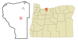
mapsize = 250x200px
map_caption = Location of Parkdale, Oregon
mapsize1 =
map_caption1 =subdivision_type = Country
subdivision_name =United States
subdivision_type1 = State
subdivision_name1 =Oregon
subdivision_type2 = County
subdivision_name2 = Hood Rivergovernment_footnotes =
government_type =
leader_title =
leader_name =
leader_title1 =
leader_name1 =
established_title =
established_date =unit_pref = Imperial
area_footnotes =area_magnitude =
area_total_km2 = 1.6
area_land_km2 = 1.6
area_water_km2 = 0.0
area_total_sq_mi = 0.6
area_land_sq_mi = 0.6
area_water_sq_mi = 0.0population_as_of = 2000
population_footnotes =
population_total = 266
population_density_km2 = 161.8
population_density_sq_mi = 419.1timezone = Pacific (PST)
utc_offset = -8
timezone_DST = PDT
utc_offset_DST = -7
elevation_footnotes =
elevation_m = 526
elevation_ft = 1726
latd = 45 |latm = 31 |lats = 1 |latNS = N
longd = 121 |longm = 35 |longs = 49 |longEW = Wpostal_code_type =
ZIP code
postal_code = 97041
area_code = 541
blank_name = FIPS code
blank_info = 41-56500GR|2
blank1_name = GNIS feature ID
blank1_info = 1147441GR|3
website =
footnotes =Parkdale is an unincorporated community in Hood River County,
Oregon ,United States . For statistical purposes, theUnited States Census Bureau has defined Parkdale as acensus-designated place (CDP). The census definition of the area may not precisely correspond to local understanding of the area with the same name. As of the 2000 census, the population was 266.History
Parkdale was founded by David Eccles and R. J. McIsaac in 1910 to serve as a terminus for the
Mount Hood Railroad .Geography
Parkdale is located at coor dms|45|31|1|N|121|35|49|W|city (45.516976, -121.596923)GR|1.
According to the
United States Census Bureau , the CDP has a total area of 0.6square mile s (1.6km² ), all of it land.Geology
The geology of Parkdale is dominated by the geology of
Mount Hood , a nearbystratovolcano about 8 miles to the south of the town. A six-thousand year old [http://vulcan.wr.usgs.gov/Volcanoes/PacificNW/AGU-T106/hood.html] lava flow is named after the town. It flowed north from the Upper Hood River Valley.Demographics
As of the
census GR|2 of 2000, there were 266 people, 88 households, and 68 families residing in the CDP. Thepopulation density was 419.1 people per square mile (163.0/km²). There were 92 housing units at an average density of 145.0/sq mi (56.4/km²). The racial makeup of the CDP is 80.08% White, 4.51% Native American, 0.75% Asian, 11.65% from other races, and 3.01% from two or more races. Hispanic or Latino of any race were 23.31% of the population.There were 88 households out of which 43.2% had children under the age of 18 living with them, 58.0% were married couples living together, 10.2% had a female householder with no husband present, and 22.7% were non-families. 15.9% of all households were made up of individuals and 4.5% had someone living alone who was 65 years of age or older. The average household size was 2.95 and the average family size was 3.21.
In the CDP the population was spread out with 30.5% under the age of 18, 10.2% from 18 to 24, 26.7% from 25 to 44, 21.8% from 45 to 64, and 10.9% who were 65 years of age or older. The median age was 34 years. For every 100 females there were 133.3 males. For every 100 females age 18 and over, there were 122.9 males.
The median income for a household in the CDP was $31,786, and the median income for a family was $34,375. Males had a median income of $52,679 versus $30,313 for females. The
per capita income for the CDP was $18,091. About 8.0% of families and 19.7% of the population were below thepoverty line , including 33.3% of those under the age of eighteen and none of those sixty five or over.ee also
*
Mount Hood Parkdale, Oregon References
Wikimedia Foundation. 2010.