- Adair Village, Oregon
Infobox Settlement
official_name = Adair Village, Oregon
settlement_type =City
nickname =
motto = Grounded in history, growing for the future.
imagesize =
image_caption =
image_
imagesize =
image_caption =
image_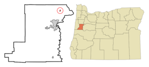
mapsize = 250px
map_caption = Location inOregon
mapsize1 =
map_caption1 =
subdivision_type = Country
subdivision_name =United States
subdivision_type1 = State
subdivision_name1 =Oregon
subdivision_type2 = County
subdivision_name2 = Benton
government_type =
leader_title =Mayor
leader_name = William (Bill) Currier
established_title = Incorporated
established_date = 1976
area_magnitude =
area_total_sq_mi = 0.2
area_total_km2 = 0.6
area_land_sq_mi = 0.2
area_land_km2 = 0.6
area_water_sq_mi = 0
area_water_km2 = 0
area_urban_sq_mi =
area_urban_km2 =
area_metro_sq_mi =
area_metro_km2 =
population_as_of = 2000
population_note =
population_total = 536
population_metro =
population_urban =
population_density_km2 = 862.3
population_density_sq_mi = 2250.3
timezone = Pacific
utc_offset = -8
timezone_DST = Pacific
utc_offset_DST = -7
latd = 44 |latm = 40 |lats = 25 |latNS = N
longd = 123 |longm = 13 |longs = 4 |longEW = W
elevation_m = 99.97
elevation_ft = 328
website = [http://www.cityofadairvillage.org/ www.cityofadairvillage.org]
postal_code_type =ZIP code
postal_code = 97330
area_code = 541
blank_name = FIPS code
blank_info = 41-00275GR|2
blank1_name = GNIS feature ID
blank1_info = 1130192GR|3
footnotes =Adair Village is a city in Benton County,
Oregon ,United States . The population was 536 at the 2000 census, and 930 residents as of 2007 estimate. [http://www.pdx.edu/media/p/r/prcCertifiedRelease_07_web_cities.pdf Population Research Center: 2007 Estimates.] Portland State University. Retrieved on August 28, 2008.] It is part of the "Corvallis, Oregon Metropolitan Statistical Area ".History
Adair Village was named after the
World War II military installationCamp Adair . When the war ended, the camp was closed and most of the buildings removed, except for the hospital, which in 1946 was leased toOregon State University for student and faculty housing. The university converted the hospital into apartments, a local government was organized, and Adair Village post office established in 1947. When the postwar enrollment boom dwindled, Oregon State gave up its lease, and theUnited States Air Force maintained the base as aradar station. Adair Village post office closed in 1951, andAdair Air Force Station post office took its place from 1961-1969. The Air Force ceased operations and sold the property, with the individual houses being placed on the market. Adair Village incorporated in 1976. Adair Village city hall is one of the original World War II buildings.cite book
last = McArthur
first = Lewis A.
authorlink = Lewis A. McArthur
coauthors =Lewis L. McArthur
title =Oregon Geographic Names
origyear = 1928
edition = Seventh Edition
year = 2003
publisher =Oregon Historical Society Press
location = Portland,Oregon
id = ISBN 0-87595-277-1
pages = 6-7]Geography
According to the
United States Census Bureau , the city has a total area of 0.2square mile s (0.6km² ), all of it land.Demographics
As of the
census GR|2 of 2000, there were 536 people, 170 households, and 140 families residing in the city. Thepopulation density was 2,250.3 people per square mile (862.3/km²). There were 180 housing units at an average density of 755.7/sq mi (289.6/km²). The racial makeup of the city was 87.87% White, 0.75% African American, 2.43% Native American, 1.31% Asian, 1.49% Pacific Islander, 1.12% from other races, and 5.04% from two or more races. Hispanic or Latino of any race were 4.48% of the population.There were 170 households out of which 52.4% had children under the age of 18 living with them, 64.1% were married couples living together, 12.9% had a female householder with no husband present, and 17.1% were non-families. 11.2% of all households were made up of individuals and 2.4% had someone living alone who was 65 years of age or older. The average household size was 3.15 and the average family size was 3.40.In the city the population was spread out with 35.4% under the age of 18, 9.5% from 18 to 24, 32.8% from 25 to 44, 19.0% from 45 to 64, and 3.2% who were 65 years of age or older. The median age was 28 years. For every 100 females there were 98.5 males. For every 100 females age 18 and over, there were 87.0 males.
The median income for a household in the city was $49,000, and the median income for a family was $51,667. Males had a median income of $38,750 versus $29,286 for females. The
per capita income for the city was $16,311. About 6.4% of families and 9.0% of the population were below thepoverty line , including 9.8% of those under age 18 and none of those age 65 or over.ites of interest
The
Oregon Department of Fish and Wildlife -administeredE. E. Wilson Wildlife Area forms the northern border of the city.References
External links
* [http://www.cityofadairvillage.org/ City of Adair Village]
* [http://bluebook.state.or.us/local/cities/ad/adair.htm Oregon Blue Book entry for Adair Village]
Wikimedia Foundation. 2010.