- Mooreland, Oklahoma
-
Mooreland, Oklahoma — Town — Location of Mooreland, Oklahoma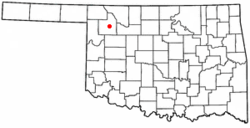
Coordinates: 36°26′15″N 99°12′20″W / 36.4375°N 99.20556°WCoordinates: 36°26′15″N 99°12′20″W / 36.4375°N 99.20556°W Country United States State Oklahoma County Woodward Area – Total 0.8 sq mi (2.1 km2) – Land 0.8 sq mi (2.1 km2) – Water 0.0 sq mi (0.0 km2) Elevation 1,893 ft (577 m) Population (2010) – Total 1,190 – Density 1,487.5/sq mi (566.7/km2) Time zone Central (CST) (UTC-6) – Summer (DST) CDT (UTC-5) ZIP code 73852 Area code(s) 580 FIPS code 40-49250[1] GNIS feature ID 1095500[2] Mooreland is a town in Woodward County, Oklahoma, United States. The population was 1,190 at the 2010 census.
Contents
Geography
Mooreland is located at 36°26′15″N 99°12′20″W / 36.4375°N 99.20556°W (36.437517, -99.205420)[3].
According to the United States Census Bureau, the town has a total area of 0.8 square miles (2.1 km2), all of it land.
Demographics
Historical populations Census Pop. %± 1920 592 — 1940 811 — 1970 1,196 — 2000 1,226 — 2010 1,190 −2.9% As of the census[1] of 2000, there were 1,226 people, 477 households, and 336 families residing in the town. The population density was 1,484.9 people per square mile (570.3/km²). There were 554 housing units at an average density of 671.0 per square mile (257.7/km²). The racial makeup of the town was 95.02% White, 2.37% Native American, 0.08% Asian, 1.88% from other races, and 0.65% from two or more races. Hispanic or Latino of any race were 3.83% of the population.
There were 477 households out of which 34.2% had children under the age of 18 living with them, 56.8% were married couples living together, 10.7% had a female householder with no husband present, and 29.4% were non-families. 27.5% of all households were made up of individuals and 15.7% had someone living alone who was 65 years of age or older. The average household size was 2.47 and the average family size was 2.99.
In the town the population was spread out with 27.6% under the age of 18, 5.7% from 18 to 24, 23.8% from 25 to 44, 20.9% from 45 to 64, and 22.0% who were 65 years of age or older. The median age was 40 years. For every 100 females there were 82.2 males. For every 100 females age 18 and over, there were 80.9 males.
The median income for a household in the town was $31,680, and the median income for a family was $38,654. Males had a median income of $28,906 versus $21,574 for females. The per capita income for the town was $16,657. About 9.0% of families and 10.4% of the population were below the poverty line, including 15.0% of those under age 18 and 2.7% of those age 65 or over.
Primary Employers are Mooreland Public Schools & Western Farmers Electric Cooperative, as well as Prather Cues.
Notable people
- Elizabeth Kenny, Miss Oklahoma 2004
- Troy Ruttman, Indianapolis 500 winner 1952
- Joyce Eilers Bacak, composer and music educator [1]
References
- ^ a b "American FactFinder". United States Census Bureau. http://factfinder.census.gov. Retrieved 2008-01-31.
- ^ "US Board on Geographic Names". United States Geological Survey. 2007-10-25. http://geonames.usgs.gov. Retrieved 2008-01-31.
- ^ "US Gazetteer files: 2010, 2000, and 1990". United States Census Bureau. 2011-02-12. http://www.census.gov/geo/www/gazetteer/gazette.html. Retrieved 2011-04-23.
External links
Municipalities and communities of Woodward County, Oklahoma City 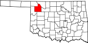
Towns Fort Supply | Mooreland | Mutual | Sharon
Unincorporated
communitiesQuinlan | Tangier
Categories:- Towns in Oklahoma
- Populated places in Woodward County, Oklahoma


Wikimedia Foundation. 2010.