- Cortland, Ohio
-
Cortland, Ohio — City — Nickname(s): 8- -8 8-8- Location of Cortland in Ohio
Coordinates: 41°19′50″N 80°43′18″W / 41.33056°N 80.72167°WCoordinates: 41°19′50″N 80°43′18″W / 41.33056°N 80.72167°W Country United States State Ohio County Trumbull Government – Mayor Curt Moll Area – Total 4.48 sq mi (11.6 km2) – Land 4.48 sq mi (11.6 km2) – Water 0 sq mi (0.0 km2) Elevation 1,024 ft (312 m) Population (2000)[1] – Total 6,830 – Density 1,524.5/sq mi (588.6/km2) Time zone EST (UTC-5) – Summer (DST) EDT (UTC-4) ZIP code 44410 Area code(s) 330 FIPS code 39-18812[2] GNIS feature ID 1056839[3] Website http://www.cityofcortland.org  Mosquito Creek Reservoir at Cortland, Ohio. Cortland is just off to the right of the picture. View is to the north.
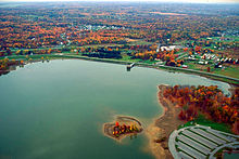 Mosquito Creek Reservoir at Cortland, Ohio. Cortland is just off to the left of the picture. View is to the south.
Cortland is a city in Trumbull County, Ohio, United States located on the eastern shore of Mosquito Creek Reservoir. Walnut Run is the creek that runs through town. The population was 6,830 at the 2000 census. It is part of the Youngstown-Warren-Boardman, OH-PA Metropolitan Statistical Area. Cortland became a village in 1874 with the construction of a railroad depot. It became a city in 1980 when its population exceeded 5,000 people.
The area was once known as Baconsburg, after Samuel Bacon, who built a sawmill and several buildings in the area during the early 19th century.
Cortland's school district is known as Lakeview. It has one elementary school, one middle school, and one high school (Lakeview High School).
The current mayor of Cortland is Curt Moll. Past mayors include Melissa Long and Sandra Roscoe. Famous nature/wildlife photographer, Ron Bierworth used to live there.
Demographics
As of 2000, there were 6,830 people, 2,738 households, and 1,968 families residing in the city. The population density was 1,524.8 people per square mile (588.6/km²). There were 2,899 housing units at an average density of 647.2 per square mile (249.8/km²). The racial makeup of the city was 97.61% White, 0.94% African American, 0.12% Native American, 0.38% Asian, 0.12% from other races, and 0.83% from two or more races. Hispanic or Latino of any race were 0.75% of the population.
There were 2,738 households out of which 32.6% had children under the age of 18 living with them, 59.5% were married couples living together, 10.0% had a female householder with no husband present, and 28.1% were non-families. 24.3% of all households were made up of individuals and 10.6% had someone living alone who was 65 years of age or older. The average household size was 2.48 and the average family size was 2.97.
In the city the population was spread out with 24.6% under the age of 18, 7.4% from 18 to 24, 26.5% from 25 to 44, 27.9% from 45 to 64, and 13.5% who were 65 years of age or older. The median age was 40 years. For every 100 females there were 90.0 males. For every 100 females age 18 and over, there were 85.5 males.
The median income for a household in the city was $50,941 and the median income for a family was $62,441. Males had a median income of $50,739 versus $28,320 for females. The per capita income for the city was $22,972. About 4.6% of families and 5.3% of the population were below the poverty line, including 6.3% of those under age 18 and 3.0% of those age 65 or over.
References
- ^ US Census 2000
- ^ "American FactFinder". United States Census Bureau. http://factfinder.census.gov. Retrieved 2008-01-31.
- ^ "US Board on Geographic Names". United States Geological Survey. 2007-10-25. http://geonames.usgs.gov. Retrieved 2008-01-31.
External links
Municipalities and communities of Trumbull County, Ohio Cities Cortland | Girard | Hubbard | Newton Falls | Niles | Warren | Youngstown‡

Villages Townships Bazetta | Bloomfield | Braceville | Bristol | Brookfield | Champion | Farmington | Fowler | Greene | Gustavus | Hartford | Howland | Hubbard | Johnston | Kinsman | Liberty | Newton Falls | Mecca | Mesopotamia | Newton | Southington | Vernon | Vienna | Warren | Weathersfield
CDPs Unincorporated
communitiesBristolville | Burghill | Center of the World | Farmdale | Fowler | Hartford | Kinsman | North Bloomfield | Southington
Footnotes ‡This populated place also has portions in an adjacent county or counties
Categories:- Cities in Ohio
- Populated places in Trumbull County, Ohio
- Youngstown metropolitan area
- Populated places established in 1874


Wikimedia Foundation. 2010.