- Mount Clark (California)
-
Mount Clark 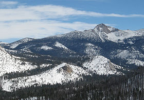
West face from Glacier Point Road, January 2008.Elevation 11,527 ft (3,513 m) [1][2] Prominence 722 ft (220 m) [2] Parent peak Gray Peak[3] Listing SPS Mountaineer's peak[4] Location Location Yosemite National Park, Mariposa County, California, USA Range Clark Range Coordinates 37°41′47″N 119°25′43″W / 37.6963183°N 119.4284859°WCoordinates: 37°41′47″N 119°25′43″W / 37.6963183°N 119.4284859°W[5] Topo map USGS Merced Peak Climbing First ascent 1866 by Clarence King and James T. Gardiner[6] Easiest route Rock climb, class 4[7] Mount Clark is an 11,527 feet (3,513 m) tall granite peak in the Clark Range. It is a popular destination for mountaineering.
It is named for Galen Clark, an early explorer and the first guardian of Yosemite National Park. The Clark Range, also named for Galen Clark, is a sub-range of the Sierra Nevada. Before it was given its present name, it was known as Gothic Peak and then The Obelisk, the name used by the Whitney Survey.[8] Obelisk Lake, at 9,853 feet (3,003 m) lies on the mountain's northeast flank.
References
- ^ The NGVD 29 elevation of 11,522 feet was converted using VERTCON to the NAVD 88 elevation of 11,527 feet.
- ^ a b "Mount Clark". Peakbagger.com. http://www.peakbagger.com/peak.aspx?pid=2638. Retrieved 2011-05-05.
- ^ "Mount Clark". LoJ.com. http://listsofjohn.com/PeakStats/Climbers.php?Id=56062. Retrieved 2011-05-31.
- ^ "Sierra Peaks Section List". Angeles Chapter, Sierra Club. http://angeles.sierraclub.org/sps/spslist.pdf. Retrieved 2009-08-09.
- ^ "Mount Clark". Geographic Names Information System, U.S. Geological Survey. http://geonames.usgs.gov/pls/gnispublic/f?p=gnispq:3:::NO::P3_FID:254748. Retrieved 2009-08-09.
- ^ Farquhar, Francis P. (1926). Place Names of the High Sierra. San Francisco: Sierra Club. http://www.yosemite.ca.us/library/place_names_of_the_high_sierra/c.html.
- ^ Secor, R.J. (1999). The High Sierra: Peaks, Passes and Trails (2nd ed.). Seattle: The Mountaineers Books. pp. 388–390. ISBN 0-89886-625-1.
- ^ Browning, Peter (1986). Place Names of the Sierra Nevada. Berkley: Wilderness Press. p. 40. ISBN 978-0-89997-119-3.
External links
- "Mount Clark". SummitPost.org. http://www.summitpost.org/page/150527. Retrieved 2008-01-27.
- "Mountaineering in the Sierra Nevada by Clarence King, Chapter IX - Merced Ramblings 1866". Yosemite Online Library. http://www.yosemite.ca.us/library/mountaineering_in_the_sierra_nevada/09.html#page_244. Retrieved 2011-01-23.
Categories:- Mountains of Yosemite National Park
- Mountains of Mariposa County, California
- United States National Park Service stubs
- Mariposa County, California geography stubs
Wikimedia Foundation. 2010.