- Clark Range (California)
-
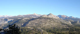
Clark Range Range Clark Range from the north, November 2005Country United States Region California Part of Sierra Nevada Coordinates 37°39′29.754″N 119°24′33.535″W / 37.658265°N 119.40931528°W Highest point Merced Peak - elevation 11,726 ft (3,574 m) - coordinates 37°43′0″N 119°22′12″W / 37.716667°N 119.37°W Geology Metamorphic, Igneous The Clark Range is a subrange of California's Sierra Nevada in Yosemite National Park.[1]
Geography
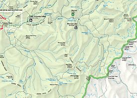
The range extends in a north-south direction from Quarzite Peak (37°43.0′N 119°25.5′W / 37.717°N 119.425°W) to Triple Divide Peak (37°38.0′N 119°22.2′W / 37.633°N 119.37°W) and separates the drainage basins of the Illilouette Creek from the uppermost portions of the Merced River. The range is named after Mount Clark, which was named after Galen Clark.
The highest peak in the range is Merced Peak at 11,726 feet (3,574 m).[2]
Geology
Metamorphic rock composes most of the Clark Range, with the granite of Mount Clark's summit being the main exception.[3]
References
- ^ "Clark Range". Geographic Names Information System, U.S. Geological Survey. http://geonames.usgs.gov/pls/gnispublic/f?p=gnispq:3:::NO::P3_FID:1658284. Retrieved 2009-05-03.
- ^ "Merced Peak, California". Peakbagger.com. http://www.peakbagger.com/peak.aspx?pid=2640. Retrieved 2008-01-27.
- ^ Secor, R.J.. The High Sierra: Peaks, Passes and Trails (2nd ed.). Seattle: The Mountaineers Books. p. 378. ISBN 0-89886-625-1.
Categories:- Landforms of Yosemite National Park
- Mountain ranges of Madera County, California
- United States National Park Service stubs
Wikimedia Foundation. 2010.


