Milner Pass

Milner Pass
Milner Pass
Elevation 10,758 ft (3,279 m) [1]
Traversed by US 34
Location
Location Grand / Larimer counties, Colorado, USA
Range Front Range
Coordinates 40°25′11″N 105°48′41″W / 40.41972°N 105.81139°W / 40.41972; -105.81139Coordinates: 40°25′11″N 105°48′41″W / 40.41972°N 105.81139°W / 40.41972; -105.81139[1]
Topo map USGS Fall River Pass

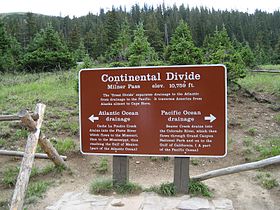
Milner Pass, elevation 10,758 ft (3,279 m)[1] is a mountain pass in the Rocky Mountains of northern Colorado in the United States. It is located on the continental divide in the Front Range, within Rocky Mountain National Park, along the boundary between Larimer and Grand counties. The pass provides the passage over the continental divide for US 34, also known as Trail Ridge Road between Estes Park and Granby. The pass is not, however, the high point on Trail Ridge Road, which crests at 12,183 ft (3,713 m)[2] east of the pass within Rocky Mountain National Park. Along with the rest of Trail Ridge Road, the pass is generally closed in winter from the first heavy snow fall (usually October) until the opening of the road around Memorial Day. The gentle pass divides the headwaters of the Cache la Poudre River (which issues from Poudre Lake just east of the pass) and several creeks near the headwaters of the Colorado River to the west. The road near the pass provides a panoramic view of the Never Summer Mountains to the west.[2]

References


Wikimedia Foundation. 2010.

Игры ⚽ Нужен реферат?

Look at other dictionaries:

  • Milner Pass Road Camp Mess Hall and House — U.S. National Register of Historic Places …   Wikipedia

  • Milner — may refer to: Contents 1 People 2 Places 3 Other uses 4 See also People Alfred Milner, 1st Viscount Milner (1854–1 …   Wikipedia

  • National Register of Historic Places listings in Rocky Mountain National Park — This is a list of the National Register of Historic Places listings in Rocky Mountain National Park. This is intended to be a complete list of the properties and districts on the National Register of Historic Places in Rocky Mountain National… …   Wikipedia

  • National Register of Historic Places listings in Grand County, Colorado — Location of Grand County in Colorado This is a list of the National Register of Historic Places listings in Grand County, Colorado. This is intended to be a complete list of the properties and districts on the National Register of Historic Places …   Wikipedia

  • List of mountain passes — This is a list of mountain passes. Africa *Halfaya Pass *Moteng Pass (Lesotho) *Mahlasela pass (Lesotho)Asia* Khunjerab Pass Pakistan China (highest international border crossing at 4693 m.) * Khyber Pass Pakistan Afghanistan * Kotal e Lataband * …   Wikipedia

  • Colorado mountain passes — The following tables list some important mountain passes in the Rocky Mountains of the U.S. State of Colorado. Contents 1 High elevation Colorado highways not on a pass 2 Colorado mountain passes traversed by paved highways 3 …   Wikipedia

  • Southern Rocky Mountains — Range Mount Elbert is the highest peak of the Southern Rocky Mountains …   Wikipedia

  • Trail Ridge Road — Infobox road marker state=CO type=US route=34 alternate name=Trail Ridge Road maint= section= length mi=48 length round= length ref= length notes= established=1932 direction a=West terminus a=Grand Lake direction b=East terminus b=Estes Park… …   Wikipedia

  • Middle Park (Colorado basin) — View of Middle Park near Granby, Colorado Middle Park (elev. 8000 ft/2500 m) is a high basin in the Rocky Mountains of north central Colorado in the United States. It is located in Grand County, on the southwest slope of Rocky Mountain National… …   Wikipedia

  • Middle Park — près de Granby,dans le Colorado Middle Park est un bassin d altitude (2 500 m) dans les montagnes Rocheuses dans la région centrale du nord du Colorado aux États Unis. Il est situé dans le comté de Grand, sur le versant sud ouest du… …   Wikipédia en Français

Share the article and excerpts

Direct link
Do a right-click on the link above
and select “Copy Link”