- Marion Township, Clinton County, Ohio
-
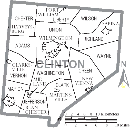
Marion Township, Ohio — Township — Municipalities and townships of Clinton County.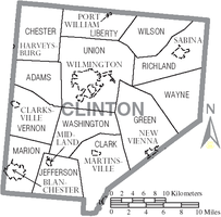
Coordinates: 39°17′37″N 83°58′33″W / 39.29361°N 83.97583°WCoordinates: 39°17′37″N 83°58′33″W / 39.29361°N 83.97583°W Country United States State Ohio County Clinton Area – Total 25.5 sq mi (65.9 km2) – Land 25.4 sq mi (65.8 km2) – Water 0.1 sq mi (0.1 km2) Elevation[1] 958 ft (292 m) Population (2000) – Total 5,489 – Density 216.1/sq mi (83.4/km2) Time zone Eastern (EST) (UTC-5) – Summer (DST) EDT (UTC-4) FIPS code 39-47670[2] GNIS feature ID 1085882[1] Marion Township is one of the thirteen townships of Clinton County, Ohio, United States. The 2000 census found 5,489 people in the township, 1,269 of whom lived in the unincorporated portions of the township,[3] up from 5,186 in 1990.
Contents
Geography
Located in the southwest corner of the county, it borders the following townships:
- Vernon Township - north
- Washington Township - northeast
- Jefferson Township - east
- Perry Township, Brown County - south
- Wayne Township, Clermont County - southwest
- Harlan Township, Warren County - west
The entire township lies in the Virginia Military District.
Most of the village of Blanchester is located in western Marion Township.
Name and history
It is one of twelve Marion Townships statewide.[4]
Historic population figures
Year Marion Township Blanchester Village 1910 2,533 1,813 1920 2,324 1,676 1930 2,192 1,597 1940 2,404 1,785 1950 2,749 2,109 1960 3,853 2,944 1970 1,412 3,080 1980 2,107 3,207 1990 5,186 4,206 2000 5,489 4,220 Government
The township is governed by a three-member board of trustees, who are elected in November of odd-numbered years to a four-year term beginning on the following January 1. Two are elected in the year after the presidential election and one is elected in the year before it. There is also an elected township fiscal officer,[5] who serves a four-year term beginning on April 1 of the year after the election, which is held in November of the year before the presidential election. Vacancies in the fiscal officership or on the board of trustees are filled by the remaining trustees.
References
- Clinton County Historical Society. Clinton County, Ohio, 1982. Wilmington, Ohio: The Society, 1982.
- Ohio Atlas & Gazetteer. 6th ed. Yarmouth, Maine: DeLorme, 2001. ISBN 0-89933-281-1
- Ohio. Secretary of State. The Ohio municipal and township roster, 2002-2003. Columbus, Ohio: The Secretary, 2003.
- ^ a b "US Board on Geographic Names". United States Geological Survey. 2007-10-25. http://geonames.usgs.gov. Retrieved 2008-01-31.
- ^ "American FactFinder". United States Census Bureau. http://factfinder.census.gov. Retrieved 2008-01-31.
- ^ Clinton County, Ohio — Population by Places Estimates Ohio State University, 2007. Accessed 15 May 2007.
- ^ "Detailed map of Ohio" (PDF). United States Census Bureau. 2000. http://www2.census.gov/geo/maps/general_ref/cousub_outline/cen2k_pgsz/oh_cosub.pdf. Retrieved 2007-02-16.
- ^ §503.24, §505.01, and §507.01 of the Ohio Revised Code. Accessed 4/30/2009.
External links
Municipalities and communities of Clinton County, Ohio City 
Villages Blanchester‡ | Clarksville | Lynchburg‡ | Martinsville | Midland | New Vienna | Port William | Sabina
Townships Unincorporated
communitiesCuba | Lees Creek | Reesville
Footnotes ‡This populated place also has portions in an adjacent county or counties
Categories:- Townships in Clinton County, Ohio

Wikimedia Foundation. 2010.