- Hi-Nella, New Jersey
Infobox Settlement
official_name = Hi-Nella, New Jersey
settlement_type = Borough
nickname =
motto =
imagesize =
image_caption =
image_
imagesize =
image_caption =
image_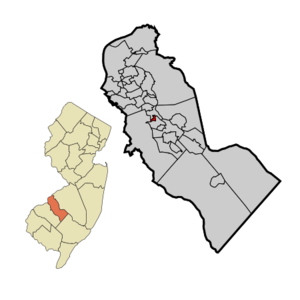
mapsize = 250x200px
map_caption = Hi-Nella highlighted in Camden County. Inset: Location of Camden County highlighted in the State of New Jersey.
mapsize1 = 250x200px
map_caption1 = Census Bureau map of Hi-Nella, New Jerseysubdivision_type = Country
subdivision_name =United States
subdivision_type1 = State
subdivision_name1 =New Jersey
subdivision_type2 = County
subdivision_name2 = Camden
government_footnotes =
government_type =Borough (New Jersey)
leader_title =Mayor
leader_name = Irene Murphy-Wolick
leader_title1 =
leader_name1 =
established_title = Incorporated
established_date =April 23 ,1929 unit_pref = Imperial
area_footnotes =
area_magnitude =
area_total_km2 = 0.6
area_land_km2 = 0.6
area_water_km2 = 0.0
area_total_sq_mi = 0.2
area_land_sq_mi = 0.2
area_water_sq_mi = 0.0population_as_of = 2006
population_footnotes =
population_total = 1007
population_density_km2 = 1751.7
population_density_sq_mi = 4536.9timezone = Eastern (EST)
utc_offset = -5
timezone_DST = EDT
utc_offset_DST = -4
elevation_footnotes = [Gnis|885256|Borough of Hi-Nella,Geographic Names Information System . AccessedJune 13 ,2008 .]
elevation_m = 15
elevation_ft = 49
latd = 39 |latm = 50 |lats = 07 |latNS = N
longd = 75 |longm = 01 |longs = 18 |longEW = Wpostal_code_type =
ZIP code
postal_code = 08083
area_code = 856
blank_name = FIPS code
blank_info = 34-32220GR|2 [ [http://mcdc2.missouri.edu/webrepts/commoncodes/ccc_nj.html A Cure for the Common Codes: New Jersey] , Missouri Census Data Center. AccessedJuly 14 ,2008 .]
blank1_name = GNIS feature ID
blank1_info = 0885256GR|3
website =
footnotes =Hi-Nella is a Borough in Camden County,
New Jersey ,United States . As of theUnited States 2000 Census , the borough population was 1,029.The Borough of Hi-Nella was created on
April 23 ,1929 , from Clementon Township, one of seven municipalities created from the now-defunct township, and one of five new municipalities (joining Lindenwold, Pine Hill, Pine Valley and Somerdale) created on that same date."The Story of New Jersey's Civil Boundaries: 1606-1968", John P. Snyder, Bureau of Geology and Topography; Trenton, New Jersey; 1969. p. 107.]Geography
Hi-Nella is located at coor dms|39|50|14|N|75|1|12|W|city (39.837163, -75.020002)GR|1.
According to the
United States Census Bureau , the borough has a total area of 0.2square mile s (0.6km² ), all of it land.Hi-Nella borders Gloucester Township, Somerdale, and Stratford.
Demographics
USCensusPop
1930= 160
1940= 203
1950= 237
1960= 474
1970= 1195
1980= 1250
1990= 1045
2000= 1029
estimate=1007
estyear=2006
estref= [http://factfinder.census.gov/servlet/SAFFPopulation?_event=Search&geo_id=16000US3428800&_geoContext=01000US%7C04000US34%7C16000US3428800&_street=&_county=hi-nella&_cityTown=hi-nella&_state=04000US34&_zip=&_lang=en&_sse=on&ActiveGeoDiv=geoSelect&_useEV=&pctxt=fph&pgsl=160&_submenuId=population_0&ds_name=null&_ci_nbr=null&qr_name=null®=null%3Anull&_keyword=&_industry= Census data for Hi-Nella borough] ,United States Census Bureau . AccessedSeptember 1 ,2007 .]
footnote=Population 1930 - 1990. [ [http://www.wnjpin.net/OneStopCareerCenter/LaborMarketInformation/lmi01/poptrd6.htm New Jersey Resident Population by Municipality: 1930 - 1990] , Workforce New Jersey Public Information Network. AccessedMarch 1 ,2007 .] As of thecensus GR|2 of 2000, there were 1,029 people, 472 households, and 260 families residing in the borough. Thepopulation density was 4,536.9 people per square mile (1,727.4/km²). There were 495 housing units at an average density of 2,182.5/sq mi (831.0/km²). The racial makeup of the borough was 71.04% White, 19.24% African American, 3.11% Asian, 4.37% from other races, and 2.24% from two or more races. Hispanic or Latino of any race were 6.90% of the population.There were 472 households out of which 28.0% had children under the age of 18 living with them, 31.6% were married couples living together, 16.3% had a female householder with no husband present, and 44.9% were non-families. 36.4% of all households were made up of individuals and 9.3% had someone living alone who was 65 years of age or older. The average household size was 2.18 and the average family size was 2.83.
In the borough the population was spread out with 25.0% under the age of 18, 10.5% from 18 to 24, 36.3% from 25 to 44, 14.5% from 45 to 64, and 13.7% who were 65 years of age or older. The median age was 32 years. For every 100 females there were 89.2 males. For every 100 females age 18 and over, there were 87.8 males.
The median income for a household in the borough was $34,948, and the median income for a family was $38,393. Males had a median income of $32,308 versus $25,759 for females. The
per capita income for the borough was $19,285. About 9.9% of families and 12.2% of the population were below thepoverty line , including 10.7% of those under age 18 and 6.3% of those age 65 or over.Government
Local government
Hi-Nella is governed under the Borough form of New Jersey municipal government. The government consists of a Mayor and a Borough Council comprising six council members, with all positions elected at large. A Mayor is elected directly by the voters to a four-year term of office. The Borough Council consists of six members elected to serve three-year terms on a staggered basis, with two seats coming up for election each year."2005 New Jersey Legislative District Data Book",
Rutgers University Edward J. Bloustein School of Planning and Public Policy , April 2005, p. 28.]Federal, state and county representation
Hi-Nella is in the First Congressional District and is part of New Jersey's 5th Legislative District. [ [http://www.lwvnj.org/pubs/CG06.pdf 2006 New Jersey Citizen's Guide to Government] , New Jersey
League of Women Voters , p. 58. AccessedAugust 30 ,2006 .]Education
Hi-Nella is a non-operating school district. For Kindergarten through eighth grade, public school students from Hi-Nella attend school in Oaklyn as part of a
sending/receiving relationship with theOaklyn Public School District . [ [http://www.oaklyn.k12.nj.us/AboutUs/BoardofEducation/tabid/1487/Default.aspx Board of Education] , Oaklyn Public School. AccessedJuly 8 ,2008 . "The Board of Education is a legislative body with powers defined by the state of New Jersey. The Board comprises nine residents of Oaklyn and one representative from Hi-Nella, our sending district."]For grades 9 - 12, public school students attend Sterling High School, a regional high school serving students from Magnolia, Somerdale, Stratford, along with the sending districts of Hi-Nella and Laurel Springs. [ [http://education.state.nj.us/rc/rc06/narrative/07/5035/07-5035-050.html Sterling High School 2006 Report Card Narrative] ,
New Jersey Department of Education . AccessedDecember 6 ,2007 . "Sterling High School District is a regional district serving Hi Nella, Laurel Springs, Magnolia, Somerdale and Stratford."] The high school is located in Somerdale. Prior to this agreement, Hi-Nella students attended Collingswood High School.Transportation
New Jersey Transit local bus service 451, 455 and 457 routes. [ [http://www.njtransit.com/sf_tp_rc_camden.shtml Camden County Bus/Rail Connections] ,New Jersey Transit . AccessedJune 21 ,2007 .]References
External links
* [http://www.oaklyn.k12.nj.us/ Oaklyn Public Schools]
*NJReportCard|07|3770|0|Oaklyn Public Schools
* [http://nces.ed.gov/ccd/schoolsearch/school_list.asp?Search=1&DistrictID=3411940 Data for the Oaklyn Public Schools] ,National Center for Education Statistics
* [http://www.sterling.k12.nj.us/ Sterling High School]
*NJReportCard|07|5035|050|Sterling High School
Wikimedia Foundation. 2010.