- Laurel Springs, New Jersey
Infobox Settlement
official_name = Laurel Springs, New Jersey
settlement_type = Borough
nickname =
motto =
imagesize =
image_caption =
image_
imagesize =
image_caption =
image_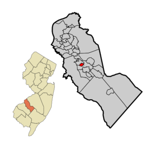
mapsize = 250x200px
map_caption = Laurel Springs highlighted in Camden County. Inset: Location of Camden County in the State of New Jersey.
mapsize1 = 250x200px
map_caption1 = Census Bureau map of Laurel Springs, New Jerseysubdivision_type = Country
subdivision_name =United States
subdivision_type1 = State
subdivision_name1 =New Jersey
subdivision_type2 = County
subdivision_name2 = Camden
government_footnotes =
government_type = Borough
leader_title =Mayor
leader_name = Jack Severson
leader_title1 =
leader_name1 =
established_title = Incorporated
established_date =April 2 ,1913 unit_pref = Imperial
area_footnotes =
area_magnitude =
area_total_km2 = 1.2
area_land_km2 = 1.2
area_water_km2 = 0.0
area_total_sq_mi = 0.5
area_land_sq_mi = 0.5
area_water_sq_mi = 0.0population_as_of = 2006
population_footnotes =
population_total = 1923
population_density_km2 = 1626.8
population_density_sq_mi = 4213.5timezone = Eastern (EST)
utc_offset = -5
timezone_DST = EDT
utc_offset_DST = -4
elevation_footnotes = [Gnis|885272|Borough of Laurel Springs,Geographic Names Information System . AccessedJune 13 ,2008 .]
elevation_m = 27
elevation_ft = 89
latd = 39 |latm = 49 |lats = 13 |latNS = N
longd = 75 |longm = 00 |longs = 20 |longEW = Wpostal_code_type =
ZIP code
postal_code = 08021
area_code = 856
blank_name = FIPS code
blank_info = 34-39210GR|2 [ [http://mcdc2.missouri.edu/webrepts/commoncodes/ccc_nj.html A Cure for the Common Codes: New Jersey] , Missouri Census Data Center. AccessedJuly 14 ,2008 .]
blank1_name = GNIS feature ID
blank1_info = 0885272GR|3
website = http://www.laurelsprings-nj.com
footnotes =Laurel Springs is a Borough in Camden County,
New Jersey ,United States . As of theUnited States 2000 Census , the borough population was 1,970.Laurel Springs was incorporated as a borough by an Act of the
New Jersey Legislature onApril 2 ,1913 , from portions of Clementon Township, based on the results of a referendum held onMay 1 ,1913 ."The Story of New Jersey's Civil Boundaries: 1606-1968", John P. Snyder, Bureau of Geology and Topography; Trenton, New Jersey; 1969. p. 107.]Geography
Laurel Springs is located at coor dms|39|49|20|N|75|0|15|W|city (39.822147, -75.004238)GR|1.
According to the
United States Census Bureau , the borough has a total area of 0.5square mile s (1.2km² ), all of it land.Laurel Springs borders Lindenwold and Stratford.
Demographics
USCensusPop
1930= 1343
1940= 1344
1950= 1540
1960= 2028
1970= 2566
1980= 2249
1990= 2341
2000= 1970
estimate=1923
estyear=2006
estref= [http://factfinder.census.gov/servlet/SAFFPopulation?_event=ChangeGeoContext&geo_id=16000US3439210&_geoContext=01000US%7C04000US34%7C16000US3432220&_street=&_county=laurel&_cityTown=laurel&_state=04000US34&_zip=&_lang=en&_sse=on&ActiveGeoDiv=geoSelect&_useEV=&pctxt=fph&pgsl=010&_submenuId=population_0&ds_name=null&_ci_nbr=null&qr_name=null®=null%3Anull&_keyword=&_industry= Census data for Laurel Springs borough] ,United States Census Bureau . AccessedDecember 6 ,2007 .]
footnote=Population 1930 - 1990. [ [http://www.wnjpin.net/OneStopCareerCenter/LaborMarketInformation/lmi01/poptrd6.htm New Jersey Resident Population by Municipality: 1930 - 1990] , Workforce New Jersey Public Information Network. AccessedMarch 1 ,2007 .] As of thecensus GR|2 of 2000, there were 1,970 people, 762 households, and 534 families residing in the borough. Thepopulation density was 4,213.5 people per square mile (1,618.3/km²). There were 806 housing units at an average density of 1,723.9/sq mi (662.1/km²). The racial makeup of the borough was 94.37% White, 2.74% African American, 0.25% Native American, 0.96% Asian, 0.71% from other races, and 0.96% from two or more races. Hispanic or Latino of any race were 1.62% of the population.There were 762 households out of which 32.2% had children under the age of 18 living with them, 54.5% were married couples living together, 11.9% had a female householder with no husband present, and 29.9% were non-families. 26.1% of all households were made up of individuals and 9.3% had someone living alone who was 65 years of age or older. The average household size was 2.59 and the average family size was 3.16.
In the borough the population was spread out with 24.1% under the age of 18, 7.8% from 18 to 24, 31.0% from 25 to 44, 22.8% from 45 to 64, and 14.3% who were 65 years of age or older. The median age was 37 years. For every 100 females there were 99.6 males. For every 100 females age 18 and over, there were 93.7 males.
The median income for a household in the borough was $52,500, and the median income for a family was $58,854. Males had a median income of $41,349 versus $30,893 for females. The
per capita income for the borough was $23,254. About 1.9% of families and 3.7% of the population were below thepoverty line , including 3.4% of those under age 18 and 1.4% of those age 65 or over.Government
Local government
Laurel Springs is governed under the Borough form of New Jersey municipal government. The government consists of a Mayor and a Borough Council comprising six council members, with all positions elected at large. A Mayor is elected directly by the voters to a four-year term of office. The Borough Council consists of six members elected to serve three-year terms on a staggered basis, with two seats coming up for election each year."2005 New Jersey Legislative District Data Book",
Rutgers University Edward J. Bloustein School of Planning and Public Policy , April 2005, p. 24.]The
Mayor of Laurel Springs Borough is Jack Severson. Members of the Laurel Springs Borough Council are Vincent J. Green, Joseph Korn, Craig Leib, Richard McCunney, James Redstreak and Thomas Reiley. [ [http://www.laurelsprings-nj.com/news.php Laurel Springs Borough Officials] , Borough of Laurel Springs. AccessedMarch 8 ,2007 .];Borough Administration
*Municipal Clerk - Barbara M. Hawk
*Deputy Clerk - Cathy Sims
*Treasurer - Dawn T. Amadio
*Court Administrator - Gloria Zaine
*Chief of Police - Michael P. Wolcott
*Public Works Manager - Eric WarnerFederal, state and county representation
Laurel Springs is in the First Congressional District and is part of New Jersey's 4th Legislative District. [ [http://www.lwvnj.org/pubs/CG06.pdf 2006 New Jersey Citizen's Guide to Government] , New Jersey
League of Women Voters , p. 59. AccessedAugust 30 ,2006 .]Education
The
Laurel Springs School District serves public school students in Pre-K through sixth grade. Laurel Spring School had an enrollment of 199 students as of the 2005-06 school year. [ [http://nces.ed.gov/ccd/schoolsearch/school_list.asp?Search=1&DistrictID=3408280 Data for Laurel Spring School] ,National Center for Education Statistics . AccessedOctober 22 ,2007 .]Students in seventh through eighth grade attend [http://www.stratford.k12.nj.us/yellin/index.html Samuel S. Yellin Elementary School] with 518 students in grades 4 - 8 in Stratford as part of a
sending/receiving relationship with theStratford School District . [ [http://education.state.nj.us/rc/rc07/narrative/07/5080/07-5080-060.html Samuel S. Yellin School 2007 Report card Narrative] ,New Jersey Department of Education . AccessedJune 28 ,2008 . "Stratford students in grades 4-8 attend the Samuel S. Yellin School. Students from Laurel Springs enter in the 7th grade."]For grades 9 - 12, public school students attend Sterling High School, a regional high school serving students from Magnolia, Somerdale, Stratford, along with the sending districts of Hi-Nella and Laurel Springs. [ [http://education.state.nj.us/rc/rc06/narrative/07/5035/07-5035-050.html Sterling High School 2006 Report Card Narrative] ,
New Jersey Department of Education . AccessedDecember 6 ,2007 . "Sterling High School District is a regional district serving Hi Nella, Laurel Springs, Magnolia, Somerdale and Stratford."] The high school is located in Somerdale.Transportation
New Jersey Transit offers local bus service on the 451 and 459 routes, with service to Atlantic City on the 554. [ [http://www.njtransit.com/sf_tp_rc_camden.shtml Camden County Bus/Rail Connections] ,New Jersey Transit . AccessedJune 21 ,2007 .]References
External links
* [http://www.laurelsprings-nj.com/ Laurel Springs Borough website]
* [http://www.Station60.com/ Laurel Springs Fire Dept website]
* [http://www.laurelspringschool.org/ Laurel Spring School website]
*NJReportCard|07|2540|0|Laurel Spring School
* [http://nces.ed.gov/ccd/schoolsearch/school_list.asp?Search=1&DistrictID=3408280 Data for Laurel Spring School] ,National Center for Education Statistics
* [http://www.stratford.k12.nj.us/ Stratford School District]
*NJReportCard|07|5080|0|Stratford School District
* [http://www.sterling.k12.nj.us/ Sterling High School]
*NJReportCard|07|5035|050|Sterling High SchoolFamous People
Michael J. Dandurand
Wikimedia Foundation. 2010.