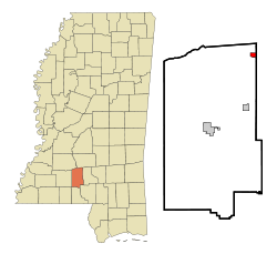
- New Hebron, Mississippi
-
New Hebron, Mississippi — Town — Location of New Hebron, Mississippi Coordinates: 31°43′59″N 89°58′55″W / 31.73306°N 89.98194°WCoordinates: 31°43′59″N 89°58′55″W / 31.73306°N 89.98194°W Country United States State Mississippi County Lawrence Area – Total 0.7 sq mi (1.7 km2) – Land 0.7 sq mi (1.7 km2) – Water 0.0 sq mi (0.0 km2) Elevation 371 ft (113 m) Population (2000) – Total 447 – Density 668.1/sq mi (257.9/km2) Time zone Central (CST) (UTC-6) – Summer (DST) CDT (UTC-5) ZIP code 39140 Area code(s) 601 FIPS code 28-51360 GNIS feature ID 0674644 New Hebron is a town in Lawrence County, Mississippi, United States. The population was 447 at the 2000 census.
Contents
Geography
New Hebron is located at 31°43′59″N 89°58′55″W / 31.73306°N 89.98194°W (31.732922, -89.981925)[1].
According to the United States Census Bureau, the town has a total area of 0.7 square miles (1.8 km2), all of it land.
Demographics
As of the census[2] of 2000, there were 447 people, 179 households, and 124 families residing in the town. The population density was 668.1 people per square mile (257.6/km²). There were 205 housing units at an average density of 306.4 per square mile (118.1/km²). The racial makeup of the town was 93.96% White, 5.59% African American, and 0.45% from two or more races. Hispanic or Latino of any race were 1.34% of the population.
There were 179 households out of which 33.0% had children under the age of 18 living with them, 60.9% were married couples living together, 7.3% had a female householder with no husband present, and 30.2% were non-families. 29.1% of all households were made up of individuals and 16.2% had someone living alone who was 65 years of age or older. The average household size was 2.50 and the average family size was 3.09.
In the town the population was spread out with 26.6% under the age of 18, 8.1% from 18 to 24, 26.4% from 25 to 44, 21.5% from 45 to 64, and 17.4% who were 65 years of age or older. The median age was 36 years. For every 100 females there were 82.4 males. For every 100 females age 18 and over, there were 87.4 males.
The median income for a household in the town was $32,500, and the median income for a family was $37,679. Males had a median income of $31,094 versus $24,167 for females. The per capita income for the town was $15,495. About 9.8% of families and 14.6% of the population were below the poverty line, including 11.1% of those under age 18 and 15.3% of those age 65 or over.
Education
The Town of New Hebron is served by the Lawrence County School District.
Religion
New Hebron has a rich church history with many beautiful churches located in our city.
New Hebron Pentecostal Church www.newhebronchurch.com 525 Jones Street New Hebron (601) 694-2569
Newhebron Baptist Church 311 Main Avenue New Hebron (601) 694-2243
New Hebron United Methodist 111 Main Avenue New Hebron (601) 892-4317
Notable natives
- Erick Dampier - NBA Player for the Dallas Mavericks; played at Lawrence County High School in Monticello, Mississippi and at Mississippi State University.
- Major Everett - Running back in the NFL for the Philadelphia Eagles, the Cleveland Browns and the Atlanta Falcons; played high school ball at New Hebron High School and at Mississippi College.
References
- ^ "US Gazetteer files: 2010, 2000, and 1990". United States Census Bureau. 2011-02-12. http://www.census.gov/geo/www/gazetteer/gazette.html. Retrieved 2011-04-23.
- ^ "American FactFinder". United States Census Bureau. http://factfinder.census.gov. Retrieved 2008-01-31.
Municipalities and communities of Lawrence County, Mississippi Towns Monticello | New Hebron | Silver Creek
Unincorporated
communitiesJayess | Nola | Oak Vale‡ | Oma | Sontag
Footnotes ‡This community also has portions in adjacent county or counties
Categories:- Towns in Mississippi
- Populated places in Lawrence County, Mississippi
Wikimedia Foundation. 2010.


