- North Loup, Nebraska
-
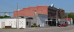
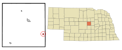
North Loup, Nebraska — Village — Downtown North Loup: north side of 1st Street Location of North Loup, Nebraska Coordinates: 41°29′41″N 98°46′17″W / 41.49472°N 98.77139°WCoordinates: 41°29′41″N 98°46′17″W / 41.49472°N 98.77139°W Country United States State Nebraska County Valley Area – Total 0.4 sq mi (1.1 km2) – Land 0.4 sq mi (1.1 km2) – Water 0.0 sq mi (0.0 km2) Elevation 1,962 ft (598 m) Population (2000) – Total 339 – Density 823.8/sq mi (318.1/km2) Time zone Central (CST) (UTC-6) – Summer (DST) CDT (UTC-5) ZIP code 68859 Area code(s) 308 FIPS code 31-34825[1] GNIS feature ID 0831708[2] North Loup is a village in Valley County, Nebraska, United States. The population was 339 at the 2000 census.
Contents
History
In 1871, a party of Seventh Day Baptists from Wisconsin explored Valley County for settlement sites. In May 1872, they established a community near what is now North Loup.[3] A post office and general store were established in 1873; in 1877, the town of North Loup was formally organized.[4] The name was taken from the North Loup River, in whose valley the village lies.[5]
In 1880, the Union Pacific Railroad completed a branch line from Grand Island to St. Paul, Nebraska, shortening the distance from the Valley County settlements to rail transport. In the following year, North Loup and Ord voted for $9,000 worth of bonds to help subsidize the railroad's extension through the two towns. The rail connection from St. Paul to North Loup was completed in 1882.[6]
The arrival of the railroad prompted a boom in North Loup, which lasted for some four years. In the course of a single year, the village's population doubled, to two hundred residents. The boom ended in 1886, when the railway line was finally completed to the county seat of Ord.[4][7]
From about 1877 to 1890, the Loup valley enjoyed a series of wet years that attracted a wave of settlers, who homesteaded even marginal agricultural land. In 1890, this ended with a series of drought years, lasting until about 1896. During this time, the valley's farmers experimented with alternative crops, among them winter wheat and alfalfa.[8] In the North Loup valley, one such crop was popcorn. The experiment was successful; in 1901, North Loup celebrated its first "Popcorn Days" celebration,[4] which continues to be held every August.[9]
The village grew rapidly from about 1900 to 1920. By 1915, there were over 600 residents. Growth continued, albeit very slowly, in the 1920s; the maximum population of 643 was reached in 1930. After World War II, the population declined; in 1959, the village was no longer able to support its own school district, which was merged with that of Scotia.[4]
2010 flood
On June 12, 2010, the privately owned Bredthauer Dam, located 4.5 miles (7.2 km) upstream from North Loup on Mira Creek, broke due to heavy rain, flooding rural Valley County.[10][11] Major flooding occurred in North Loup, with water "eight inches deep and running down Main Street."[12] The village was evacuated for the duration of the flood.[13]
Geography
North Loup is located at 41°29′41″N 98°46′17″W / 41.494856°N 98.771253°W (41.494856, -98.771253).[14] According to the United States Census Bureau, the village has a total area of 0.4 square miles (1.0 km2), all of it land.
Demographics
As of the census[1] of 2000, there were 339 people, 159 households, and 83 families residing in the village. The population density was 823.8 people per square mile (319.2/km2). There were 192 housing units at an average density of 466.6 per square mile (180.8/km2). The racial makeup of the village was 97.35% White, 1.77% from other races, and 0.88% from two or more races. Hispanic or Latino of any race were 2.36% of the population.
There were 159 households out of which 22.0% had children under the age of 18 living with them, 49.7% were married couples living together, 1.9% had a female householder with no husband present, and 47.2% were non-families. 42.8% of all households were made up of individuals and 26.4% had someone living alone who was 65 years of age or older. The average household size was 2.13 and the average family size was 3.06.
In the village the population was spread out with 24.8% under the age of 18, 2.9% from 18 to 24, 20.1% from 25 to 44, 20.6% from 45 to 64, and 31.6% who were 65 years of age or older. The median age was 46 years. For every 100 females there were 97.1 males. For every 100 females age 18 and over, there were 99.2 males.
The median income for a household in the village was $20,288, and the median income for a family was $25,750. Males had a median income of $21,750 versus $15,000 for females. The per capita income for the village was $12,672. About 22.1% of families and 24.1% of the population were below the poverty line, including 33.3% of those under age 18 and 21.3% of those age 65 or over.
References
- ^ a b "American FactFinder". United States Census Bureau. http://factfinder.census.gov. Retrieved 2008-01-31.
- ^ "US Board on Geographic Names". United States Geological Survey. 2007-10-25. http://geonames.usgs.gov. Retrieved 2008-01-31.
- ^ "North Loup" in "Valley County" chapter of Andreas' History of the State of Nebrasa. Retrieved 2011-06-04.
- ^ a b c d Fimple, Kathleen. "Historic Overview" in John Kay et al., "Nebraska Historic Buildings Survey: Reconnaissance Survey Final Report of Valley County, Nebraska". Nebraska State Historical Society. Retrieved 2011-06-03.
- ^ Fitzpatrick, Lilian Linder (1925). "Nebraska Place-Names". University of Nebraska Department of English. Retrieved 2010-09-02.
- ^ Foght, A. W. (1906). Chapter 17, "Changes Down Through the Years". The Trail of the Loup. Retrieved 2011-06-03.
- ^ Foght, A. W. (1906). Chapter 11, "Village Organization". The Trail of the Loup. Retrieved 2011-06-03.
- ^ Foght, A. W. (1906). Chapter 19, "The Critical Period in Loup Valley History". The Trail of the Loup. Retrieved 2011-06-03.
- ^ "North Loup Popcorn Days". Valley County Visitors Bureau. Retrieved 2011-06-03.
- ^ "Floodwaters overwhelm whole counties", Kearney Hub. 2010-06-14. Retrieved 2010-06-19.
- ^ Pore, R. "Heavy rains cause Ericson Dam to fail", Grand Island Independent. 2010-06-14. Retrieved 2010-06-19.
- ^ Geake, S. "North Loup Fights Flooding", 1011Now.com. 2010-06-14. Retrieved 2010-06-19.
- ^ Schweitzer, Amy. "North Loup flooded, evacuated". Grand Island Independent. 2010-06-12. Retrieved 2010-06-19.
- ^ "US Gazetteer files: 2010, 2000, and 1990". United States Census Bureau. 2011-02-12. http://www.census.gov/geo/www/gazetteer/gazette.html. Retrieved 2011-04-23.
External links
Municipalities and communities of Valley County, Nebraska City Villages Townships Arcadia | Davis Creek | Elyria | Enterprise | Eureka | Geranium | Independent | Liberty | Michigan | Noble | North Loup | Ord | Springdale | Vinton | Yale
Categories:- Populated places in Valley County, Nebraska
- Villages in Nebraska
Wikimedia Foundation. 2010.


