- Niuafo'ou
-
Niuafoʻou (volcano) 
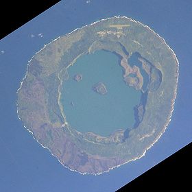
Niuafo'ou from the International Space Station, 2005-03-19Elevation 260 m (853 ft) Location Location Tonga, Oceania Coordinates 15°36′S 175°38′W / 15.60°S 175.63°W Geology Type Shield volcano Last eruption 1985 Niuafoʻou (meaning: many new coconuts) is the most northerly island in the kingdom of Tonga. It is a volcanic rim island of 15 km² and with a population of 650 in 2006.
Contents
Geography
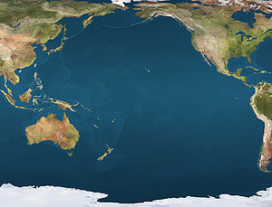
The island is located in the southern Pacific Ocean between Fiji and Samoa, 574 km north of Tongatapu island group and 337 kilometers northwest of Vavaʻu. It is still an active volcano.
Other names for the island are Good Hope island and Tin Can island. The latter name originated from the fact that, since the island has neither a natural harbor nor a wharf, mail was delivered and picked up by strong swimmers who would retrieve packages, "sealed up in a biscuit tin" and thrown overboard from passing ships. Established in the nineteenth century, Tin Can Mail was developed by a trader named Walter George Quensell, who festooned the mail with many colourful cachets that have become a collectors' item. The Tongan government took over this tradition with special Niuafoʻou stamps since 1983.
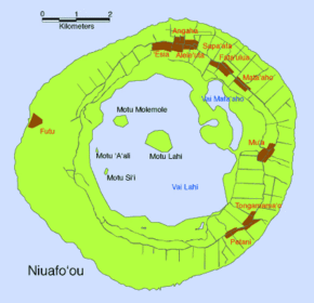
Niuafoʻou is a volcano located on an underwater ridge 190 kilometres (120 mi) west of the line of all the other volcanoes of Tonga. The island contains a steep-sided caldera; the rim is over 120 metres (390 ft) high, rising to a height of 250 metres (820 ft) at Mokotu. The coastline is rocky and steep with only a few stony black sand beaches. The only landing place on the island is the end of a lava flow at Futu, in the west. All the villages are in the north and east. Public places like the post office, telecommunications station and airport are in Angahā in the north, while a high school is located in Vai Lahi, is a crater lake 23 meters above sea level, 4 kilometers wide, and 84 meters deep. The lake contains three islands and a submerged island that appears when the water level drops. Vai Lahi is separated from the smaller Vai Siʻi (or Vai Mataʻaho) by a desolate landscape of sand hills. The island is covered by forest on the inner walls of the crater lake, and on the island's eastern and western slopes.
Niuafoʻou has been an active volcano for thousands of years. In 1853, the village of ʻAhau was destroyed, killing 25 people. Lava flows from eruptions in 1912 and 1929 destroyed the village of Futu, cut off the harbor, and killed all the vegetation on the western slopes of the island. Other eruptions occurred in 1935, 1936, 1943, and 1946. The 1946 eruption was a particularly violent one and in December 1946 Niuafoʻou's inhabitants were evacuated and resettled on the island of ʻEua. ʻEua and Niuafoʻou share many place names, (see list of cities in Tonga) showing where the resettlers went to. The first groups of inhabitants were allowed to return to the island in 1958.
History
According to the myths, Niuafoʻou originally had a mountain, rather than a lake in the middle. But the mountain was stolen one night and became Tafahi.
Niuafoʻou was put on the European maps by Willem Schouten and Jacob Le Maire during their famous circumnavigation of the globe in 1616. After their not so successful encounter with the islanders of Niuatoputapu, they approached this island with some more hope to find refreshments, so it was called Goede Hoop island. They found black cliffs, green on top, plenty of coconut trees, some houses along the seaside and a whole village near a landing place. But the ship the Eendracht (Unity) could not anchor and they had to limit themselves with some trade with the Indians who came along in their swift canoes. That went on fine for a short while. But when the islanders tried to get away with the small sounding boat, the Dutch had to use fire force again. After this they proceeded with their trip to the west, but veering towards the north and so happened to reach Futuna and Alofi.
Between 1946 and 1947, the island was completely evacuated by the Tongan government following a volcanic eruption. In 1957 about half of the population returned to Niuafo'ou, and the rest remained in 'Eua.[1]
In January 2002, the island was devastated by Cyclone Waka which destroyed hundreds of homes and killed one person.
See also
- List of volcanoes in Tonga
- Niuafo'ou language
- France–Tonga Delimitation Convention
Notes
- ^ Rogers, G. (1981). "The evacuation of Niuafo’ou, an outlier in the kingdom of Tonga". Journal of Pacific History 16 (3): 149–163. doi:10.1080/00223348108572421.
References
- "Niuafo'ou". Global Volcanism Program, Smithsonian Institution. http://www.volcano.si.edu/world/volcano.cfm?vnum=0403-11=.
- Douglas, Norman and Ngaire. Niuafoʻou & Niuatoputapu:Tonga a Guide Retrieved July 29, 2005.
- Kerr, Robert (1824) Voyage round the world, in 1615-1617, by William Cornelison Schouten and Jacques le Maire, going round Cape Horn. Beware that the notes added by the editor are often incorrect.
- Stanley, D. South Pacific Handbook
- Ramsay, Charles Stuart, and Plumb, Charles P. (1939) Tin Can Island: A Story of Tonga and the Swimming Mail Man of the South Seas, London: Hurst & Blackett.
External links
Categories:- Shield volcanoes
- Active volcanoes
- Volcanic calderas
- Crater lakes
- Volcanoes of Tonga
- Islands of Tonga
Wikimedia Foundation. 2010.


