- Tongatapu
Infobox Islands
name = Tongatapu
image caption =
locator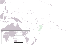
map_custom = no
native name =
native name link =
location =Pacific Ocean
coordinates= coord|21|12|41|S|175|09|11|W
archipelago =Tonga Islands
total islands =
major islands =
area = convert|257|km2|sqmi
highest mount =
elevation =
country = Tonga
country admin divisions title =
country admin divisions =
country largest city = Nukuokinaalofa
country largest city population = 22,400
population = 66,577
population as of = 1996
density = 259.05
ethnic groups =Tongatapu is the main island of
Tonga and the location of the capital Nukuokinaalofa. It is the most populous island, with approximately 66,577 residents, 68.3% of the population (in 1996). Tongatapu is the home island of the king (he has palaces in all the capitals of the major islands groups, but the late king's official residence (now of the queen-mother only) is theRoyal Palace, Tonga ). There are also numerous Tongan historical sites on the island. The capital, Nukuokinaalofa, has seen a more rapid economic development than the other islands and is thus a commercial hub, attracting many immigrants from outer islands.Before the reform of the
Tongan language spelling in 1943, the name was written was Tongatabu. The Tongan "p" is pronounced somewhat softly towards the "b", an effect that up to the 19th century was probably more pronounced than nowadays. At the beginning of the 20th century, many words originally written with a 'b' were already spelled with a 'p'. But such a well established name as Tongatapu was the last to follow. TheIATA abbreviation of Fuaokinaamotu International Airport is still TBU.European discovery
Tongatapu was discovered by Europeans on January 20, 1643 by
Abel Janszoon Tasman commanding two ships theHeemskerck and theZeehaen commissioned by theDutch East India Company ofBatavia (Jakarta). The expedition's goals were to chart the unknown southern and eastern seas and to find a possible passage through theSouth Pacific andIndian Ocean providing a faster route toChile . The expedition set sail from Batavia on August 14, 1642. Tasman named the island “t’ Eijlandt Amsterdam" (Amsterdam Island), because of its abundance of supplies [http://www.findingnz.co.nz/ap/gap2_europ_dis_of_tonga.htm] . This name is no longer used except by historians.Sites on Tongatapu
* Nukuokinaalofa - Capital of Tonga
* Muokinaa - Second largest city in Tongatapu
* Langi - Tombs of Tongan kings
* Mapu okinaa Vaea - Blowholes in the coral reef on the southern side
* Hūfangalupe - Natural landbridge on the south eastern side of Tongatapu
* Pangaimotu - Small resort island close to Nukuokinaalofa
* Landing site ofCaptain Cook
*Flying Fox Preserve - Located inKolovai in the western district
* Haokinaamonga okinaa Maui - Trilithon
*Nukuleka - possibly the site of first human settlement in TongaSee also List of islands & villages in Tonga
External links
* [http://www.tongatapu.net.to/tonga/news/facts.htm Tonga Quick Facts]
* [http://www.pausenberger.com/tonga.html photographs from Tongatapu, Tonga]
* [http://www.mapsouthpacific.com/tonga/tongatapu-map.html Map of Tongatapu]
* [http://www.findingnz.co.nz/ap/gap2_europ_dis_of_tonga.htm The European discovery of the Tonga Islands] by Brian Hooker
Wikimedia Foundation. 2010.