- New Richland, Minnesota
-
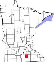
New Richland, Minnesota — City — Motto: "History is Ours, Future is Yours." Location of New Richland, Minnesota Detailed map of New Richland, Minnesota Coordinates: 43°53′40″N 93°29′40″W / 43.89444°N 93.49444°W Country  United States
State  Minnesota
County Waseca Government - Type Mayor - Council - Mayor Thomas McShane Area - Total 0.6 sq mi (1.5 km2) - Land 0.6 sq mi (1.5 km2) - Water 0.0 sq mi (0.0 km2) Elevation 1,181 ft (360 m) Population (2010)[1] - Total 1,203 - Density 2,002.8/sq mi (773.3/km2) Time zone Central (CST) (UTC-6) - Summer (DST) CDT (UTC-5) ZIP code 56072 Area code(s) 507 FIPS code 27-45862[2] GNIS feature ID 0648518[3] Website City website New Richland is a city in Waseca County, Minnesota, United States. The population was 1,203 at the 2010 census.[1] Located in rural south-central Minnesota, New Richland is a small town with a strong agricultural base.
Contents
Geography
According to the United States Census Bureau, the city has a total area of 0.6 square miles (1.6 km2), all of it land. Minnesota Highways 13 and 30 are two of the main routes in the city.
Demographics
Historical populations Census Pop. %± 1880 304 — 1890 423 39.1% 1900 750 77.3% 1910 685 −8.7% 1920 754 10.1% 1930 777 3.1% 1940 863 11.1% 1950 908 5.2% 1960 1,046 15.2% 1970 1,113 6.4% 1980 1,263 13.5% 1990 1,237 −2.1% 2000 1,197 −3.2% 2010 1,203 0.5% U.S. Decennial Census As of the census[2] of 2000, there were 1,197 people, 483 households, and 308 families residing in the city. The population density was 2,002.8 people per square mile (770.3/km²). There were 503 housing units at an average density of 841.6 per square mile (323.7/km²). The racial makeup of the city was 99.08% White, 0.08% Asian, 0.33% from other races, and 0.50% from two or more races. Hispanic or Latino of any race were 1.17% of the population.
There were 483 households out of which 28.8% had children under the age of 18 living with them, 50.9% were married couples living together, 9.1% had a female householder with no husband present, and 36.2% were non-families. 33.1% of all households were made up of individuals and 20.5% had someone living alone who was 65 years of age or older. The average household size was 2.34 and the average family size was 3.01.
In the city the population was spread out with 24.6% under the age of 18, 5.8% from 18 to 24, 25.0% from 25 to 44, 18.8% from 45 to 64, and 25.7% who were 65 years of age or older. The median age was 42 years. For every 100 females there were 86.2 males. For every 100 females age 18 and over, there were 79.0 males.
The median income for a household in the city was $36,406, and the median income for a family was $46,339. Males had a median income of $31,081 versus $22,500 for females. The per capita income for the city was $18,106. About 2.3% of families and 4.7% of the population were below the poverty line, including 5.2% of those under age 18 and 6.4% of those age 65 or over.
Education
Town life centers around its school, New Richland-Hartland-Ellendale-Geneva High School (NRHEG) and its various extra curricular activities. In 1976 and 1978 the then, New Richland-Hartland Cardinal football team won the State Championship and in 1999 the NRHEG Wrestling Team took 2nd in the state team tournament. In 2003, 2004, and 2005 wrestling team traveled to the state tournament in St. Paul in which they earned participation rights, 4th place, and consolation champs respectively. There have also been many high state awards earned in individual activities including speech, track & field and wrestling.
Notable residents
Gerald Gustafson, Air Force Cross awardee.
References
- ^ a b "2010 Census Redistricting Data (Public Law 94-171) Summary File". American FactFinder. United States Census Bureau. http://factfinder2.census.gov/faces/tableservices/jsf/pages/productview.xhtml?pid=DEC_10_PL_GCTPL2.ST13&prodType=table. Retrieved 27 April 2011.
- ^ a b "American FactFinder". United States Census Bureau. http://factfinder.census.gov. Retrieved 2008-01-31.
- ^ "US Board on Geographic Names". United States Geological Survey. 2007-10-25. http://geonames.usgs.gov. Retrieved 2008-01-31.
External links
- City website
- New Richland Star
- NRHEG Schools
- Seven Towns Where Land Is Free; CNBC.com; November 17, 2010
Municipalities and communities of Waseca County, Minnesota County seat: Waseca Cities Elysian‡ | Janesville | New Richland | Waldorf | Waseca
Townships Alton | Blooming Grove | Byron | Freedom | Iosco | Janesville | New Richland | Otisco | St. Mary | Vivian | Wilton | Woodville
Footnotes ‡This populated place also has portions in an adjacent county or counties
Coordinates: 43°53′38″N 93°29′38″W / 43.89389°N 93.49389°W
Categories:- Cities in Minnesota
- Populated places in Waseca County, Minnesota
Wikimedia Foundation. 2010.


