- Monk Fryston
-
Coordinates: 53°45′34″N 1°14′08″W / 53.759418°N 1.235496°W
Monk Fryston 
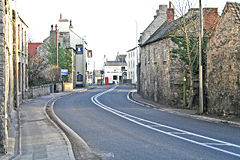
The main street in Monk Fryston
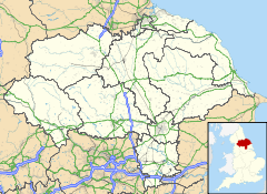
 Monk Fryston shown within North Yorkshire
Population 1,548 (2001) OS grid reference SE505295 District Selby Shire county North Yorkshire Region Yorkshire and the Humber Country England Sovereign state United Kingdom Post town LEEDS Postcode district LS25 Police North Yorkshire Fire North Yorkshire Ambulance Yorkshire EU Parliament Yorkshire and the Humber List of places: UK • England • Yorkshire Monk Fryston is a small village and civil parish in the Selby district of North Yorkshire, England. The name of the village originates from Monk's Free Stone[1] as all of the stone used to build Selby Abbey was obtained from a quarry in the centre of the village across the road from the old school building. The quarry was filled in for a housing development located next to the new school building, built on the old school field in 1998/9. The old school building has since been converted to housing.
The village is very closely linked to Hillam, although both villages maintain separate parish councils.
According to the 2001 UK census the population of Monk Fryston parish was 858.[2]
Monk Fryston is situated just over 6 miles west of the town of Selby. It lies 2 miles east of the A1(M) motorway junction 42, (A1 road), and 4 miles north of the M62 motorway, junction 33, at Ferrybridge. The A63 road, Leeds to Selby, runs through the village.
Primary education needs are served by Monk Fryston Church of England Primary school.
The Parish Church is St. Wilfrid's Monk Fryston (Church of England).
The village has two public houses, The Crown and The Blue Bell, and also a hotel, the Monk Fryston Hall hotel, which dates back to the 16th century.
The York and North Midland Railway passes to the west of Monk Fryston. An old station platform still exists next to the railway just down from the south milford sidings. The spot is popular with train enthusiasts.[3]
References
- ^ How the name 'Monk Fryston' came about ...
- ^ "Neighbourhood Statistics - Area: Monk Fryston CP". Office for National Statistics. http://neighbourhood.statistics.gov.uk/dissemination/LeadTableView.do?a=3&b=798278&c=monk+Fryston&d=16&e=15&g=477156&i=1001x1003x1004&m=0&r=1&s=1195422792664&enc=1&dsFamilyId=779. Retrieved 2007-11-18.
- ^ TS389 Monk Fryston - Trainspots
External links
- Parish Council
- St. Wilfrid's Church
- Monk Fryston Church of England Primary School
- The Ancient Parish of Monk Fryston
- Hillam News local newspaper
This Selby location article is a stub. You can help Wikipedia by expanding it.

