- Cần Giờ district, Hồ Chí Minh City
-
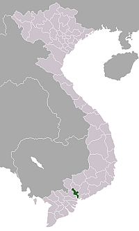
Cần Giờ is a coastal suburban district of Ho Chi Minh City, Dong Nam Bo, Vietnam.

This district is located 50 km from downtown Ho Chi Minh City. In 1997, this district had an area of 714 km², population of 55,173, comprising Kinh people (80%), Khmer Krom and Cham people. Can Gio district includes township Can Thanh and 6 communes (xã): Bình Khánh, An Thới Đông, Lý Nhơn, Tam Thôn Hiệp, Long Hòa and Thạnh An. Can Gio is home to Can Gio Mangrove Forest, a biosphere reserve listed by UNESCO. Can Gio shares borders with Nhon Trach, Vung Tau by the rivers and South China Sea.
As of 2006[update] the district had a population of 65,328.[1] The district covers an area of 704 km². The district capital lies at Phong Thanh.[1]
References
- ^ a b "Districts of Vietnam". Statoids. http://www.statoids.com/yvn.html. Retrieved March 20, 2009.
 Ho Chi Minh City
Urban districts: Binh Tan · Binh Thanh · District 1 · District 2 · District 3 · District 4 · District 5 · District 6 · District 7 · District 8 · District 9 · District 10 · District 11 · District 12 · Go Vap · Phu Nhuan · Tan Binh · Tan Phu · Thu Duc
Districts: Districts of Southeast Vietnam (Dong Nam Bo)Ho Chi Minh City Urban districts: Binh Tan · Binh Thanh · District 1 · District 2 · District 3 · District 4 · District 5 · District 6 · District 7 · District 8 · District 9 · District 10 · District 11 · District 12 · Go Vap · Phu Nhuan · Tan Binh · Tan Phu · Thu Duc
Districts: Binh Chanh · Can Gio · Cu Chi · Hoc Mon · Nha Be
Dong Nai province Bien Hoa · Cam My · Dinh Quan · Long Khanh · Long Thanh · Nhon Trach · Tan Phu · Thong Nhat · Trang Bom · Vinh Cuu · Xuan LocBinh Duong province Ba Ria–Vung Tau province Binh Phuoc province Tay Ninh province Binh Thuan province Categories:- Districts of Ho Chi Minh City
- Southeast Vietnam geography stubs
Wikimedia Foundation. 2010.