- New York State Route 20N
-
NYS Route 20N
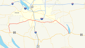
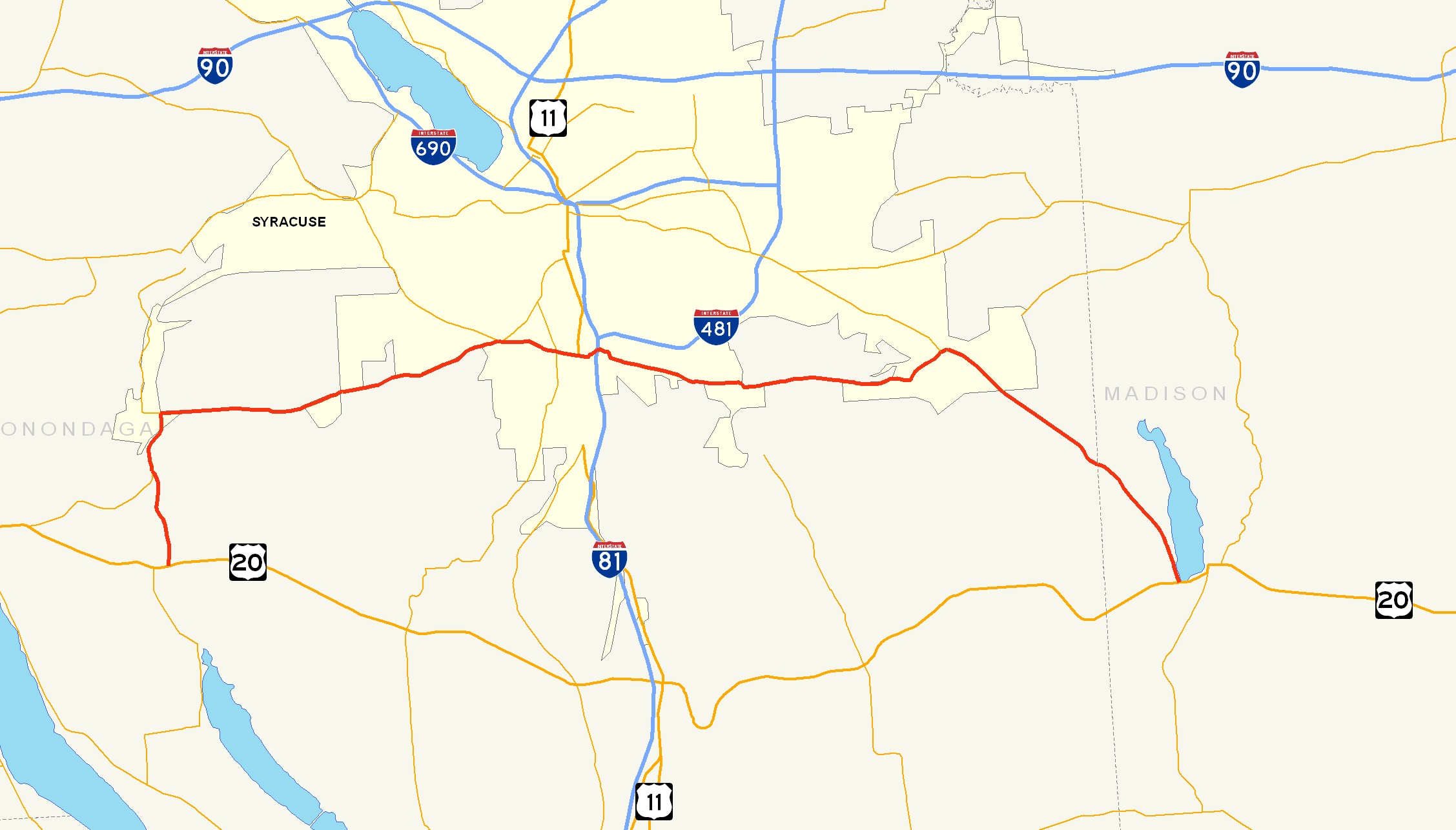
Map of the Syracuse area with NY 20N highlighted in redRoute information Auxiliary route of US 20 Maintained by New York Department of Public Works Length: 30.76 mi[5][6] (49.50 km) Existed: ca. 1938[1][2] – ca. 1962[3][4] Major junctions West end: 
 US 20 / NY 174 in Marcellus town
 NY 174 / NY 175 in Marcellus village
 US 11 in Syracuse


 NY 20SY / NY 92 / NY 173 in Manlius
East end: US 20 / NY 20SY / NY 92 in CazenoviaLocation Counties: Onondaga, Madison Highway system Numbered highways in New York
Interstate • U.S. • N.Y. (former) • Reference • County←  NY 20D
NY 20SY →New York State Route 20N (NY 20N) was a state highway in Central New York, United States. It was an alternate route of U.S. Route 20 (US 20) that stretched for 30.5 miles (49.1 km) between Marcellus and Cazenovia. The road began at its parent route, US 20, and NY 174 in Marcellus and ended at US 20, NY 20SY, and NY 92 in Cazenovia. All of NY 20N was concurrent with at least one other route, namely NY 174 in Marcellus, NY 175 from Marcellus to Onondaga Hill, NY 173 from Onondaga Hill to Manlius, and NY 92 and NY 20SY between Manlius and Cazenovia. NY 20N was assigned ca. 1938 and removed ca. 1962 along with NY 20SY.
Contents
Route description
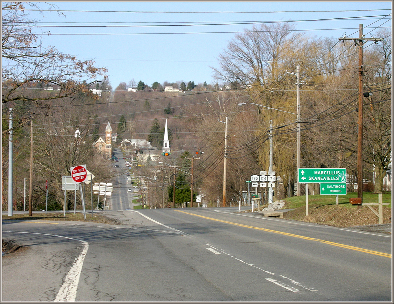
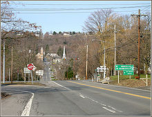 The modern intersection of NY 174 and NY 175 east of Marcellus, which NY 20N passed through
NY 20N began at an intersection with US 20 and NY 174 in the town of Marcellus. The route headed north, overlapping NY 174 through the town of Marcellus into the village of Marcellus. At the time, the two routes entered the village on South Street and followed it north to Main Street. NY 20N and NY 174 turned east, following Main for a half-block to North Street. Here, NY 20N and NY 174 split, with NY 174 heading to the west and NY 20N proceeding east along NY 175, which began at this junction at the time of NY 20N's removal.[3][7]
NY 20N and NY 175 continued east to Onondaga, where NY 173 joined the two routes and created a three-route overlap for 100 yards (91 m). At the east end of the overlap, NY 20N continued east along NY 173 into the southernmost section of Syracuse. Here, the two routes intersected NY 80 and US 11 and passed under Interstate 81 before exiting the city limits.[3][7]
Now in the town of De Witt, NY 20N and NY 173 met the northern terminus of NY 91 in the hamlet of Jamesville. The overlap between NY 20N and NY 173 ended 5 miles (8.0 km) to the east in the village of Manlius, where NY 92 and NY 20SY joined both routes just west of where NY 173 split from NY 20N and continued to the east.[3][7] Outside of Manlius, NY 20N, NY 20SY and NY 92 headed southeast for 7 miles (11 km) to Cazenovia, where all three routes ended at US 20 adjacent to Cazenovia Lake and west of the village.[3][8]
History
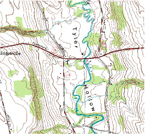
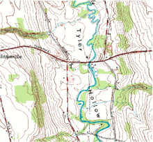 1976 topographical map of the US 20 / NY 174 concurrency and NY 20N's western terminus
The portion of NY 20N from the intersection of NY 174 and NY 175 in the village of Marcellus to the junction of NY 92 and NY 173 in Manlius was part of the Seneca Turnpike. The turnpike was created in the 1800s and at the time was the longest in the state.[9][10] NY 20N was assigned ca. 1938 as a northerly alternate route to US 20, which bypassed Syracuse to the south. The route extended from the town of Marcellus to the village of Cazenovia and overlapped NY 174, NY 175, NY 173, and NY 92 upon assignment.[1][2] All four of the routes that NY 20N originally overlapped were assigned as part of the 1930 renumbering of state highways in New York.[11]
A second, more northerly alternate route of US 20 in the Syracuse area was assigned in the early 1950s and designated as NY 20SY.[12][13] From Manlius to Cazenovia, NY 20SY overlapped NY 20N and NY 92.[14] Both NY 20N and NY 20SY were removed ca. 1962.[3][4]
Major intersections
County Location Mile[5][6] Destinations Notes Onondaga Town of Marcellus 0.00 US 20 / NY 174 southSouthern terminus of NY 20N / NY 174 overlap Village of Marcellus 3.67 NY 174 north / NY 175Northern terminus of NY 20N / NY 174 overlap; western terminus of NY 175; western terminus of NY 20N / NY 175 overlap Onondaga 12.01 NY 173 westHamlet of Onondaga Hill; western terminus of NY 20N / NY 173 overlap 12.07 NY 175 eastHamlet of Onondaga Hill; eastern terminus of NY 20N / NY 175 overlap Syracuse 13.33  NY 80
NY 8013.87 US 11DeWitt 17.87  NY 91
NY 91Hamlet of Jamesville; northern terminus of NY 91 Village of Manlius 22.83 NY 20SY west / NY 92 westWestern terminus of NY 20N / NY 20SY and NY 20N / NY 92 overlaps 22.99 NY 173 eastEastern terminus of NY 20N / NY 173 overlap Madison Village of Cazenovia 30.76 US 20 / NY 20SY / NY 92Eastern terminus of NY 20SY and NY 92; eastern terminus of NY 20N / NY 20SY and NY 20N / NY 92 overlaps 1.000 mi = 1.609 km; 1.000 km = 0.621 mi References
- ^ a b Standard Oil Company (1937). New York (Map). Cartography by General Drafting.
- ^ a b Thibodeau, William A. (1938). The ALA Green Book (1938–39 ed.). Automobile Legal Association.
- ^ a b c d e f Sunoco (1961). New York and Metropolitan New York (Map). Cartography by H.M. Gousha Company (1961-62 ed.).
- ^ a b Esso (1962). New York with Sight-Seeing Guide (Map). Cartography by General Drafting.
- ^ a b Yahoo! Inc. Yahoo! Maps – overview map of former NY 20N in Marcellus (Map). Cartography by NAVTEQ. http://maps.yahoo.com/#mvt=m&lat=42.970866&lon=-76.321578&zoom=15&q1=42.963147%2C-76.33565&q2=42.982466%2C-76.340049. Retrieved November 5, 2009.
- ^ a b "2008 Traffic Data Report for New York State" (PDF). New York State Department of Transportation. June 16, 2009. pp. 230, 258, 259. https://www.nysdot.gov/divisions/engineering/technical-services/hds-respository/NYSDOT_Traffic_Data_Report_2008.pdf. Retrieved November 5, 2009.
- ^ a b c Google, Inc. Google Maps – overview map of NY 20N from Marcellus to Manlius (Map). Cartography by Google, Inc. http://maps.google.com/maps?f=d&source=s_d&saddr=RT-174%2FSevier+Rd+%4042.931402,+-76.328410&daddr=South+St+to:Cazenovia+Rd%2FRT-92+%4042.999726,+-75.968746&geocode=FcoUjwIdJlJz-w%3BFaLajwId7SJz-w%3BFa4fkAIdFs94-w&hl=en&mra=ls&sll=42.981662,-76.33849&sspn=0.005581,0.013915&ie=UTF8&ll=42.97225,-76.149673&spn=0.178605,0.44529&z=12. Retrieved November 15, 2007.
- ^ Google, Inc. Google Maps – overview map of NY 20N from Manlius to Cazenovia (Map). Cartography by Google, Inc. http://maps.google.com/maps?hl=en&rlz=1T4ADBF_enUS232US232&q=from:+Cazenovia+Rd/RT-92+%4042.999726,+-75.968746+to:+Syracuse+Rd+%4042.925160,+-75.872470&um=1&ie=UTF-8&sa=N&tab=wl. Retrieved November 15, 2007.
- ^ Rivette, Barbara S. (2005). "Genesee Road". Encyclopedia of New York State. Syracuse University Press.
- ^ Baer, Christopher T. (2005). "Turnpikes". Encyclopedia of New York State. Syracuse University Press.
- ^ Standard Oil Company of New York (1930). Road Map of New York (Map). Cartography by General Drafting.
- ^ Socony-Vacuum Oil Company (1950). New York (Map). Cartography by Rand McNally and Company.
- ^ Sunoco (1952). New York (Map). Cartography by Rand McNally and Company.
- ^ Esso (1954). New York with Special Maps of Putnam–Rockland–Westchester Counties and Finger Lakes Region (Map). Cartography by General Drafting (1955–56 ed.).
External links
New York State Route 20SY New York State Route 5 • New York State Route 20N • New York State Route 92 • New York State Route 173 • New York State Route 321
New York State Route 20N  Categories:
- Former state highways in New York
- U.S. Route 20
- Transportation in Onondaga County, New York
- Transportation in Madison County, New York

Wikimedia Foundation. 2010.