- DeLand Municipal Airport
-
Coordinates: 29°04′01″N 081°17′02″W / 29.06694°N 81.28389°W
DeLand Municipal Airport
Sidney H. Taylor Field
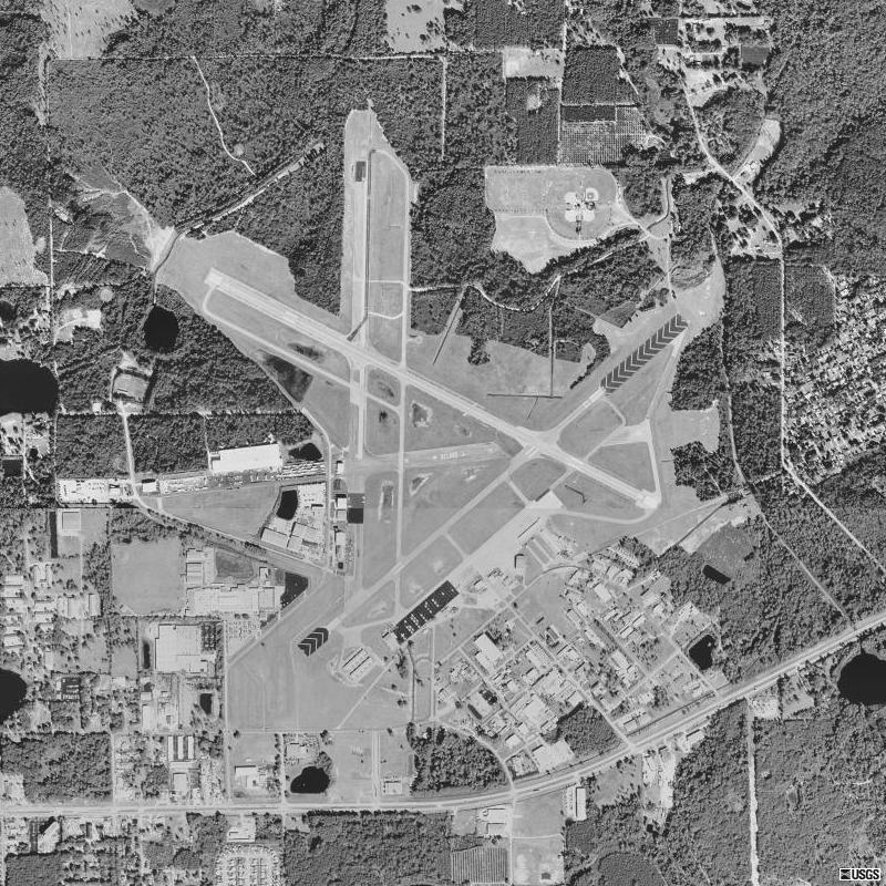
IATA: none – ICAO: KDED – FAA LID: DED Summary Airport type Public Owner City of DeLand Serves DeLand, Florida Elevation AMSL 79 ft / 24 m Website Runways Direction Length Surface ft m 12/30 6,000 1,829 Asphalt 5/23 4,300 1,311 Asphalt Statistics (2002) Aircraft operations 77,710 Based aircraft 162 Source: Federal Aviation Administration[1] DeLand Municipal Airport (ICAO: KDED, FAA LID: DED), also known as Sidney H. Taylor Field, is a city-owned public-use airport located three miles (5 km) northeast of the central business district of DeLand, a city in Volusia County, Florida, United States.[1]
Although most U.S. airports use the same three-letter location identifier for the FAA and IATA, DeLand Municipal Airport is assigned DED by the FAA but has no designation from the IATA (which assigned DED to Jolly Grant Airport in Dehradun, India).[2][3]
Contents
Facilities and aircraft
DeLand Municipal Airport covers an area of 1,289 acres (522 ha) which contains two asphalt paved runways: 12/30 measuring 6,000 x 100 ft (1,829 x 30 m) and 5/23: 4,300 x 75 ft (1,311 x 23 m).[1]
For the 12-month period ending May 7, 2002, the airport had 77,710 aircraft operations, an average of 212 per day: 99% general aviation, 1% air taxi and <1% military. There are 162 aircraft based at this airport: 70% single-engine, 23% multi-engine, 2% jet, 4% helicopter and 1% ultralight.[1]
History
Military use
Main article: DeLand Naval Air StationThe city first began developing the airport in the 1920s with the first asphalt runway laid around 1936. In 1942, the City of DeLand donated the facility to the U.S. Navy and it was renamed Naval Air Station DeLand on 17 November 1942.[4]
 Governor Claude Kirk visited DeLand Airport in March, 1967
Following extensive military construction, NAS DeLand's primary focus was advanced training for Navy flight crews in land-based PBO Ventura and PB4Y-2 Privateer patrol bombers, and carrier-based SBD Dauntless dive bombers. Several of the U.S. Navy's former and present day maritime patrol and reconnaissance (VP) squadrons operating the P-3 Orion trace their squadron lineage to being initially established at NAS DeLand during World War II.
In 1944, training in the carrier-based F6F Hellcat fighter was also added to NAS DeLand's mission.
As many as 331 officers and 1,140 enlisted men were stationed at NAS DeLand by early 1944. NAS DeLand also maintained an outlying field at Spruce Creek (OLF Spruce Creek) for use in carrier landing training, and boat facilities were maintained on Crescent Lake and at DeLeon Springs for use in rescuing downed pilots. Generally, pilots in trouble would rather crash land on water than land. Nine Mile Point on Lake George was also under NAS Deland's control and was used as a practice bombing site with a Navy PBY Catalina seaplane stationed nearby in the event of an aircraft mishap on the lake. This Lake George site is still used today as part of the Navy's Pinecastle Electronic Warfare and Bombing Range managed by NAS Jacksonville.[4]
NAS DeLand was decommissioned following the end of World War II, its control tower closed, and control of the airfield returned to the City of DeLand. Numerous former military buildings remain standing as part of the airport's industrial park and the Naval Air Station DeLand Museum.
Current use
Today, the airport serves as an uncontrolled general aviation reliever airport to commercial operations at Daytona Beach International Airport (DAB), Orlando Sanford International Airport (SFB) and Orlando International Airport (MCO). In 2007, an analysis was completed for the possible establishment of an FAA Level 1 air traffic control tower at DED under the FAA's Contract Tower Program.
References
- ^ a b c d FAA Airport Master Record for DED (Form 5010 PDF), effective 2007-10-25
- ^ Great Circle Mapper: KDED - DeLand, Florida (DeLand Municipal Airport)
- ^ Great Circle Mapper: DED / VIDN - Dehradun, India
- ^ a b "Florida in WWII - Historic Sites and Resources". Flheritage.com. http://www.flheritage.com/wwii/sites.cfm?PR_ID=76. Retrieved 2008-12-08.[dead link]
External links
- DeLand Municipal Airport at city website
- DeLand Municipal AirportPDF (953 KB) brochure from CFASPP (July 2006)
- Resources for this airport:
- AirNav airport information for DED
- FlightAware airport information and live flight tracker
- SkyVector aeronautical chart for DED
Categories:- Airports in Volusia County, Florida

Wikimedia Foundation. 2010.