- Office Bridge
-
Office Bridge
 Office Bridge and North Fork Middle Fork Willamette River
Location: Westfir, Oregon NRHP Reference#: 79003768 Added to NRHP: 1979  Interior of bridge shows strong construction intended for heavy vehicles
 Separate pedestrian walkway
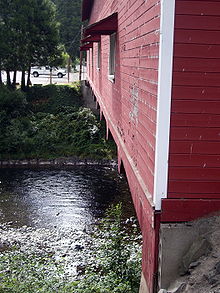
The Office Bridge (also called Westfir Covered Bridge[1]) is a covered bridge in Westfir, Lane County, Oregon, U.S. crossing the North Fork Middle Fork Willamette River at the south end of the Aufderheide National Scenic Byway[2] and edge of the Willamette National Forest. It is Oregon's longest covered bridge at 180 ft (55 m), and is one of only two in the state using triple Howe truss construction. It is the only covered bridge west of the Mississippi River which has a separate pedestrian walkway.[3][4][5]
The bridge is a replacement for a 1941 bridge which washed away.[6] It was built in 1944 by the Westfir Lumber Company[7] to carry logging trucks and lumber trucks to the company's lumber mill and mill pond. The company headquarters and offices were located across the river beside National Forest Development Road 19, in what is now a bed and breakfast. The bed and breakfast retains the company's walk-in safe.[8][9]
The company-owned town of Westfir, the mill, and the bridge were sold to an investment firm in 1977. The lumber mill burned to the ground in the early 1980s. In 1992 the bridge ownership changed to Lane County due to property tax foreclosure. Extensive structural work in 1993 stabilized the bridge.[10][11] In 2002, the roof was replaced.[8][12]
Formerly, the bridge was closed to public access. In about 2003, a small park was established on the north side of the bridge. The park also serves as a trailhead to North Fork Trail #3666, which follows the Wild and Scenic section of the North Fork river. The Wild and Scenic designation ends a few hundred feet upriver from the bridge. [13]
Each Christmas season, the town decorates the bridge with lights. A firetruck driven by Santa turns the lights on the first week after Thanksgiving.[14]
See also
References
- ^ "West Cascades Scenic Byway—Westfir Covered Bridge, Oregon". Byways.org. http://www.byways.org/explore/byways/13832/places/15373/. Retrieved 2007-11-11.
- ^ also known as the West Cascades National Scenic Byway
- ^ "Historic Bridge Provides Name for Westfir Fire". US Forest Service. September 3, 2002. http://www.fs.fed.us/r6/willamette/newsandevents/news/2002newsarchives/020903officebridgefire0530html.htm. Retrieved 2007-11-11.
- ^ "Office Bridge—Westfir, Oregon". Travel Oregon. http://www.traveloregon.com/Explore-Oregon/Willamette-Valley/Attractions/Covered-Bridges/Office-Bridge.aspx. Retrieved 2007-11-11.
- ^ Amber Fossen (November 14, 2006). "Office Bridge Commemorative Coin Set for Release". Lane County, Oregon Public Information Office. http://www.co.lane.or.us/News/News_2006/Release_28310.htm. Retrieved 2007-11-11.
- ^ "Office Bridge Limited Edition Print". Lane County, Oregon. http://ecomm.lanecounty.org/Store/Item.aspx?Item=19. Retrieved 2007-11-11.
- ^ later purchased by the Edward Hines Lumber Company
- ^ a b "North Fork of the Middle Fork Willamette River (Office) Covered Bridge". Oregon.com, Oregon Interactive Corporation. http://www.oregon.com/covered_bridges/bridges/office.cfm. Retrieved 2007-11-11.
- ^ "Area Attractions". Oakridge, Oregon chamber of commerce. Archived from the original on 2007-07-02. http://web.archive.org/web/20070702161232/http://www.oakridgechamber.com/attractions.asp. Retrieved 2007-11-11.
- ^ "Office Covered Bridge—Lane County, Oregon". OBEC Consulting Engineers. http://www.obec.com/bridges/office_cb.html. Retrieved 2007-11-11.[dead link]
- ^ "Projects: Bridges". 2G Construction. http://www.2gconstruction.com/projects/bridges.php. Retrieved 2007-11-11.
- ^ "Hikers and Bikers guide to the Center of Oregon's Recreation" (PDF). Oakridge Chamber of Commerce. pp. 15. http://www.oakridgechamber.com/documents/Bhiker%20Guide%20Final.pdf. Retrieved 2007-11-11.[dead link]
- ^ "Westfir, Oregon". OregonCities.us. http://www.oregoncities.us/westfir/index.htm. Retrieved 2007-11-11.
- ^ Susan G. Hauser (2003-03-23). "Over the River And Through the Bridge". New York Times. http://query.nytimes.com/gst/fullpage.html?res=980CE1D91231F930A15750C0A9659C8B63. Retrieved 2007-11-11.
External links
- Walk Through The Westfir Covered Bridge (Office Bridge) video walk across the bridge decorated for Christmas
- www.oregon.com: North Fork of the Middle Fork Willamette River (Office) Covered Bridge
- NationalBridges.com regarding Westfir Bridge
Coordinates: 43°45′30″N 122°29′45″W / 43.75847°N 122.49571°W
Categories:- Covered bridges in Lane County, Oregon
- Bridges on the National Register of Historic Places in Oregon
- Bridges completed in 1944
- National Register of Historic Places in Lane County, Oregon
- Road bridges in Oregon


Wikimedia Foundation. 2010.