- Bridge of Orchy railway station
-
Bridge of Orchy 
Drochaid Urchaidh 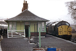
Location Place Bridge of Orchy Local authority Argyll and Bute Coordinates 56°30′58″N 4°45′47″W / 56.516°N 4.763°WCoordinates: 56°30′58″N 4°45′47″W / 56.516°N 4.763°W Operations Station code BRO Managed by First ScotRail Number of platforms 2 Live arrivals/departures and station information
from National Rail EnquiriesAnnual rail passenger usage 2004/05 * 4,941 2005/06 * 5,112 2006/07 * 5,108 2007/08 * 5,966 2008/09 * 6,240 History Original company West Highland Railway Pre-grouping North British Railway Post-grouping LNER 7 August 1894[1] Opened National Rail - UK railway stations A B C D E F G H I J K L M N O P Q R S T U V W X Y Z * Annual passenger usage based on sales of tickets in stated financial year(s) which end or originate at Bridge of Orchy from Office of Rail Regulation statistics. Please note: methodology may vary year on year. Bridge of Orchy railway station is a railway station in the village of Bridge of Orchy in the west of Scotland. This station is on the West Highland Line. Being an island platform, access is via a subway.
Contents
History
This station opened by the West Highland Railway on 7 August 1894.[1]
The station was laid out with a crossing loop around an island platform and sidings on the east side of the station.
On 1 February 1987, the crossing loop was altered to right-hand running. The original Down platform has thus become the Up platform, and vice versa. The change was made in order to simplify shunting at this station, by removing the need to hand-pump the train-operated loop points to access the sidings.
Preceding station  National Rail
Following station Upper Tyndrum First ScotRail
West Highland LineRannoch Upper Tyndrum First ScotRail
Highland Caledonian SleeperRannoch Historical railways Tyndrum North British Railway
Gorton Signalling
The signal box, which had 16 levers, was situated at the south end of the island platform. From the time of its opening in 1894, the West Highland Railway was worked throughout by the electric token system.
In 1967, the method of working between Crianlarich and Rannoch was changed to the Scottish Region Tokenless Block system. The Up loop at Bridge of Orchy was signalled for running in either direction and the signal box was able to 'switch out' when not required.
In August 1985, the method of working between Crianlarich and Rannoch reverted to the electric token block system. The semaphore signals were removed on 24 November 1985 in preparation for the introduction of Radio Electronic Token Block (RETB).
The RETB system was commissioned between Upper Tyndrum and Fort William Junction on 29 May 1988. This resulted in the closure of Bridge of Orchy signal box (amongst others). The RETB is controlled from a Signalling Centre at Banavie railway station.
The Train Protection & Warning System was installed in 2003.
Station building
The station building is now used as a bunkhouse for those walking the West Highland Way.
Locality
The Bridge of Orchy Hotel is opposite the end of the road down from the station.
References
Notes
Sources
- Butt, R. V. J. (1995). The Directory of Railway Stations: details every public and private passenger station, halt, platform and stopping place, past and present (1st ed.). Sparkford: Patrick Stephens Ltd. ISBN 1-8526-0508-1. OCLC 60251199.
- Jowett, Alan (March 1989). Jowett's Railway Atlas of Great Britain and Ireland: From Pre-Grouping to the Present Day (1st ed.). Sparkford: Patrick Stephens Ltd. ISBN 1-8526-0086-1. OCLC 22311137.
Categories:- Railway stations in Argyll and Bute
- Former North British Railway stations
- Railway stations opened in 1894
- Railway stations served by First ScotRail

Wikimedia Foundation. 2010.