- Upper Tyndrum railway station
Infobox UK station
name = Upper Tyndrum
other_name= Taigh an Droma Uarach
code = UTY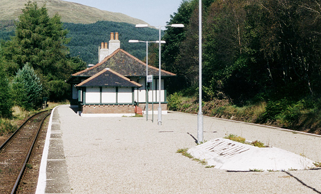
caption = Looking north on the formerWest Highland Railway to Fort William
manager =First ScotRail
locale =Tyndrum
borough = Stirling
lowusage0405 = 126
lowusage0506 = 128
lowusage0607 = 7529
platforms = 2
years =1894
events = Station opened as Tyndrum
years1 =1953
events1 = Station renamed as Tyndrum Upper
years2 =1988
events2 = Station renamed as Upper Tyndrum
years3 =
events3 =|Upper Tyndrum railway station is one of two
railway station s serving the small village ofTyndrum inScotland . It is located on the Fort William route of the highly scenicWest Highland Line . Services are operated byFirst ScotRail . In 2005/06 it was the least used station on the West Highland Line, probably because of its position at the top of a steep hill above the village, as opposed to Tyndrum Lower on the Oban branch.Gallery
History
Originally named "Tyndrum", this station opened concurrently with the West Highland Railway in 1894, doubling the number of railway stations in the village. In 1953,
British Rail added the suffix "Upper" to the station's name, in order to distinguish it from the station on the Callander and Oban Line which then became known as Tyndrum Lower.The station name was altered to Upper Tyndrum upon the introduction of RETB (see below), to reduce the risk of it being confused with Tyndrum Lower in radio communications.
= Signalling =The
signal box , which had 15 levers, was situated on theisland platform . From the time of its opening in 1894, the West Highland Railway was worked throughout by the electric token system.In 1967, the method of working between Crianlarich and Rannoch was changed to the
Scottish Region Tokenless Block system. The Down loop at Tyndrum Upper was signalled for running in either direction and the signal box was able to 'switch out' when not required.In August 1985, the method of working between Crianlarich and Rannoch reverted to the electric token block system. The semaphore signals were removed on
22 December 1985 in preparation for the introduction ofRadio Electronic Token Block (RETB).The RETB system was commissioned between Helensburgh Upper and Upper Tyndrum on
27 March 1988 . On29 May of the same year, the RETB spread north toFort William Junction , resulting in the closure of Upper Tyndrum signal box (amongst others). The RETB is controlled from a purpose-built Signalling Centre atBanavie railway station . Upper Tyndrum station is the boundary between the two signallinginterlocking s and the areas of control of the two signalmen.The
Train Protection & Warning System was installed in 2003.External links
*gbmapping|NN334303
###@@@KEYEND@@@###
Wikimedia Foundation. 2010.