- Spean Bridge railway station
-
Spean Bridge 
Drochaid an Aonachain 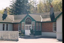
The former station building, now a restaurant Location Place Spean Bridge Local authority Highland Coordinates 56°53′24″N 4°55′19″W / 56.890°N 4.922°WCoordinates: 56°53′24″N 4°55′19″W / 56.890°N 4.922°W Operations Station code SBR Managed by First ScotRail Number of platforms 2 Live arrivals/departures and station information
from National Rail EnquiriesAnnual rail passenger usage 2004/05 * 5,911 2005/06 * 5,725 2006/07 * 6,361 2007/08 * 6,345 History 7 August 1894 Opened 22 July 1903 Services to Fort Augustus commenced 1 December 1933 Line to Fort Augustus closed National Rail - UK railway stations A B C D E F G H I J K L M N O P Q R S T U V W X Y Z * Annual passenger usage based on sales of tickets in stated financial year(s) which end or originate at Spean Bridge from Office of Rail Regulation statistics. Please note: methodology may vary year on year. Spean Bridge railway station is a railway station serving the village of Spean Bridge in the Highland region of Scotland. This station is on the West Highland Line.
History
The station was laid out with two platforms, one on either side of a crossing loop. There are sidings on the north side of the station.
On 18 January 1987, the crossing loop was altered to right-hand running. The original Down platform has thus become the Up platform, and vice versa. The change was made in order to simplify shunting at this station, by removing the need to hand-pump the train-operated loop points to access the sidings.
Between 1903 and 1933, there was a branch line from this station which offered service north up the Great Glen to Fort Augustus.
Signalling
From the time of its opening in 1894, the West Highland Railway was worked throughout by the electric token system.
Alterations in connection with the construction of the line to Fort Augustus saw the original Spean Bridge signal box replaced by two new boxes in 1901. Spean Bridge Junction box was subsidiary to Spean Bridge Station box. The Junction box closed on 20 September 1921.
The most recent signal box at Spean Bridge, which opened on 28 August 1949, was located on the Up platform (which is now the Down platform). It contained 30 levers.
Spean Bridge lost all its semaphore signals on 2 March 1986, in preparation for Radio Electronic Token Block (RETB) signalling. The RETB system was commissioned between Upper Tyndrum and Fort William Junction on 29 May 1988. This resulted in the closure of Spean Bridge signal box and others on that part of the line. The RETB is controlled from a Signalling Centre at Banavie railway station.
The Train Protection & Warning System was installed in 2003.
External links
- Train times and station information for Spean Bridge railway station from National Rail
Preceding station  National Rail
Following station Roy Bridge First ScotRail
West Highland LineFort William Tulloch
or
Roy Bridge
(on request)First ScotRail
Highland Caledonian SleeperFort William Historical railways Roy Bridge
Line and Station openWest Highland Railway Fort William
Line and Station openTerminus Invergarry and Fort Augustus Railway Gairlochy
Line and Station closedCategories:- Railway stations in Highland (council area)
- Former North British Railway stations
- Railway stations opened in 1894
- Railway stations served by First ScotRail

Wikimedia Foundation. 2010.