- Corrour railway station
-
Corrour 
Coire Odhar 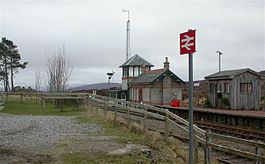
Corrour station Location Place Loch Ossian Local authority Highland Coordinates 56°45′36″N 4°41′27″W / 56.7601°N 4.6909°WCoordinates: 56°45′36″N 4°41′27″W / 56.7601°N 4.6909°W Operations Station code CRR Managed by First ScotRail Number of platforms 1 Live arrivals/departures and station information
from National Rail EnquiriesAnnual rail passenger usage 2005/06 * 9,885 2006/07 *  11,045
2007/08 * 13,2262008/09 *  12,724
2009/10 * 12,280History Original company West Highland Railway Pre-grouping North British Railway Post-grouping LNER 7 August 1894 Opened[1] National Rail - UK railway stations A B C D E F G H I J K L M N O P Q R S T U V W X Y Z * Annual passenger usage based on sales of tickets in stated financial year(s) which end or originate at Corrour from Office of Rail Regulation statistics. Please note: methodology may vary year on year. Corrour railway station is a railway station on the West Highland Line, Scotland. It is situated near Loch Ossian and Loch Treig, on the Corrour Estate. It is the highest mainline railway station in the United Kingdom.
Contents
Location
The railway station is one of the most remote stations in the United Kingdom, at an isolated location on Rannoch Moor. The station is not accessible by any public roads – the nearest road is 10 miles (16 km) away. The original Station House reopened in May 2010, providing a cafe and bed and breakfast accommodation run by the Scottish Youth Hostel Association. At 408 m (1,339 ft) above sea level the station provides a convenient starting point for hill-walkers and Munro-baggers. Loch Ossian Hostel, one of the most remote youth hostels in the UK, is about one mile from the railway station.
History
Sir John Stirling-Maxwell (10th Baronet of Pollok, KT) purchased Corrour Estate in 1891 and initially used it as a "playground" for gentlemen, primarily focusing on activities such as stalking and hunting.[2] To make it accessible for his guests, Sir Stirling-Maxwell gave access to the West Highland Railway Company to build across his land on condition that they build a railway station for him on his estate. This station opened to passengers on 7 August 1894.[1] It was originally built to serve the Corrour sporting estate, whose owners were investors in the railway. Guests visiting the estate for deer stalking and grouse shooting were taken from the station to the head of Loch Ossian by horse drawn carriage. A small steamer then transported them to shooting lodge at the far end of the loch.
The station was laid out with a passing loop around an island platform and a siding on the east side. Since November 1985, all passenger trains have used the original Down platform. The Up loop remains but it is no longer used by passenger trains. There had been a footbridge at Corrour station providing an exit to the east side, but it was moved to Rannoch railway station following the downgrading of the Up loop at Corrour. Passengers now cross the line by way of a footpath.
Services
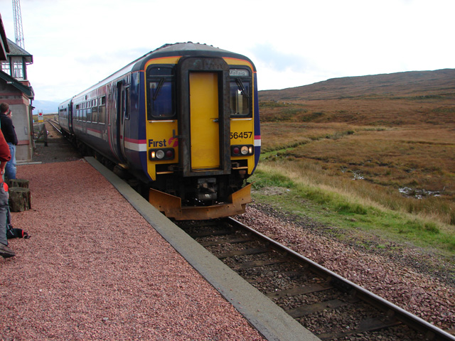
 A train to Mallaig
Corrour station is connected by regular services linking Glasgow Queen Street with Fort William and Mallaig. These local services run generally thrice daily in each direction, but less frequently on Sundays.
Despite its remote location – Corrour boasts a direct connection to London via the Caledonian Sleeper to and from London Euston (daily except Saturday nights in each direction), The journey from London to Corrour takes just under twelve hours.
All services serving Corrour are run by First ScotRail.
Preceding station  National Rail
Following station Rannoch First ScotRail
West Highland LineTulloch Rannoch First ScotRail
Highland Caledonian SleeperTulloch Historical railways Rannoch North British Railway
Tulloch Signalling
The signal box, which had 13 levers, was situated to the south of the island platform. From the time of its opening in 1894, the West Highland Railway was worked throughout by the electric token system. The semaphore signals were removed in November 1985 in preparation for the introduction of Radio Electronic Token Block (RETB). At the same time, the loop points came under the control of ground frames. The RETB system was commissioned between Upper Tyndrum and Fort William Junction on 29 May 1988. This resulted in the closure of Corrour signal box and others on that part of the route. The RETB is controlled from a Signalling Centre at Banavie railway station.
In popular culture
The station, and the nearby mountain Leum Uilleim, gained fame when they were featured in a scene from the film Trainspotting. It also appeared in the fourth episode of the 2010 BBC series Secret Britain. The station also featured in the Young Guns (band) video for the single "Weight Of The World". The station is the primary location in Jos Stelling's film De Wisselwachter.
References
Notes
- ^ a b Butt (1995)
- ^ About Corrour
Sources
- Butt, R. V. J. (1995). The Directory of Railway Stations: details every public and private passenger station, halt, platform and stopping place, past and present (1st ed.). Sparkford: Patrick Stephens Ltd. ISBN 1-8526-0508-1. OCLC 60251199.
- Jowett, Alan (March 1989). Jowett's Railway Atlas of Great Britain and Ireland: From Pre-Grouping to the Present Day (1st ed.). Sparkford: Patrick Stephens Ltd. ISBN 1-8526-0086-1. OCLC 22311137.
- Jowett, Alan (2000). Jowett's Nationalised Railway Atlas (1st ed.). Penryn, Cornwall: Atlantic Transport Publishers. ISBN 0-9068-9999-0. OCLC 228266687.
- Yonge, John (May 1987). Gerald Jacobs. ed. British Rail Track Diagams - Book 1: ScotRail (1st edition ed.). Exeter: Quail Map Company. ISBN 0-9006-0948-6.
- Yonge, John (February 1993). Gerald Jacobs. ed. Railway Track Diagams - Book 1: Scotland and the Isle of Man (2nd edition ed.). Exeter: Quail Map Company. ISBN 0-9006-0995-8.
- Yonge, John (April 1996). Gerald Jacobs. ed. Railway Track Diagams - Book 1: Scotland and the Isle of Man (3rd edition ed.). Exeter: Quail Map Company. ISBN 1-8983-1919-7.
- Yonge, John (2007). Gerald Jacobs. ed. Railway Track Diagams - Book 1: Scotland & Isle of Man (Quail Track Plans) (fifth edition ed.). Bradford on Avon: "Trackmaps (formerly Quail Map Co)". http://www.trackmaps.co.uk.. ISBN 978-0-9549866-3-6. OCLC 79435248.
- Scotland: the Movie Location Guide – Trainspotting, Rannoch Moor Information on the station as it appears in "Trainspotting".
- Corrour Further details on the station.
- Hidden Europe magazine – an article about Corrour from Hidden Europe magazine.
- Article on the station by Ian Futers, four pages including track plan, photos, and description in Railway Modeller magazine for April 2008.
Categories:- Railway stations in Highland (council area)
- Former North British Railway stations
- Railway stations opened in 1894
- Railway stations served by First ScotRail
- British railway stations without road access
- Bed and breakfasts

Wikimedia Foundation. 2010.