Arrochar and Tarbet railway station

Arrochar and Tarbet railway station

Infobox UK station
name = Arrochar and Tarbet
other_name = An Tairbeart
code = ART


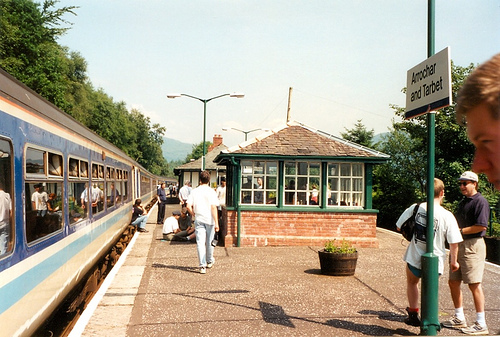
caption = View of platform, looking north
manager = First ScotRail
locale = Arrochar & Tarbet
borough = Argyll and Bute
latitude = 56.204
longitude = -4.723
platforms = 2
lowusage0405 = 7,998
lowusage0506 = 9,171
lowusage0607 = 10,067
original = West Highland Railway
pregroup = North British Railway
postgroup = LNER
years = 7 August 1894
events = OpenedButt (1995), page 19]
years1 =
events1 =|

Arrochar and Tarbet railway station is a railway station on the West Highland Line in Scotland. It stands between the villages of Arrochar and Tarbet.

History

Opened to passengers on 7 August 1894 by the West Highland Railway, then run by the North British Railway, it became part of the London and North Eastern Railway during the Grouping of 1923. The station then passed on to the Scottish Region of British Railways on nationalisation in 1948.

When Sectorisation was introduced in the 1980s, the station was served by ScotRail until the Privatisation of British Railways. The station was laid out with a crossing loop and an island platform. The sidings on the east side of the station are presently used for loading timber.

When the platform was extended southwards, the redundant signal box was relocated slightly further north for use as a waiting room. In 2000, a replica of the signal box was built in the centre of the island platform, after the station building had to be demolished due to subsidence.


= Signalling =

From the time of its opening in 1894, the West Highland Railway was worked throughout by the electric token system. Arrochar & Tarbet signal box, which had 17 levers, was situated on the island platform.

The semaphore signals were removed on 19 January 1986 in preparation for the introduction of Radio Electronic Token Block (RETB). The RETB, which is controlled from a Signalling Centre at Banavie railway station, was commissioned between Helensburgh Upper and Upper Tyndrum on 27 March 1988.

After the signal box closed, the lever frame was removed for re-use on the Leadhills and Wanlockhead Railway.

The Train Protection & Warning System was installed in 2003.

Services

rail line
next = Ardlui
previous = Garelochhead
route = First ScotRail
West Highland Line
col = FF80c0
rail line
next = Crianlarich
or
Ardlui
(request stop)
previous = Garelochhead
route = First ScotRail
Highland Caledonian Sleeper
col = ff80c0
rail line
next = Ardlui
Line and Station open
previous = Glen Douglas
Line open; Station closed
route = West Highland Railway

North British Railway
col = NBR colour

###@@@KEYEND@@@###

References

Notes

Sources

*
*
*
* [http://www.railscot.co.uk/West_Highland_Railway/frame.htm RAILSCOT on the West Highland Railway]


Wikimedia Foundation. 2010.

Игры ⚽ Нужно сделать НИР?

Look at other dictionaries:

  • Arrochar, Argyll and Bute — Arrochar ( An t Arar or An Tairbeart Iar in Gaelic) is a village located near the head of Loch Long in Argyll and Bute, Scotland.It is overlooked by a group of mountains called the Arrochar Alps, and in particular by the distinctive rocky summit… …   Wikipedia

  • Tarbet, Argyll and Bute — Tarbet is a small village in Argyll and Bute, Scotland.Traditionally on the northern fringes of the historic County of Dunbarton, it is on the banks of Loch Lomond, and has a pier. It stands on an isthmus where Loch Long and Loch Lomond come… …   Wikipedia

  • Ardlui railway station — Infobox UK station name = Ardlui other name= Àrd Laoigh code = AUI caption = Ardlui station is unusually busy as passengers on a Mallaig and Oban Glasgow train stretch their legs whilst waiting for a late running northbound train to cross manager …   Wikipedia

  • List of places in Argyll and Bute — This List of places in Argyll and Bute is a list of links for any town, village, hamlet, castle, golf course, historic house, lighthouse, nature reserve, reservoir, river, canal, and other place of interest in Argyll and Bute, Scotland,… …   Wikipedia

  • Garelochhead railway station — Infobox UK station name = Garelochhead other name= Ceann a Gheàrrloch code = GCH manager = First ScotRail locale = Garelochhead borough = Argyll and Bute platforms = 2 pte = SPT lowusage0203 = 3,868 lowusage0405 = 4,824 lowusage0506 = 5,940… …   Wikipedia

  • Loch Lomond — Infobox lake lake name = Loch Lomond image lake = View of loch lomond.jpg caption lake = image bathymetry = caption bathymetry = coords = coord|56|05|N|4|34|W|display=title|region:GB scale:300000 source:GNS enwiki type = Loch, Ribbon lake inflow …   Wikipedia

  • ART — is a three letter acronym that can mean:Medicine* Antiretroviral therapy. It is used in the treatment of HIV infection. * assisted reproductive technology * Androgen Replacement TherapyART Acronyms and Definitions* Available Revenue Time *… …   Wikipedia

  • West Highland Line — Glasgow Queen Street–Oban/Mallaig Streckenlänge: 163/264 km Spurweite: 1435 mm (Normalspur) Zweigleisigkeit: nein Legende …   Deutsch Wikipedia

  • Ardlui — ( Àrd Laoigh in Gaelic) is a hamlet in Argyll and Bute, Scotland. It is located at the head of Loch Lomond. It is on the A82 road between Crianlarich and Glasgow and Ardlui railway station is on the West Highland Line between Glasgow Queen Street …   Wikipedia

  • West Loch Lomond Cycle Path — cite web|url=http://www.lochlomond trossachs.org/park/default.asp?p=23|title=West Loch Lomond Cycle Path Update August 2005|work=Loch Lomond amp; The Trossachs National Park] The path is about 28 kilometers (16.5 miles) long, and runs along the… …   Wikipedia

Share the article and excerpts

Direct link
Do a right-click on the link above
and select “Copy Link”