- Oak Grove, Minnesota
-
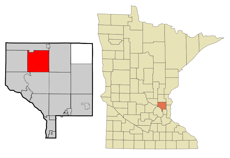
Oak Grove, Minnesota — City — Location of Oak Grove, Minnesota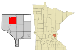
Coordinates: 45°20′17″N 93°20′0″W / 45.33806°N 93.333333°W Country United States State Minnesota County Anoka Area – Total 35.0 sq mi (90.7 km2) – Land 33.7 sq mi (87.3 km2) – Water 1.3 sq mi (3.4 km2) Elevation 896 ft (273 m) Population (2010)[1] – Total 8,031 – Density 204.9/sq mi (79.1/km2) Time zone Central (CST) (UTC-6) – Summer (DST) CDT (UTC-5) ZIP codes 55011, 55303 Area code(s) 763 FIPS code 27-47690[2] GNIS feature ID 1669536[3] Website www.ci.oak-grove.mn.us Oak Grove is a city in Anoka County, Minnesota, United States. It is north of Minneapolis. The population was 8,031 at the 2010 census.[1] The city was formerly Oak Grove Township before it was incorporated on December 20, 1993.[4]
Contents
History
Oak Grove became an organized township in 1857, and was so named because of the large groves of oak trees in the area. The village of Oak Grove was founded in 1854 and operated a post office from 1857 to 1901. The township incorporated as a city in 1993.[5]
Geography
According to the United States Census Bureau, the city has a total area of 35.0 square miles (91 km2), of which, 33.7 square miles (87 km2) of it is land and 1.3 square miles (3.4 km2) of it (3.77%) is water. County Roads 9 and 22 are two of the main routes in the community.
Adjacent cities
- St. Francis (north)
- East Bethel (east)
- Nowthen (west)
- Andover (south)
- Ramsey (southwest)
Demographics
As of the census[2] of 2000, there were 6,903 people, 2,200 households, and 1,883 families residing in the city. The population density was 204.9 people per square mile (79.1/km²). There were 2,232 housing units at an average density of 66.2 per square mile (25.6/km²). The racial makeup of the city was 97.20% White, 0.51% African American, 0.68% Native American, 0.48% Asian, 0.22% from other races, and 0.91% from two or more races. Hispanic or Latino of any race were 0.59% of the population.
There were 2,200 households out of which 45.6% had children under the age of 18 living with them, 76.3% were married couples living together, 5.0% had a female householder with no husband present, and 14.4% were non-families. 10.6% of all households were made up of individuals and 1.6% had someone living alone who was 65 years of age or older. The average household size was 3.11 and the average family size was 3.33.
In the city the population was spread out with 32.0% under the age of 18, 6.8% from 18 to 24, 33.8% from 25 to 44, 23.9% from 45 to 64, and 3.5% who were 65 years of age or older. The median age was 34 years. For every 100 females there were 114.4 males. For every 100 females age 18 and over, there were 112.8 males.
The median income for a household in the city was $70,169, and the median income for a family was $73,728. Males had a median income of $44,855 versus $29,009 for females. The per capita income for the city was $23,693. About 1.0% of families and 1.5% of the population were below the poverty line, including 0.9% of those under age 18 and 3.6% of those age 65 or over.
Also the home town of Sean Sherk
References
- ^ a b "2010 Census Redistricting Data (Public Law 94-171) Summary File". American FactFinder. U.S. Census Bureau, 2010 Census. http://factfinder2.census.gov/faces/tableservices/jsf/pages/productview.xhtml?pid=DEC_10_PL_GCTPL2.ST13&prodType=table. Retrieved 23 April 2011.
- ^ a b "American FactFinder". United States Census Bureau. http://factfinder.census.gov. Retrieved 2008-01-31.
- ^ "US Board on Geographic Names". United States Geological Survey. 2007-10-25. http://geonames.usgs.gov. Retrieved 2008-01-31.
- ^ "Geographic Change Notes: Minnesota". 1990s boundary changes. U.S. Census Bureau. http://www.census.gov/popest/archives/1990s/boundary_changes/27.html. Retrieved 2009-07-06.
- ^ Upham, Warren (2001). Minnesota Place Names (3rd ed.). St. Paul, Minnesota: Minnesota Historical Society Press. ISBN 0-87351-396-7. http://mnplaces.mnhs.org/upham/city.cfm?PlaceNameID=2232&BookCodeID=71&County=2&SendingPage=Results.cfm.
Municipalities and communities of Anoka County, Minnesota Cities Andover | Anoka | Bethel | Blaine‡ | Centerville | Circle Pines | Columbia Heights | Columbus | Coon Rapids | East Bethel | Fridley | Ham Lake | Hilltop | Lexington | Lino Lakes | Nowthen | Oak Grove | Ramsey | St. Francis | Spring Lake Park‡
Township Unincorporated
communityLinwood
Ghost town Footnotes ‡This populated place also has portions in an adjacent county or counties
Coordinates: 45°20′27″N 93°19′37″W / 45.34083°N 93.32694°W
Categories:- Populated places in Anoka County, Minnesota
- Cities in Minnesota
- Defunct townships in Minnesota

Wikimedia Foundation. 2010.