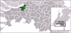
- Drimmelen
-
Drimmelen — Municipality — 
Flag
Coat of armsCoordinates: 51°42′N 4°47′E / 51.7°N 4.783°E Country Netherlands Province North Brabant Area(2006) - Total 119.20 km2 (46 sq mi) - Land 96.24 km2 (37.2 sq mi) - Water 22.96 km2 (8.9 sq mi) Population (1 January, 2007) - Total 26,558 - Density 276/km2 (714.8/sq mi) Source: CBS, Statline. Time zone CET (UTC+1) - Summer (DST) CEST (UTC+2) Drimmelen (
 pronunciation (help·info)) is a municipality and a town in the southern Netherlands.
Population centres
Towns:
- Made (population: 11,710)
- Terheijden (6,410)
- Lage Zwaluwe (4,060)
- Wagenberg (2,250)
- Hooge Zwaluwe (1,670)
- Drimmelen (570)
Hamlets (population data concerning these hamlets are included in the population data of the towns near which they are located):
- Blauwe Sluis
- Oud-Drimmelen
- Helkant
Transportation
The Lage Zwaluwe railway station is situated on the Breda–Rotterdam railway and the railway to Roosendaal.
External links
Aalburg · Alphen-Chaam · Asten · Baarle-Nassau · Bergeijk · Bergen op Zoom · Bernheze · Best · Bladel · Boekel · Boxmeer · Boxtel · Breda · Cranendonck · Cuijk · Deurne · Dongen · Drimmelen · Eersel · Eindhoven · Etten-Leur · Geertruidenberg · Geldrop-Mierlo · Gemert-Bakel · Gilze en Rijen · Goirle · Grave · Haaren · Halderberge · Heeze-Leende · Helmond · 's-Hertogenbosch · Heusden · Hilvarenbeek · Laarbeek · Landerd · Loon op Zand · Maasdonk · Mill en Sint Hubert · Moerdijk · Nuenen, Gerwen en Nederwetten · Oirschot · Oisterwijk · Oosterhout · Oss · Reusel-De Mierden · Roosendaal · Rucphen · Schijndel · Sint Anthonis · Sint-Michielsgestel · Sint-Oedenrode · Someren · Son en Breugel · Steenbergen · Tilburg · Uden · Valkenswaard · Veghel · Veldhoven · Vught · Waalre · Waalwijk · Werkendam · Woensdrecht · Woudrichem · Zundert

See also: Netherlands · Provinces · Municipalities Coordinates: 51°42′N 4°47′E / 51.7°N 4.783°E
Categories:- Municipalities of North Brabant
- Populated places in North Brabant
- North Brabant geography stubs
Wikimedia Foundation. 2010.

