Halderberge

Halderberge

Infobox Settlement
official_name = Halderberge
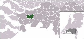

mapsize = 280px
subdivision_type = Country
subdivision_name = Netherlands
subdivision_type1 = Province
subdivision_name1 = North Brabant
area_footnotes = (2006)
area_total_km2 = 75.24
area_land_km2 = 74.64
area_water_km2 = 0.60
population_as_of = 1 January, 2007
population_note = Source: CBS, [http://statline.cbs.nl/ Statline] .
settlement_type = Municipality
population_total = 29349
population_density_km2 = 393
timezone = CET
utc_offset = +1
timezone_DST = CEST
utc_offset_DST = +2

Halderberge (pronunciation|198 Halderberge.ogg) is a municipality in the southern Netherlands.

Population centres

*Oudenbosch (population: 13,110)
*Hoeven (6,560)
*Oud Gastel (6,360)
*Bosschenhoofd (2,180)
*Stampersgat (1,330)

Transportation

External links

* [http://www.halderberge.nl Official Website]


Wikimedia Foundation. 2010.

Игры ⚽ Поможем решить контрольную работу

Look at other dictionaries:

  • Halderberge — Héraldique …   Wikipédia en Français

  • Halderberge — Gemeinde Halderberge Flagge Wappen Provinz Nordbrabant Bürgermeister …   Deutsch Wikipedia

  • Kruisstraat (Halderberge) — Kruisstraat is a hamlet in the Dutch province of North Brabant. It is located in the municipality of Halderberge, between the towns of Oudenbosch and Hoeven. ANWB Topografische Atlas Nederland , Topografische Dienst and ANWB, 2005.] References …   Wikipedia

  • Gemeente Halderberge — Admin ASC 2 Code Orig. name Gemeente Halderberge Country and Admin Code NL.06.1655 NL …   World countries Adminstrative division ASC I-II

  • Oudenbosch — Gemeinde Halderberge Flagge Wappen Provinz …   Deutsch Wikipedia

  • Christianen — Arjan Christianen Spielerinformationen Geburtstag 19. Dezember 1982 Geburtsort Halderberge, Niederlande Größe 188 cm Position Torwart Vereine in der Jugend …   Deutsch Wikipedia

  • Liste der ehemaligen Gemeinden in Nordbrabant — Hierunter folgt eine Liste der ehemaligen nordbrabantischen Gemeinden. Wenn das Gebiet einer aufgehobenen Gemeinde über mehrere Gemeinden verteilt worden ist, ist das Großteil der erstgenannten Gemeinde hinzugefügt. Grenzkorrekturen zwischen… …   Deutsch Wikipedia

  • Hoeven — 51°34′39″N 4°34′51″E / 51.5775, 4.58083 …   Wikipédia en Français

  • Oudenbosch — 51°35′21″N 4°31′26″E / 51.58917, 4.52389 …   Wikipédia en Français

  • Bosschenhoofd — 51°33′38″N 4°32′29″E / 51.56056, 4.54139 …   Wikipédia en Français

Share the article and excerpts

Direct link
Do a right-click on the link above
and select “Copy Link”