- De Ronde Venen
-
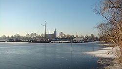
De Ronde Venen — Municipality — Vinkeveen 
Flag
Coat of armsCoordinates: 52°12′N 4°52′E / 52.20°N 4.87°ECoordinates: 52°12′N 4°52′E / 52.20°N 4.87°E Country Netherlands Province Utrecht Area(2006) - Total 84.80 km2 (32.7 sq mi) - Land 70.65 km2 (27.3 sq mi) - Water 14.14 km2 (5.5 sq mi) Population (1 January, 2007) - Total 34,589 - Density 490/km2 (1,269.1/sq mi) Source: CBS, Statline. Time zone CET (UTC+1) - Summer (DST) CEST (UTC+2) Website www.derondevenen.nl De Ronde Venen (
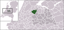
 pronunciation (help·info)) is a municipality in the Netherlands, in the province of Utrecht.
Population centres
The municipality of De Ronde Venen consists of the villages Amstelhoek, De Hoef, Mijdrecht, Vinkeveen, Waverveen, and Wilnis, and a number of hamlets, such as Aan de Zuwe and Achterbos. As of January 1, 2011 Abcoude, Baambrugge and Stokkelaarsbrug also belong to De Ronde Venen.
References
- Statistics are taken from the SDU Staatscourant
External links
- (Dutch) Official website
- (Dutch) A map of the municipality
Villages Hamlets Aan de Zuwe | Achterbos | Baambrugse Zuwe | Demmerik | Donkereind | Geer | Gemaal | Groenlandsekade | Kromme Mijdrecht | Nessersluis | Stokkelaarsbrug | VinkekadeList of cities, towns and villages in Utrecht Amersfoort · Baarn · Bunnik · Bunschoten · De Bilt · De Ronde Venen · Eemnes · Houten · IJsselstein · Leusden · Lopik · Montfoort · Nieuwegein · Oudewater · Renswoude · Rhenen · Soest · Stichtse Vecht · Utrecht · Utrechtse Heuvelrug · Veenendaal · Vianen · Wijk bij Duurstede · Woerden · Woudenberg · Zeist

See also: Netherlands · Provinces · Municipalities Categories:- Municipalities of Utrecht (province)
- Utrecht geography stubs
Wikimedia Foundation. 2010.


