- Montfoort
-
Montfoort — Municipality — 
Flag
Coat of armsCoordinates: 52°03′N 4°57′E / 52.05°N 4.95°ECoordinates: 52°03′N 4°57′E / 52.05°N 4.95°E Country Netherlands Province Utrecht Area(2006) - Total 38.22 km2 (14.8 sq mi) - Land 37.75 km2 (14.6 sq mi) - Water 0.47 km2 (0.2 sq mi) Population (1 January, 2007) - Total 13,473 - Density 357/km2 (924.6/sq mi) Source: CBS, Statline. Time zone CET (UTC+1) - Summer (DST) CEST (UTC+2) Website www.montfoort.nl Montfoort (
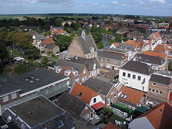
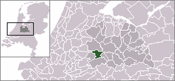
 pronunciation (help·info)) is a municipality and a town in the Netherlands, in the province of Utrecht. Montfoort received city rights in 1329.
Population centres
The municipality of Montfoort consists of the following cities, towns, villages and/or districts: Linschoten, Willeskop.
References
- Statistics are taken from the SDU Staatscourant
External links
Amersfoort · Baarn · Bunnik · Bunschoten · De Bilt · De Ronde Venen · Eemnes · Houten · IJsselstein · Leusden · Lopik · Montfoort · Nieuwegein · Oudewater · Renswoude · Rhenen · Soest · Stichtse Vecht · Utrecht · Utrechtse Heuvelrug · Veenendaal · Vianen · Wijk bij Duurstede · Woerden · Woudenberg · Zeist

See also: Netherlands · Provinces · Municipalities Categories:- Municipalities of Utrecht (province)
- Populated places in Utrecht (province)
- Utrecht geography stubs
Wikimedia Foundation. 2010.


