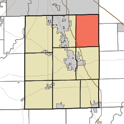
- Clark Township, Johnson County, Indiana
-
Clark Township — Township — Coordinates: 39°35′05″N 85°59′45″W / 39.58472°N 85.99583°WCoordinates: 39°35′05″N 85°59′45″W / 39.58472°N 85.99583°W Country United States State Indiana County Johnson Government - Type Indiana township Area - Total 34.44 sq mi (89.2 km2) - Land 34.42 sq mi (89.14 km2) - Water 0.02 sq mi (0.06 km2) Elevation[1] 774 ft (236 m) Population (2000) - Total 1,900 - Density 55.2/sq mi (21.31/km2) FIPS code 18-12781[2] GNIS feature ID 453201 Clark Township is one of nine townships in Johnson County, Indiana. As of the 2000 census, its population was 1,900.
References
- ^ "US Board on Geographic Names". United States Geological Survey. 2007-10-25. http://geonames.usgs.gov. Retrieved 2008-01-31.
- ^ "American FactFinder". United States Census Bureau. http://factfinder.census.gov. Retrieved 2008-01-31.
External links
Municipalities and communities of Johnson County, Indiana County seat: Franklin Cities Towns Townships Blue River | Clark | Franklin | Hensley | Needham | Nineveh | Pleasant | Union | White River
Unincorporated
communitiesAmity | Anita | Banta | Bluff Creek | Bud | Critchfield | El Dorado | Frances | Green Valley | Hendricks | Hopewell | Kinder | McCarty | Mount Pleasant | Needham | Nineveh | Old Bargersville | Peoga | Providence | Reds Corner | Rocklane | Samaria | Smith Valley | Spring Hill | Stones Crossing | Urmeyville | Waterloo
Footnotes ‡This populated place also has portions in an adjacent county or counties
Categories:- Townships in Johnson County, Indiana
- Indianapolis-Anderson-Columbus geography stubs
Wikimedia Foundation. 2010.

