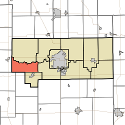
- Monroe Township, Howard County, Indiana
-
Monroe Township — Township — Location in Howard County Coordinates: 40°27′06″N 86°18′59″W / 40.45167°N 86.31639°WCoordinates: 40°27′06″N 86°18′59″W / 40.45167°N 86.31639°W Country United States State Indiana County Howard Government – Type Indiana township Area – Total 19.19 sq mi (49.69 km2) – Land 19.19 sq mi (49.69 km2) – Water 0 sq mi (0 km2) 0% Elevation 810 ft (247 m) Population (2010) – Total 1,407 – Density 72.3/sq mi (27.9/km2) GNIS feature ID 0453639 Monroe Township is one of eleven townships in Howard County, Indiana, USA. As of the 2010 census, its population was 1,407.
Contents
Geography
Monroe Township covers an area of 19.19 square miles (49.7 km2). The streams of Little Wildcat Creek, Walnut Fork and West Honey Creek run through this township.
Unincorporated towns
- New London
- Shanghai
(This list is based on USGS data and may include former settlements.)
Adjacent townships
- Ervin Township (north)
- Clay Township (northeast)
- Harrison Township (east)
- Honey Creek Township (southeast)
- Forest Township, Clinton County (south)
- Warren Township, Clinton County (southwest)
- Burlington Township, Carroll County (west)
Major highways
References
External links
Municipalities and communities of Howard County, Indiana City Towns Townships Unincorporated
communitiesAlto | Cassville | Center | Darrough Chapel | Guy | Hemlock | Indian Heights | Jerome | Judson | Kappa Corner | New London | Oakford | Phlox | Plevna | Ridgeway | Shanghai | Sycamore | Vermont | West Liberty | West Middleton
Categories:- Townships in Howard County, Indiana
- Kokomo metropolitan area
Wikimedia Foundation. 2010.

