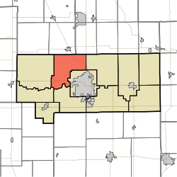
- Clay Township, Howard County, Indiana
-
Clay Township — Township — Location in Howard County Coordinates: 40°31′22″N 86°11′37″W / 40.52278°N 86.19361°WCoordinates: 40°31′22″N 86°11′37″W / 40.52278°N 86.19361°W Country United States State Indiana County Howard Government - Type Indiana township Area - Total 28.75 sq mi (74.45 km2) - Land 28.71 sq mi (74.35 km2) - Water 0.04 sq mi (0.1 km2) 0.13% Elevation 820 ft (250 m) Population (2010) - Total 3,885 - Density 140.8/sq mi (54.4/km2) GNIS feature ID 0453211 Clay Township is one of eleven townships in Howard County, Indiana, USA. As of the 2010 census, its population was 3,885.
Contents
Geography
Clay Township covers an area of 28.75 square miles (74.5 km2); of this, 0.04 square miles (0.10 km2) or 0.13 percent is water. The stream of Villa Run runs through this township.
Adjacent townships
- Jackson Township, Cass County (north)
- Deer Creek Township, Miami County (northeast)
- Howard Township (east)
- Center Township (southeast)
- Harrison Township (south)
- Monroe Township (southwest)
- Ervin Township (west)
Major highways
 US 31
US 31 US 35
US 35 SR 22
SR 22
Airports and landing strips
- Hartman Farms Field
References
- "Clay Township, Howard County, Indiana". Geographic Names Information System, U.S. Geological Survey. http://geonames.usgs.gov/pls/gnispublic/f?p=gnispq:3:::NO::P3_FID:0453211. Retrieved 2009-09-24.
- United States Census Bureau cartographic boundary files
External links
Municipalities and communities of Howard County, Indiana County seat: Kokomo City Towns Townships Unincorporated
communitiesAlto | Cassville | Center | Darrough Chapel | Guy | Hemlock | Indian Heights | Jerome | Judson | Kappa Corner | New London | Oakford | Phlox | Plevna | Ridgeway | Shanghai | Sycamore | Vermont | West Liberty | West Middleton
Categories:- Townships in Howard County, Indiana
- Kokomo metropolitan area
Wikimedia Foundation. 2010.

