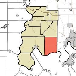
- Marrs Township, Posey County, Indiana
-
Marrs Township
Posey County— Township — Coordinates: 37°56′47″N 87°45′21″W / 37.94639°N 87.75583°WCoordinates: 37°56′47″N 87°45′21″W / 37.94639°N 87.75583°W Country United States State Indiana County Posey Government - Type Indiana township Area - Total 52.12 sq mi (134.98 km2) - Land 51.54 sq mi (133.5 km2) - Water 0.57 sq mi (1.48 km2) Elevation[1] 436 ft (133 m) Population (2000) - Total 4,868 - Density 94.44/sq mi (36.47/km2) FIPS code 18-47250[2] GNIS feature ID 453614 Marrs Township is one of ten townships in Posey County, Indiana. As of the 2000 census, its population was 4,868.
Contents
Adjacent Townships
- Indiana
- Posey County
- Black Township (West)
- Lynn Township (Single Point - Northwest)
- Robinson Township (North)
- Vanderburgh County
- German Township (Single Point - Northeast)
- Perry Township (East)
- Posey County
- Kentucky
- Henderson County
- Corydon District (South)
- Henderson County
Unincorporated Places
- Caborn
- Heusler
- Lippe
- Marrs Center
- Philip Station
- St. Philip
- West Franklin
References
- ^ "US Board on Geographic Names". United States Geological Survey. 2007-10-25. http://geonames.usgs.gov. Retrieved 2008-01-31.
- ^ "American FactFinder". United States Census Bureau. http://factfinder.census.gov. Retrieved 2008-01-31.
External links
Municipalities and communities of Posey County, Indiana County seat: Mount Vernon City Towns Townships Unincorporated
communitiesBlairsville | Caborn | Farmersville | Hovey | Savah | St Phillip | St Wendel | Stewartsville | Solitude | Upton | Wadesville | West Franklin
Categories:- Townships in Posey County, Indiana
- Southern Indiana geography stubs
- Indiana
Wikimedia Foundation. 2010.

