- Ahmeek, Michigan
Infobox Settlement
official_name = Ahmeek, Michigan
settlement_type = Village
nickname =
motto =
imagesize =
image_caption =
image_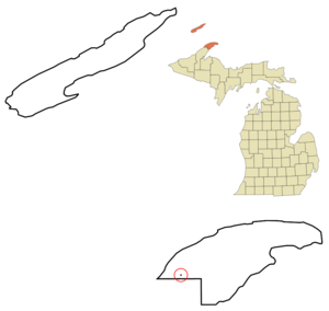
mapsize = 250px
map_caption = Location of Ahmeek in Keweenaw County, Michigan
mapsize1 =
map_caption1 =subdivision_type = Country
subdivision_name =United States
subdivision_type1 = State
subdivision_name1 =Michigan
subdivision_type2 = County
subdivision_name2 = Keweenawgovernment_footnotes =
government_type =
leader_title =
leader_name =
leader_title1 =
leader_name1 =
established_title =
established_date =area_footnotes =
area_magnitude =
area_total_km2 = 0.2
area_land_km2 = 0.2
area_water_km2 = 0.0
area_total_sq_mi = 0.1
area_land_sq_mi = 0.1
area_water_sq_mi = 0.0population_as_of = 2000
population_footnotes =
population_total = 157
population_density_km2 = 864.1
population_density_sq_mi = 2237.9timezone = Eastern (EST)
utc_offset = -5
timezone_DST = EDT
utc_offset_DST = -4
elevation_footnotes =
elevation_m = 265
elevation_ft = 869
latd = 47 |latm = 17 |lats = 52 |latNS = N
longd = 88 |longm = 23 |longs = 50 |longEW = Wpostal_code_type =
ZIP code
postal_code = 49901
area_code = 906
blank_name = FIPS code
blank_info = 26-00620GR|2
blank1_name = GNIS feature ID
blank1_info = 0619873 [gnis|0619873]
website =
footnotes =Ahmeek is a village in Keweenaw County in the
U.S. state ofMichigan . As of the 2000 census, the village population was 157. The village is in Allouez Township.Geography
According to the
United States Census Bureau , the village has a total area of 0.1square mile s (0.2km² ), all land.Based on total area, Ahmeek holds the distinction of being the largest incorporated community, in the largest county (Keweenaw County, 5,965.96 square miles), in the largest state (Michigan, 96,716.11 square miles), east of the
Mississippi River , located within theUnited States .Demographics
As of the
census GR|2 of 2000, there were 157 people, 82 households, and 36 families residing in the village. Thepopulation density was 2,237.9 per square mile (866.0/km²). There were 120 housing units at an average density of 1,710.5/sq mi (661.9/km²). The racial makeup of the village was 96.82% White, 0.64% Asian, and 2.55% from two or more races. 29.1% were of Finnish, 19.6% Italian, 12.2% German, 12.2% English and 7.4% French ancestry.There were 82 households out of which 18.3% had children under the age of 18 living with them, 34.1% were married couples living together, 3.7% had a female householder with no husband present, and 54.9% were non-families. 48.8% of all households were made up of individuals and 23.2% had someone living alone who was 65 years of age or older. The average household size was 1.91 and the average family size was 2.84.
In the village the population was spread out with 19.1% under the age of 18, 3.2% from 18 to 24, 31.2% from 25 to 44, 24.2% from 45 to 64, and 22.3% who were 65 years of age or older. The median age was 43 years. For every 100 females there were 137.9 males. For every 100 females age 18 and over, there were 139.6 males.
The median income for a household in the village was $24,231, and the median income for a family was $33,750. Males had a median income of $21,563 versus $21,250 for females. The
per capita income for the village was $16,188. About 8.3% of families and 11.5% of the population were below thepoverty line , including none of those under the age of eighteen and 5.9% of those sixty five or over.References

Wikimedia Foundation. 2010.