- Cowbit
-
Coordinates: 52°44′38″N 0°08′03″W / 52.743769°N 0.13405882°W
Cowbit 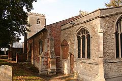
St Mary's church, Cowbit
 Cowbit
Cowbit shown within LincolnshireOS grid reference TF 26059 17871 District South Holland Shire county Lincolnshire Region East Midlands Country England Sovereign state United Kingdom Post town Spalding Postcode district PE12 Police Lincolnshire Fire Lincolnshire Ambulance East Midlands EU Parliament East Midlands UK Parliament South Holland and The Deepings List of places: UK • England • Lincolnshire Cowbit (locally pronounced Cubbit) is a village and civil parish in the South Holland district of Lincolnshire,[1] England. It lies 3 miles (4.8 km) South of Spalding and 5 miles (8 km) North of Crowland.
Cowbit falls within the drainage area of the Welland and Deepings Internal Drainage Board.
Cowbit Grade I listed Anglican parish church is dedicated to St Mary.[2] The church was built on a small scale in the 14th century by Prior de Moulton of Spalding. A chancel and Perpendicular tower were added by Bishop Russell of Lincoln in 1487. Restoration was carried out in 1882.[3] A Wesleyan chapel was built in 1842, and rebuilt in 1861.[4] To the south, on the road to the hamlet of Peak Hill, is a stone named after St Guthlac, being a boundary marker for the earlier lands of Crowland Abbey.[4]
The village has a Grade II listed early 19th century Mill,[5] a Church of England primary school, a public house, public play area, village hall, and a garage with shop.
On 16 October 2011, work was completed on a new bypass for the A1073,[6] which previously ran through the village. This new route has been re-designated to form part of the A16.
Cowbit previously had a railway station on Spalding to March line; the line is no longer in use.
Cowbit Wash
Cowbit Wash lies to the east of the village, extends 20 miles (32 km) from north to south, and is nearly a mile broad.[4] Mainly arable land, it is a flood plain for the navigable River Welland, separated from Cowbit by an earth bank that carries an unclassified road.[7] Previously Welland overflow regularly flooded the Wash, the water freezing-over during winter allowing for ice skating and skating championships. A relief channel (Coronation Channel) for the Welland at Spalding has made Cowbit Wash obsolete as a flood plain.
References
- ^ OSGB (03/04/2006). 235 Wisbech & Peterborough North:Market Deeping & Crowland (Map). 1:25 000, OS Explorer (A1 ed.). ISBN 9780319238073.TF265180
- ^ "Church of St Mary", National Heritage List for England, English Heritage. Retrieved 19 July 2011
- ^ Cox, J. Charles (1916) Lincolnshire p. 107; Methuen & Co. Ltd
- ^ a b c Kelly's Directory of Lincolnshire with the port of Hull 1885, p. 369
- ^ "Mill", National Heritage List for England, English Heritage. Retrieved 19 July 2011
- ^ "A1073 - Spalding to Eye Improvement", Lincolnshire County Council. Retrieved 19 July 2011
- ^ "Pumping Station, Cowbit Wash, Lincs", geograph.org.uk. Retrieved 19 July 2011
External links
- "Cowbit", genuki.org.uk. Retrieved 19 July 2011
Categories:- Villages in Lincolnshire
- Civil parishes in Lincolnshire


Wikimedia Foundation. 2010.