- Monson, Maine
-
Monson, Maine — Town — Monson Village, about 1905

SealMotto: By the Shores of Lake Hebron Coordinates: 45°17′11″N 69°30′21″W / 45.28639°N 69.50583°W Country United States State Maine County Piscataquis Area – Total 49.2 sq mi (127.5 km2) – Land 47.1 sq mi (121.9 km2) – Water 2.2 sq mi (5.6 km2) Elevation 896 ft (273 m) Population (2000) – Total 666 – Density 14.1/sq mi (5.5/km2) Time zone Eastern (EST) (UTC-5) – Summer (DST) EDT (UTC-4) ZIP code 04464 Area code(s) 207 FIPS code 23-46580 GNIS feature ID 0582603 Monson is a town in Piscataquis County, Maine, United States. As of the 2000 census, the town had a population of 666. The town is located on Route 15 which is a somewhat major route north to the well known Moosehead Lake Region, to which Monson is sometimes considered a gateway. This route ultimately leads to the Canadian Province of Quebec.
The town is well known in local and state history, but is minimally known elsewhere, although contributions by the town, and its location are notable. It is the last town located on the Appalachian Trail at the beginning (or end) of the 100-Mile Wilderness. It is not uncommon to see many hikers in town resting before (or after) their trip into the Wilderness, and several lodging places in town cater directly to these hikers.
Contents
History
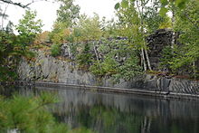 Flooded slate quarry at Monson
Monson was founded on February 8, 1822 by an act of the state legislature. It was named after Monson, Massachusetts.[1] Previously the town was part of a piece of land granted to both Hebron Academy and Monson Academy by the state of Massachusetts in 1811. On April 22, 1822, the town had its first town meeting to form a government. However the first resident first came here in 1816 after being here the previous fall to clear trees out for a settlement. Monson is also referenced in the book The Maine Woods by Henry David Thoreau wherein a drawing of moose antlers depicting the direction and names of both Blanchard and Monson, and the town is mentioned in other sections of the book. The antlers have been stolen and replaced several times, but currently they exist in the approximate location on a pole after leaving the town of Abbot.
In 1870, slate was discovered by a resident who had immigrated from Wales, while driving his horse in the countryside of the town. Over the next few decades many slate quarries were created increasing the population of the town, as well as generating a source of income for residents. Large-scale slate operations required construction of the Monson Railroad in 1883; and two foot gauge locomotives transported slate and passengers to the larger Bangor and Aroostook Railroad in Abbot until 1943.[2] The slating industry began to decline after World War I and most of the operations effectively ended. Currently, Sheldon Slate Company is the only operation that exists in the town, although there is a smaller operation selling typically roofing and landscaping slate. The slate from Monson makes up the Kennedy headstones in Washington D.C.
In 1945, after a fire at Greenville's Moosehead Woodcrafters resulted in the company buying a former slate company's buildings that created a Moosehead Manufacturing, which produced furniture products for over 60 years until its recent closure in 2007. The company had a sister plant located in Dover-Foxcroft, and a store in North Carolina, and shipped its products all over the state, country, and even as far away as Japan and other countries. The operation created many jobs for several generations, and it was not uncommon that fathers and sons, as well as mothers and daughters would work together. The town was greatly impacted by the revenue and income generated by the company, and had as many as 250 workers who lived either in town or in several communities around the town.
Throughout its history, Monson has been greatly surpassed by its neighbors to the north by means of tourism. The town had a hotel, and even a steamboat that took people on trips on Lake Hebron in the late 19th century and early 20th century, but due to several causes, the hotel and many of the local businesses dealing with tourism in the early 20th century were diminished. Since the 1990s, Monson has increased again in tourism and, with the closure of Moosehead Manufacturing, many consider Monson (as well as much of Piscataquis County), to cater towards tourism. This is evidenced in the rise of antique shops, a new pub and lodging, and several similar businesses increasing on Main Street.
Schools
Monson had a primary and secondary school known as Monson Academy. Although the school had begun classes in 1847, a longer lasting building did not succeed (due to fires) until 1861. The school remained in session till 1968 when the buildings were remodeled and 7th through 12th grades began to be bussed to Dover-Foxcroft. Graduates from Foxcroft Academy are essentially graduates from Monson Academy, however no degree or ceremony is given for these graduates. There is also a small but remaining Monson Academy Alumni, that consists of mostly people born between 1920 and 1950. The Academy also had won state basketball tournaments in the 1950s and 1960s and many of the trophies, and other memorabilia from the school are held within the Monson Museum, and can be viewed. The school team was known as the Slaters and their colors were orange and black.
Currently, Monson Elementary and the gymnasium which is used for local and private events are still located on the site of the original school buildings as well as a recently restored band stand. Monson Elementary began operations in the 1980s and extension was created in the 1990s that created room for a new library and school rooms. The school only enrolls about 40 pupils, and only holds grades K through 4 as well as a pre-school. The elementary school is currently part of MSAD 68. Residents of the town due to a ruling by the MSAD 68 Board of Directors decided to close Monson Elementary after the 2008-2009 school year. An effort however has begun to reorganize the school's partnerships with either Union 60 in Greenville or MSAD 4 in Guilford.
Geography
According to the United States Census Bureau, the town has a total area of 49.2 square miles (127 km2), of which, 47.1 square miles (122 km2) of it is land and 2.2 square miles (5.7 km2) of it (4.41%) is water.
Demographics
As of the census[3] of 2000, there were 666 people, 295 households, and 179 families residing in the town. The population density was 14.1 people per square mile (5.5/km²). There were 564 housing units at an average density of 12.0 per square mile (4.6/km²). The racial makeup of the town was 98.20% White, 0.30% Native American, 0.30% from other races, and 1.20% from two or more races. Hispanic or Latino of any race were 0.45% of the population.
There were 293 households out of which 26.4% had children under the age of 18 living with them, 49.5% were married couples living together, 7.5% had a female householder with no husband present, and 39.3% were non-families. 34.6% of all households were made up of individuals and 13.9% had someone living alone who was 65 years of age or older. The average household size was 2.25 and the average family size was 2.91.
In the town the population was spread out with 23.4% under the age of 18, 4.4% from 18 to 24, 26.4% from 25 to 44, 28.2% from 45 to 64, and 17.6% who were 65 years of age or older. The median age was 42 years. For every 100 females there were 103.0 males. For every 100 females age 18 and over, there were 102.4 males.
The median income for a household in the town was $26,964, and the median income for a family was $34,271. Males had a median income of $26,667 versus $20,962 for females. The per capita income for the town was $14,044. About 9.8% of families and 15.7% of the population were below the poverty line, including 12.4% of those under age 18 and 50.8% of those age 65 or over.
References
- ^ "Profile for Monson, Maine". ePodunk. http://www.epodunk.com/cgi-bin/genInfo.php?locIndex=2239. Retrieved 2010-05-07.
- ^ Jones, Robert C. (1998). Two Feet to the Quarries: The Monson Railroad. Evergreen Press. ISBN 0-9667264-0-5.
- ^ "American FactFinder". United States Census Bureau. http://factfinder.census.gov. Retrieved 2008-01-31.
External links
Municipalities and communities of Piscataquis County, Maine Towns Abbot | Atkinson | Beaver Cove | Bowerbank | Brownville | Dover-Foxcroft | Greenville | Guilford | Medford | Milo | Monson | Parkman | Sangerville | Sebec | Shirley | Wellington | Willimantic
Plantations Unorganized
territoriesCDPs Dover-Foxcroft | Greenville | Guilford | Milo
Coordinates: 45°17′13″N 69°30′04″W / 45.28694°N 69.50111°W
Categories:- Towns in Piscataquis County, Maine


Wikimedia Foundation. 2010.