- Cushing, Maine
-
Cushing, Maine — Town — Olson House Location within the state of Maine
 Cushing, Maine
Coordinates: 43°59′36″N 69°16′5″W / 43.99333°N 69.26806°W Country United States State Maine County Knox Incorporated 1789 Area – Total 26.1 sq mi (67.6 km2) – Land 19.4 sq mi (50.2 km2) – Water 6.7 sq mi (17.4 km2) Elevation 85 ft (26 m) Population (2000) – Total 1,322 – Density 68.1/sq mi (26.3/km2) Time zone Eastern (EST) (UTC-5) – Summer (DST) EDT (UTC-4) ZIP code 04563 Area code(s) 207 FIPS code 23-15780 GNIS feature ID 0582428 Cushing is a town in Knox County, Maine, United States. As of the 2000 census, the town had a total population of 1,322. A favorite of artists for its unspoiled natural setting, Cushing includes the villages of North Cushing, Cushing, South Cushing, and Pleasant Point.
Contents
History
Part of the Waldo Patent, it was called the Lower Plantation of St. Georges, once extending across both sides of the St. George River. It was first permanently settled in 1733 with Scots and Irish immigrants recruited from Ireland by Brigadier-General Samuel Waldo, who offered 100 acres (0.40 km2) for each household. Attacks during the French and Indian Wars, however, deterred habitation. A stone blockhouse known as Burton's Fort was built in 1753 by its commander, Captain Benjamin Burton. Hostilities finally ceased in 1759 with the Fall of Quebec.[1] On January 28, 1789, the town was incorporated and named for Thomas Cushing, statesman and lieutenant governor of Massachusetts. On February 7, 1803, the town of St. George was set off and incorporated.[2]
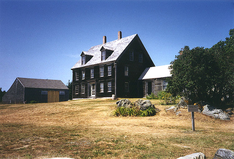
The Olson House was depicted in Andrew Wyeth's 1948 painting, Christina's World, which in turn was used as Dahlia Gillespie's house in the 2006 horror film Silent Hill, and inspired the farmer's house in the 1978 film Days of Heaven. The building is now operated by the Farnsworth Art Museum of Rockland.[3]
Geography
According to the United States Census Bureau, the town has a total area of 26.1 square miles (68 km2), of which, 19.4 square miles (50 km2) of it is land and 6.7 square miles (17 km2) of it (25.74%) is water. Cushing, which includes Gay Island, is situated on Muscongus Bay between the Meduncook River to the west and St. George River to the east.
The town is served by Maine State Route 97. It borders Friendship to the west, Warren and Thomaston, Maine to the north, and separated by the St. George River, South Thomaston and St. George to the east.
Demographics
As of the census[4] of 2000, there were 1,322 people, 541 households, and 383 families residing in the town. The population density was 68.1 people per square mile (26.3/km²). There were 778 housing units at an average density of 40.1 per square mile (15.5/km²). The racial makeup of the town was 99.47% White, 0.08% Asian, 0.08% from other races, and 0.38% from two or more races. Hispanic or Latino of any race were 0.45% of the population. 28.3% were of English, 13.5% American, 9.1% Irish, 7.9% German, 5.9% Finnish, 5.2% French and 5.1% Scottish ancestry according to Census 2000.
There were 541 households out of which 28.3% had children under the age of 18 living with them, 59.5% were married couples living together, 6.7% had a female householder with no husband present, and 29.2% were non-families. 23.7% of all households were made up of individuals and 10.2% had someone living alone who was 65 years of age or older. The average household size was 2.42 and the average family size was 2.82.
In the town the population was spread out with 22.5% under the age of 18, 7.6% from 18 to 24, 27.2% from 25 to 44, 26.2% from 45 to 64, and 16.6% who were 65 years of age or older. The median age was 41 years. For every 100 females there were 100.6 males. For every 100 females age 18 and over, there were 103.0 males.
The median income for a household in the town was $40,598, and the median income for a family was $43,929. Males had a median income of $28,553 versus $22,455 for females. The per capita income for the town was $20,264. About 7.6% of families and 12.8% of the population were below the poverty line, including 20.6% of those under age 18 and 5.9% of those age 65 or over.
Notable people
- Elisabeth Ogilvie, writer
- Edward Robinson, congressman
- Dudley Willis Rockwell, metallurgist
- Andrew Wyeth, artist
References
- ^ Coolidge, Austin J.; John B. Mansfield (1859). A History and Description of New England. Boston, Massachusetts. p. 99. http://books.google.com/books?id=OcoMAAAAYAAJ&lpg=PA9&dq=coolidge%20mansfield%20history%20description%20new%20england%201859&pg=PA99#v=onepage&q&f=false.
- ^ Christoph Schmidt, "A Brief History of Cushing, Maine" 1997
- ^ The Olson House -- Farnsworth Art Museum
- ^ "American FactFinder". United States Census Bureau. http://factfinder.census.gov. Retrieved 2008-01-31.
External links
Municipalities and communities of Knox County, Maine City 
Towns Appleton | Camden | Cushing | Friendship | Hope | Isle au Haut | North Haven | Owls Head | Rockport | St. George | South Thomaston | Thomaston | Union | Vinalhaven | Warren | Washington
Plantation Unorganized
territoryCDPs Other
villagesCoordinates: 44°01′09″N 69°14′23″W / 44.01917°N 69.23972°W
Categories:- Towns in Knox County, Maine


Wikimedia Foundation. 2010.