- Coalville, Iowa
-
Coalville, Iowa — CDP — Location of Coalville, Iowa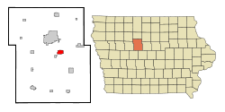
Coordinates: 42°26′37″N 94°7′43″W / 42.44361°N 94.12861°WCoordinates: 42°26′37″N 94°7′43″W / 42.44361°N 94.12861°W Country  United States
State  Iowa
IowaCounty Webster Area – Total 2.2 sq mi (5.6 km2) – Land 2.2 sq mi (5.6 km2) – Water 0.0 sq mi (0.0 km2) Elevation 1,115 ft (340 m) Population (2000) – Total 591 – Density 273.4/sq mi (105.5/km2) Time zone Central (CST) (UTC-6) – Summer (DST) CDT (UTC-5) ZIP code 50501 Area code(s) 515 FIPS code 19-14835 GNIS feature ID 0455503 Coalville is a census-designated place (CDP) in Webster County, Iowa, United States. The population was 591 at the 2000 census. The community is located on U.S. Route 20 near Fort Dodge's large gypsum mines.
Contents
History
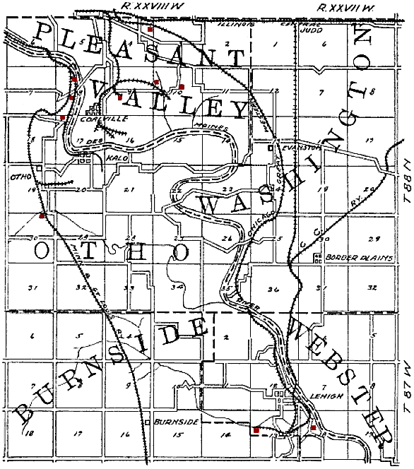
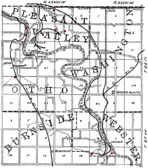 Map of the Coalville area from 1908, showing the railroads and coal mines (shown in red) of the region. Coalville is in the upper left quadrant.
Coalville takes its name from the coal mines of the area. It began as one of the northernmost coal mining towns in Iowa. Early settlers were mining coal from outcrops along the Des Moines River by 1860, and in 1870, a mine was opened on Holiday Creek, about a mile east of Coalville, with a 3-mile tramway to the Dubuque and Sioux City Railroad (later the Illinois Central). Later in 1870, a shaft was sunk at Coalville. The Fort Dodge Coal company took over these mines and opened several more in the Coalville area. By 1880, manual labor was being augmented with machinery in these mines. In 1883, the Fort Dodge Coal company employed 350 miners to produce 30 carloads of coal daily.
The Pleasant Valley Coal Company sank a 105 foot shaft in Coalville in 1895, employing 100 men to mine a 6-foot coal bed. This was mined out in the early 20th century. The Gleason Coal Company sank a shaft in 1899 that operated until 1907, producing 200,000 tons of coal over its lifetime. Gleason sunk a new shaft in 1908.[1]
Geography
Coalville is located at 42°26′37″N 94°07′43″W / 42.443522°N 94.128558°W (42.443522, -94.128558).[2] on the west bank of the Des Moines River.
According to the United States Census Bureau, the CDP has a total area of 2.2 square miles (5.7 km2), all of it land.
Demographics
As of the census[3] of 2000, there were 591 people, 238 households, and 167 families residing in the CDP. The population density was 273.4 people per square mile (105.6/km2). There were 293 housing units at an average density of 135.5 per square mile (52.4/km2). The racial makeup of the CDP was 96.95% White, 1.69% African American, 0.34% Native American, and 1.02% from two or more races. Hispanic or Latino of any race were 0.85% of the population.
There were 238 households out of which 31.5% had children under the age of 18 living with them, 57.6% were married couples living together, 8.4% had a female householder with no husband present, and 29.8% were non-families. 23.5% of all households were made up of individuals and 11.3% had someone living alone who was 65 years of age or older. The average household size was 2.48 and the average family size was 2.96.
In the CDP the population was spread out with 24.9% under the age of 18, 8.3% from 18 to 24, 27.2% from 25 to 44, 25.9% from 45 to 64, and 13.7% who were 65 years of age or older. The median age was 39 years. For every 100 females there were 98.3 males. For every 100 females age 18 and over, there were 97.3 males.
The median income for a household in the CDP was $43,750, and the median income for a family was $45,096. Males had a median income of $33,846 versus $20,855 for females. The per capita income for the CDP was $17,178. None of the families and 2.6% of the population were living below the poverty line, including no under eighteens and 17.8% of those over 64.
See also
Woodman Hollow State Preserve
References
- ^ James H. Lees, History of Coal Mining in Iowa, Chapter III of Annual Report, 1908, Iowa Geological Survey, 1909, pages 581-583.
- ^ "US Gazetteer files: 2010, 2000, and 1990". United States Census Bureau. 2011-02-12. http://www.census.gov/geo/www/gazetteer/gazette.html. Retrieved 2011-04-23.
- ^ "American FactFinder". United States Census Bureau. http://factfinder.census.gov. Retrieved 2008-01-31.
External links
Municipalities and communities of Webster County, Iowa Cities 
Townships Badger | Burnside | Clay | Colfax | Cooper | Dayton | Deer Creek | Douglas | Elkhorn | Fulton | Gowrie | Hardin | Jackson | Johnson | Lost Grove | Newark | Otho | Pleasant Valley | Roland | Sumner | Washington | Webster | Yell
CDP Coalville
Communities Burnside | Lanyon | Lena | Lundgren | Palm Grove | Roelyn | Slifer
Footnotes ‡This populated place also has portions in an adjacent county or counties
Categories:- Census-designated places in Iowa
- Populated places in Webster County, Iowa

Wikimedia Foundation. 2010.