- Bushrod Park, Oakland, California
-
Bushrod Park — Neighborhood of Oakland — Location of Bushrod Park in Oakland
Coordinates: 37°50′45″N 122°15′49″W / 37.84576°N 122.26358°W Country United States State California County Alameda City Oakland The Bushrod Park neighborhood in North Oakland, Oakland, California is an area surrounding its namesake park, and bounded by Martin Luther King, Jr. Way to the west, Claremont Avenue to the east, Highway 24 to the south, and the Berkeley border to the north.[1] It borders the neighborhoods of Sante Fe to the west, Fairview Park to the east, and Temescal and Shafter to the south and southeast, respectively. Notable landmarks include the Bushrod Park ballfields and the former Bushrod Washington Elementary School, which share adjoining land on a large greenbelt and open space in the heart of the neighborhood.
Contents
Parks
Bushrod Park
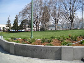 Shattuck Avenue entrance to Bushrod Park
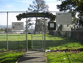 Bushrod Ballfields
At 10.12 acres (41,000 m2),[2] Bushrod is one of the largest parks in the North Oakland section of Oakland, California. It is located between Shattuck Avenue and Racine Street to the east and west, and between 61st Street and 59th Street to the north and south.
The park was established in 1903 through the donation of seven and a half acres of land[3] by Dr. Bushrod Washington James, a resident of Philadelphia, Pennsylvania.[3][4] In the 1910s it was used as a school playground.[3] It has had a long association with local baseball; baseball players Ricky Henderson, Frank Robinson, Billy Martin, and Vada Pinson played at Bushrod in their youth.[5] In 2004 the park was full of drug dealers, and was avoided by many in the area.
In the 1960s, the park was used as a practice field by the Oakland Raiders.[6][7]
On April 8, 2006, a block of ice fell from the sky and landed in the park, leaving a crater that was several feet wide.[8][9]
Neighborhood Demographics
The Bushrod Park neighborhood is 44.7% African-American, 35.3% White, 9.7% Hispanic, and 7.6% Asian [1][2].
Colby Park
 Colby Park as seen from Colby Street
At only 0.35 acres (1,400 m2), Colby Park is one of the smallest parks in North Oakland. It is situated at 61st & Colby Street, and features a sand pit and playground equipment.
Shooting
On February 18, 2005 neighborhood resident Patrick McCullough shot his 15 year old neighbor Melvin McHenry in a confrontation with several youths over McCullough previously reporting suspicious activities to the police. The Oakland District Attorney found that McCullough had acted in self-defense, and no charges were brought against anyone involved in the incident.[10][11]
Schools
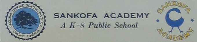
Sankofa Academy
 Sankofa Academy logo
The Sankofa Academy is a public school that occupies the building previously used by the Bushrod Washington Elementary School, adjacent to Bushrod Park at 61st Street and Shattuck Avenue.[12] The school was founded in 2005[13] and is a member of the Oakland Small Schools Foundation.[14]
Peralta Elementary School
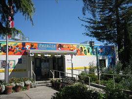 Peralta Elementary School
Peralta Elementary School is a designated arts anchor school in the Oakland Unified School District. It was established in 1880 as a one-room schoolhouse, and today has over 250 students. It is also one of the top ranked Elementary schools in the Oakland and Berkeley neighborhoods.[15]
Coordinates: 37°50′45″N 122°15′49″W / 37.8457599°N 122.2635802°W
References
- ^ "Neighborhood Search Map". Oakland Museum of California. Archived from the original on 2009-04-30. http://web.archive.org/web/20090430211848/http://collections.museumca.org/search_map.jsp. Retrieved 2011-07-29.
- ^ "Parks Listing — City of Oakland Parks and Recreation website". http://www.oaklandnet.com/parks/parks/parkslisting.asp?pgSet=2.
- ^ a b c Joseph Baker. Alameda County History:Past and Present of Alameda County, California. S. J. Clarke Pub. Co., 1914. http://www.calarchives4u.com/history/alameda/1914-ch20b.htm.
- ^ "Bequests by Dr. James". New York Times. January 17, 1903. http://query.nytimes.com/gst/abstract.html?res=9506EEDF1F3DEE32A25754C1A9679C946297D6CF.
- ^ "Baseball's summer classic -- back in the Bay Area". USA Today. 2007-07-10. http://www.mywire.com/pubs/USATODAY/2007/07/10/3944267?extID=10037&oliID=229.
- ^ "A Visit to Bushrod — City of Oakland, Parks and Recreation website". http://www.oaklandnet.com/parks/news/091802i.asp.
- ^ Lee Grosscup (August 1967). "Spying in Pro Football". SPORT. http://www.thesportgallery.com/sport-stories/1967aug-nflspy.html.
- ^ "Huge Block Of Ice Falls From Sky In Oakland". 2006-04-09. http://www.ktvu.com/news/8575846/detail.html.
- ^ Johnson, Jason B. (2006-04-09). "Flying ice chunk leaves hole — and mystery — in park". The San Francisco Chronicle. http://www.sfgate.com/cgi-bin/article.cgi?f=/c/a/2006/04/09/BAG3OI6D091.DTL&feed=rss.bayarea.
- ^ Jim Herron Zamora (2006-02-18). "A Neighborhood Reborn: A year after Patrick McCullough shot teen, Oakland's 59th Street has safer rec center, reduced loitering and fewer drug deals". San Francisco Chronicle. http://www.sfgate.com/cgi-bin/article.cgi?f=/c/a/2006/02/18/MNG0EHB6VK1.DTL&feed=rss.news.
- ^ "McCullough for City Council: Answer to a Frequently Asked Question". http://pat4oakland.com/news/news_categories.php?categoryid=3§ion=ACM&seq=11.
- ^ "OAKLAND: The Birth of a School / At Sankofa Academy, even the principal's new", San Francisco Chronicle, September 25, 2005
- ^ "OAKLAND / Transcending the ABCs / Sankofa Academy encourages students to express opinions", San Francisco Chronicle, April 3, 2006
- ^ "Sankofa Academy : Oakland Small Schools Foundation". http://www.smallschoolsfoundation.org/node/99.
- ^ "Welcome back to Peralta!". http://www.peraltaschool.org/.
Images
 Panoramic view of the neighborhood surrounding Bushrod Park.
Oakland, California neighborhoods Downtown / Lake Merritt East Oakland Dimond District · Eastmont · Elmhurst · Fruitvale · Glenview · Grass Valley · Havenscourt · Laurel · Millsmont · Maxwell Park · Peralta Hacienda · Redwood Heights · Ridgemont · San Antonio · Seminary · Sequoyah Heights · Sobrante Park
North Oakland Bushrod Park · Golden Gate · Koreatown · Longfellow · Piedmont Avenue · Rockridge · Santa Fe · Temescal
West Oakland Oakland Hills Claremont · Montclair · Piedmont Pines · Oakmore · Joaquin Miller Park · Mountain View Cemetery · Sequoyah Heights · Panoramic Hill
Categories:- Neighborhoods in Oakland, California
- High school baseball venues in the United States
- Parks in Oakland, California


Wikimedia Foundation. 2010.