- Orchard, Iowa
-
Orchard, Iowa — City — Orchard, Iowa, 2008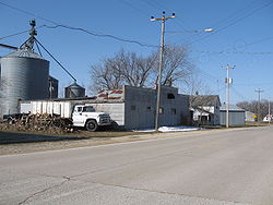 Location of Orchard, Iowa
Coordinates: 43°13′37″N 92°46′28″W / 43.22694°N 92.77444°WCoordinates: 43°13′37″N 92°46′28″W / 43.22694°N 92.77444°W Country United States State Iowa County Mitchell Area – Total 0.1 sq mi (0.2 km2) – Land 0.1 sq mi (0.2 km2) – Water 0.0 sq mi (0.0 km2) Elevation 1,102 ft (336 m) Population (2000) – Total 88 – Density 994.7/sq mi (384.1/km2) Time zone Central (CST) (UTC-6) – Summer (DST) CDT (UTC-5) ZIP code 50460 Area code(s) 641 FIPS code 19-59520 GNIS feature ID 0459886 Orchard is a city in Mitchell County, Iowa, United States. The population was 88 at the 2000 census.
Contents
History
The ghost town of Lithograph City, about 2 miles southwest of Orchard, was founded in the early 1900s adjacent to quarries that produced lithographic limestone. Production in these quarries peaked during World War I when access to German lithographic limestone was cut off. In 1915, Lithograph City had 15 houses, a hotel, a dance hall and a museum. After the war, use of stone blocks in lithography declined, the city was renamed Devonia, and by 1938, no trace of the town remained.[1]
Geography
Orchard is located at 43°13′37″N 92°46′28″W / 43.22694°N 92.77444°W (43.226995, -92.774567)[2].
According to the United States Census Bureau, the city has a total area of 0.1 square miles (0.26 km2), all of it land.
Demographics
As of the census[3] of 2000, there were 88 people, 33 households, and 23 families residing in the city. The population density was 994.7 people per square mile (377.5/km²). There were 35 housing units at an average density of 395.6 per square mile (150.2/km²). The racial makeup of the city was 100.00% White.
There were 33 households out of which 30.3% had children under the age of 18 living with them, 60.6% were married couples living together, 9.1% had a female householder with no husband present, and 27.3% were non-families. 21.2% of all households were made up of individuals and 9.1% had someone living alone who was 65 years of age or older. The average household size was 2.67 and the average family size was 2.92.
In the city the population was spread out with 29.5% under the age of 18, 6.8% from 18 to 24, 28.4% from 25 to 44, 15.9% from 45 to 64, and 19.3% who were 65 years of age or older. The median age was 36 years. For every 100 females there were 100.0 males. For every 100 females age 18 and over, there were 106.7 males.
The median income for a household in the city was $19,583, and the median income for a family was $21,250. Males had a median income of $32,500 versus $22,083 for females. The per capita income for the city was $10,148. There were 22.2% of families and 25.3% of the population living below the poverty line, including 25.0% of under eighteens and 38.1% of those over 64.
References
- ^ Bill J. Bunker, Lithograph City web page of the Iowa Geological Survey.
- ^ "US Gazetteer files: 2010, 2000, and 1990". United States Census Bureau. 2011-02-12. http://www.census.gov/geo/www/gazetteer/gazette.html. Retrieved 2011-04-23.
- ^ "American FactFinder". United States Census Bureau. http://factfinder.census.gov. Retrieved 2008-01-31.
Municipalities and communities of Mitchell County, Iowa Cities Carpenter | McIntire | Mitchell | Orchard | Osage | Riceville‡ | St. Ansgar | Stacyville

Unincorporated
communitiesFootnotes ‡This populated place also has portions in an adjacent county or counties
Categories:- Populated places in Mitchell County, Iowa
- Cities in Iowa

Wikimedia Foundation. 2010.